|
I played hooky from
work on Wednesday and headed North to Lakes of the Clouds on Mt. Washington to
insure getting in at least one dive this season before the water in the lake
begins to cool down. Two years ago, in 2010, I learned a valuable lesson about hypothermia
by diving too late in August. The water temperature on Wednesday was in the mid-50s
and the ambient air temperature was in the low-60s, a much better
combination then 2010. The wind was light and the sun was out on Wednesday, too, which made a huge difference in the chill factor. It was a peach of a day as these photo proclaims.
|
-->
Looking south down the lake with the striking shark's tooth-shaped rock in the foreground.
Looking towards the northeast corner of the lake. Technically we should be calling Lakes of the Clouds a "tarn" a word that means "a small lake formed in a cirque excavated by a glacier" or a steep-banked mountain lake, or pool (wikipedia). It could also mean something much simpler like "small natural lake" according to Google which also points out that the word is from Old Norse and, translated, means "a pond". It's a term that I associate with Scotland. The first definition, water filling in a glacial basin, is accurate for Lakes of the Clouds.
(Photo added 8-15-12.) This photo was taken on 6-11-2010 of the northeast corner of the lake with quite a bit of snow still sitting and melting there. The photo illustrates how the lake is fed with water that wends its way from the surrounding
heights down to, and through the lake to the Ammonoosuc River.

This was taken in the summer of 1970 with some of the Lakes croo in for a swim. The rock in the foreground that Dougy is diving off of is the same one you see in the second photo above but submerged this year under 7 inches of water. There are other notable differences in the two photos dated 42 years apart. By the way, I fashioned those bathing trunks for Dougy Dodd using Photoshop because he forgot his. The blue isn't quite right but close enough.
 |
This is the southwest corner of the lake, a small pocket in the surrounding rock ledges. The highest influx of water entering the lake throughout the year probably comes from the steep slopes above the north and southeast corners. Snow and ice melt plus rain (and the other forms of precipitation) provide water for the lake.
Another view of the southwest corner showing Mt. Monroe in the background. This end of the lake is a great vantage point from which to explore the geologic record of the White Mountains and the unique history of how the lake, Mt. Monroe, etc. were formed and by what forces. Everywhere around the lake there's a vast visual catalog of how actions of both local and continental glaciers, over millions of year, shaped this lovely corner of the world. It makes a great classroom. |

A bird's eye view of the south end of the lake. The rocks visible just below the surface in the center of the photo are 4 inches below the surface. In other years they have been 6 inches above. This photo shows the area that I will be snorkeling extensively today. For description purposes I've divided the area in the photo into the northeast quadrant (the area furthest from the camera) and the southwest quadrant towards the bottom of the photo. The northeast quadrant is where the Quillworts are located. The southwest quadrant has the deepest measurement of the lake where it is 7 feet, 1 1/4 inches deep (Larry measured it metrically as 2.2 meters). That's the deepest spot I've located to date and it has been consistent for 47 years.
Looking north west across the outlet towards Mts. Clay and Jefferson.
I slid into the water with fins (my new Rockets which live up to their name), a mask and snorkel
but without a thermal suit, a so-called "wet suit". The water was chilly, a bit
painful at first, but tolerable if I kept moving. The danger point is
when you start feeling comfortably warm because that may indicate a
deepening state of hypothermia. This photo shows what the lake bottom looks like in the south end in terms of texture and topography. This
is towards the northeast quadrant in one of the deepest areas of the
lake with some depth readings of a little over 6 feet.
This is what the center rocks look like from under the water. They consist of solid ledge rising up from an almost continuous sheet of rock coming down from the steep slope at the south end of the lake.
The extreme north end of the lake, at the outlet, is made up of huge and medium sized boulders like these. The lake is 0-2 feet deep at the north end.
 |
| Large and small rocks near the north end in about 2 feet of water that are dusted with the fine silt that was less prevalent two years ago when I visited this same spot. I'll talk more about the silt below but, from my perspective, it feels as though the finer particles of the silt have been been put in a blender on high speed for a brief period. There's a feeling that a perturbation, most probably Hurricane Irene churned up the silt and redeposited it across the lake bottom. The volume of water dumped by Irene on this ridge was prodigious, maybe as much as 11 inches in a 12 hour period. And speaking a moment ago about Dougy Dodd, he was on the ridge the day after Irene and said "it's hard to imagine the sheer volume of water that was running off this mountain" during the height of the storm. |

A photo also showing the bottom closer to the center of the lake with an assortment of stones and small boulders, often referred to as "cobble", coated with the silt that is ubiquitous across the lake floor.
 |
| This is near the center of the lake showing the layer of silt on the lake bottom. Using my finger I measured the silt to a depth of 3 inches in places, but the depth most likely varies if you go around the lake measuring it. It looks and feels like particulate organic matter (POM) resting on a bed of glacial till. In my explorations of the lake I am extremely careful not to disturb anything, the silt, the rocks and particularly the plants. Initially I was going to use SCUBA but decided not to because introducing all that equipment into the lake increased the possibility of contact with the bottom sediments and the plants. When Larry used his SCUBA he had a simple, light weight rig that was less obtrusive: just a suit, a tank and a weight belt. |

Near the northeast edge of the lake (see map below) there's an oval bed on a north-south axis containing the Lakes of the Clouds quillworts that range in density (population) ranging from high to sparse. This photo shows a high density area of the quillwort community. The density speaks to their reproductive strategy. Quillworts are small plants, with a whorl of spine shaped leaves attached to a thick, "corm" or stem with roots extending downwards from the corm (like a tiny potato. You can actually eat the corm if you're starving). The quillworts are spore-bearing meaning there's a sac attached at the base of the leaves called a sporangium in which the reproductive spores are produced and eventually take root near the parent. An increased thickness in the silt layer is also observable in this photo.

Another photo from the summer of 1970s with several interesting comparisons, or references, in addition to the water level. Extent of vegetation is the most interesting comparison for me.The vegetation in this photo from the past looks stressed and less verdant than vegetation in the photo below.
 |
| Lakes of the Clouds, particularly the larger of the two, is the jewel in the crown of the Presidential Range (I think) being one of the most unique and more beautiful features of the high ridge that makes up the Presidentials. It is an alpine lake, situated at an elevation of 5,000 feet in the Alpine Zone of Mt. Washington, and one of a kind in the eastern half of the United States. The presence of a large community of Quillworts within a sizable area along the bottom of the lake certainly makes this lake, or tarn, of great interest. The quillworts have been known for a while, at least since 1937 when Slim Harris, who is mentioned often in this blog, correctly identified the species as Isoestes echinospora var. Braunii |
 |
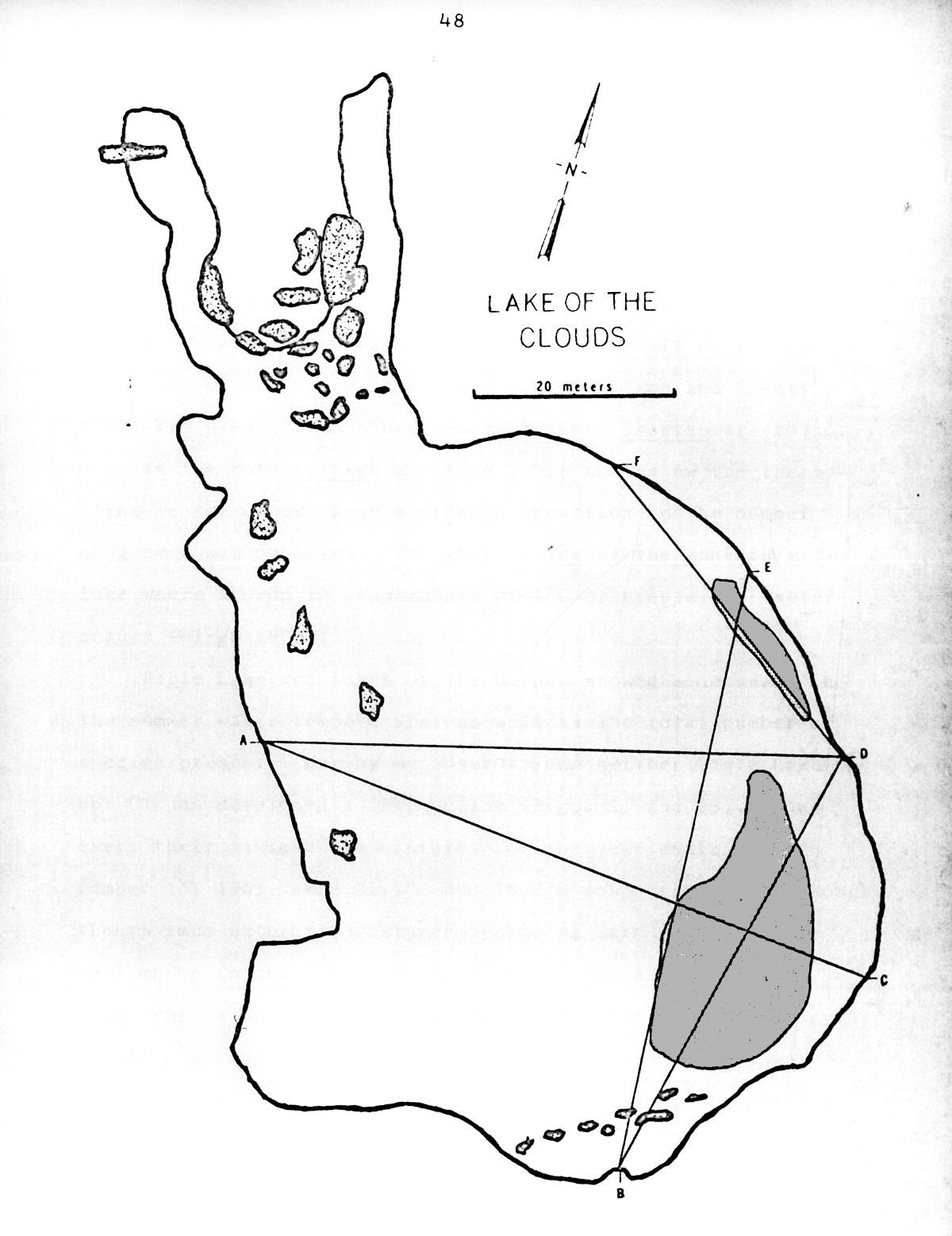
| This is a map of the larger of the two Lakes of the Clouds made by Lawrence Collins in 1965 while researching the aquatic plants, including the quillworts, in two alpine lakes, Lakes of the Clouds, on Mt. Washington, and Eagle Lake, on Mt. Lafayette for his master's thesis. (It looks like a rabbit, doesn't it?) The two darkened oval-shaped areas on the east side of the lake (right side) is where he positioned the quillwort community in 1964-1965. The map is accurate for today, as well. We did the mapping using photographs we took from a small plane flying upside down, Larry at the controls and me snapping pictures with my 35mm Nikon. Unfortunately, the original of this map is on mimeograph paper so it's difficult to get the right contrast. My currrent research is focused on defining the quillwort communtiy today without disturbing it in any way. I plan to use photographs taken underwater for mapping purposes. In my two dives, back in 2010 and the on Wednesday, the quillworts look virtually unchanged with the exception that it appears there's more silt across the lake bottom compared with 2010 that's effecting the quillwort community. |
|
|
 |
| This is Larry's baseline list of aquatic plants that he found stations for in his two "control" lakes he surveyed in 1964-1965: Profile Lake in Franconia Notch, and Partridge Lake in Littleton, NH. He then tried to show, among other things, how the number and diversity of plant species decreases with altitude which he accomplished. In Eagle Lake, at a slightly lower altitude than Lakes of the Clouds, he found only three of the 24 species of aquatic plants on the list, and in Lakes of the Clouds, just one, the quillwort (Isoestes echinospora var. Braunii). The quillwort, by the way, was found in all five lakes including those at much lower altitudes. Several factors make Lakes of the Clouds a perfect environment for the quillwort including: overall depth of the water, water temperatures, amount of sunlight, the fact the lake doesn't freeze to the bottom (at least where the plants are located). Larry also discovered that the level of calcium, which is beneficial to quillworts were above normal in Lakes of the Clouds. |
 |
| When I Googled "quillwort" some time ago I was surprised when I came face to face with material I published in this blog 2 years ago. I have to assure you that it does not suggest I am an expert on quillworts. I actually know very little about them except they are a very primitive tribe of plants, closely related to the horsetails (Equisetum) and the ferns (Osmundaceae & Polypodiaceae). Quillworts belong to the Lycophyta family. They first appear 300-350 million years ago. There are a large number of species distributed around the globe in varying habitats. Most species prefer the aquatic life and spend their life cycle underwater while others grow at the edges of marshes, ponds, streams, etc. and spend only a portion of the year submerged. Isoestes echinospora occurs in arctic environments where it is circumpolar. It is found as far south as New Hampsire, Maine and Massachusetts. In the photo above, as in the 2010 photos, the Isoestes has provided a niche for the algae (Species: Aphanothece) growing around it. At any rate, the algae and quillworts have a reciprocal relationship. Algae is found at only a few stations in the lake and is most dense where it grows in association with the quillwort. |
 |
Larry, in his research, looked closely at all the plants on his list and developed a generalized hypothesis. He considered the quillworts as representative of the total list (although he wanted to define the specialized environment they might need). In Eagle Lake he reviewed the bibliography concerning why the Nuphar variegatum, what we call yellow water lily or cow-lily, and the Isoestes don't grow close to each other. Soil, available micro nutrients, electrolytes, available light, presence of ice, seasonal temperatures of the lake water, lakes freezing to the bottom, etc were each explored.
Thus, in ecological studies about relationships between
factors, the simple relationship between two different plant species can
be complex. In Lakes of the Clouds that complexity dosn't exist because the Nuphar is absent. During my dive on
Wednesday it was easy to see why the quillwort has colonized only certain areas of the bottom versus deeper areas, or where the cobble covers the bottom. The quillwort has achieved maximum efficiency of available habitat.
(Photo added 8-15-12) This photo is from August 2010 and I insert here to compare water clarity and the density of the quillwort population on the lake bottom. The water appears, as I've already noted, clearer in
2010 then in 2012.

Back to 2012: this photo is of the southern boundary of the quillwort communty where the water gets a little deeper, in excess of 6 feet, but where the bottom is exclusively the silty soil that is suitable for quillworts and for some reason avoided. Depth may be the factor but it may be a factor because depth limits available sunlight. Quillworts ony thrive in certain areas and for specific reasons. I'd hypothesize that the dependent factors are: 1.) depth measured from the surface, 2.) degree of slope, 3.) aspect of the bottom meaning the direction it slants which is towards the south and sunlight, and 4.) amount of diurnal sunlight during the reproductive period, probably from late-May to mid-July. The site on the east side of the Lake, where they've been growing for at least the past 70-80 years (but probably for hundreds of years), appears to be optimal for total amount of daily sunlight and length of sunlight over the growing period. It is optimal for depth because the lake, as reported by Slim Harris, does not freeze to the bottom here. He measured 39 inches of ice on January 30, 1940. Bob "Uncas" Gerhard also measured 39" of ice on April 20, 1940. They both found close to 6 feet of water under the ice.

Both Uncas and Slim found evidence corroborating Slim's hypothesis that Lake of the Clouds does not freeze to the bottom at the south end. The rocks in the above photo located near the outlet at the North end and at a depth of 2 feet show evidence of how rocks get "polished" by ice. It is probable that the ice freezes to the bottom of the lake where the depth is 3-4 feet. Larry cites data provided by Lawrence Bliss, author of Alpine Zone of the Presidential Range, 1963, which reports the lake ice freezes to a depth of 150 centimeters, or roughly 5 feet. That volume of ice would threaten the quillworts. I have not been able to find the source of this data particularly by what means Bliss measured the ice. I failed miserably last March at even getting a hole half way through the ice. Slim goes to some length to describe the existence of a thermocline in Lakes of the Clouds that effectively would store a bottom layer of warm water under a "blanket" of cooler water at the surface and prevent the bottom layer from freezing solid. Neither Larry, or myself, experienced a thermocline while diving in the lake and it may not be deep enough to produce this effect.
This is the southwest corner of the lake, again, from near the lake center. The photo shows two factors of importance to the quillworts. One is the height of the head wall modifies the weather near the lake by blocking wind and catching precipitation which funnels back into the lake, particularly snow that banks up here in drifts as much as 100 feet deep. However, the presence of this head wall and the cliffs just to the right of it (out of photo) and Mt. Monroe also block sunlight from reaching the lake bottom in the earliest part of the growing season. Again, this is the most likely reason the quillworts established themselves in the more productive site on the east side of the lake where sunlight is available earlier in the growing season and for a longer part of the day. Even with the head wall offering some protection, though, the lake is vulnerable to the cooler northwest wind.

And this is the northeast corner of the lake taken from just off the shore and shows two things that are equally important to the quillworts in their current location and probably the main reason they are successful surviving in Lakes of the Clouds. One is the gentle east to west slope in the photo that extends down into and towards the center of the lake that provides the quillworts with a suitable growing area that's tilted towards the sun at an almost perfect angle. The impact of this angle is huge in providing the quillworts optimal sunlight throughout the growing season (as in the photo above). The second item of importance is that snow builds on this long slope and melts slowly so that it there is still snow there in early June so until then it continually provides water for the lake that's been filtered and also at a warmer temperature.

The quillworts in Lakes of the Clouds are amazing. When you see them up close they're unique and beautiful. It's unfortunate that hundreds of hikers walk right passed the lake not knowing that this astonishing community of plants exist. Rarely, if ever, does anyone get to see them, to admire their beauty, run their hands very gently over the tops of the spine-like leaves, like stroking a kitten, or wonder where they came from and how long they've been here. There are some unsolved mysteries about their origin and age. For instance could they be glacial relects thousands of years old and ecologically isolated here in Lakes of the Clouds? Or were they brought here relatively recently on the webbed feet of water birds? Like the green alder trees that were studied in Bavarian recently and that were shown to be glacial relects isolated thousands of years ago during the last glaciation, or Darwin's finches on Daphne Major Island in the Galapagos, the quillworts in Lakes of the Clouds are similarly isolated. I, for one, would like to know how long they've been growing in Lakes of the Clouds. In the meantime they're beautiful there in their unique world and wonderful for showing me what I don't know.

This photo is weird with the color, etc. and was taken looking down at the deepest spot in the lake measured at 85 1/4 inches (7 feet 1 1/4 inches). The photo shows a couple of things I found interesting. Again, one things is that the Lake water did not seem as clear as it did
in 2010. It contained very small dark flecks and likely to be
silt. In this photo you can recognize the extent of the silt by
comparing the patch of sand with the surrounding bottom.
The silt is not particularly thick but it's uniform in coverage. The patch of sand is also interesting because it looks like something landed, perhaps a swimmer's foot, and right next to it is a small bracelet.
This is a photo of the bottom at a depth of 5.5 feet. The soil medium on the bottom looks sterile. There's a possibility that the enormous, record breaking run-off from Hurricane Irene went through the lake like a freight train and mixed the silt into the water where some of it is still in suspension.
When I lightly touched the bottom with my flipper it produced this dense cloud of greyish silt that billowed upwards like a thunderhead and the silt stayed in suspension for the duration of my dive. The silt, itself, is a mystery but must be the detritus of years of runoff dumping into the lake carrying a lot of small soil particles, bits of rocks smaller than sand, and sand that spreads out across the lake floor.

My face shows the strain of being in 56 degree (F) water for 50 minutes. I did better Wednesday after learning from my mistakes two years ago. I took short breaks sitting in the sun on the center rocks for 20 minutes between dives and I had all my dry gear organized and laid out on the shore in sequence so I could climb out, remove wet things immediately, dry off with a towel, and dress in winter weight "polyprop" all in a minute, or two. This worked well. The violent shivering that begins instantly on coming out of the water that continued for an hour in 2010 was cut down to a few brief minutes. Using a 7mm wet suit would be far preferable if I were going to be making multiple dives.

I finished warming up at the hut where I was greeted by Kayla Rutland (on the right) and Kimball Stewart, center, both rookies this year, and Eric Pedersen, the AMC Huts Manager, who was at Lakes for a brief, or so he thought, stint to fix the anemometer. It was great to run into Eric as well as meet (even if I can't remember all the names) the brand new, sparkling hut croo. Eric passed on the news that he will be leaving the huts manager position in just a few weeks to go back to school for a while. I wish him the best of luck. I also bumped into an old friend of many years, Geoff Burke and his lovely family. Geoff worked in the hut system in the late 60s and is now an exquisite craftsman and builder of wooden boats. He also teaches classes in wooden boat building. His wife is editor of Wood Canoe Magazine.

I sat for awhile and filled up on pink lemonade before heading down in mid-afternoon. I let out my customary heavy sigh as I looked up towards the summit. It continued to be a gorgeous day, one that tempted me to stay up on the ridge and head out on a trail, any trail, for a couple of days. Hope you're all out having fun and enjoying this exceptional weather.
|