

Morning light near the bottom of the Zealand Trail. I was doing a day trip; planning a 16 mile loop down the Ethan Pond Trail, around to Ethan Pond with a return up over the Willey Range and back to the Zealand Trail via the A-Z Trail.

I arrived at the trail head parking lot at the same time as this good looking guy. He introduced himself as Dr. Ralph Miller and that he and his son, Alex, were hiking to Thoreau Falls. I immediately recognized the name from 50 years ago. Ralph's father, also Dr. Ralph Miller, was the pilot of a small plane, a Piper Comanche, that crashed deep in the Pemigewasset Wilderness on February 21, 1959. His passenger was Dr. Robert Quinn, and the two doctors, on staff at Mary Hitchcock Hospital in Hanover, NH, had flown to Gorham on a life saving mission earlier in the day. As they took off from Gorham (actually the airport is in Berlin) the weather closed in and a fierce, momentary snow squall produced white-out conditions. They flew as close to the ground as they dared, Dr. Miller was the pilot, following local roads but at some point took a course which eventually brought them to a spot just off the Thoreau Falls Trail. Dr. Miller brought the plane's nose up for a soft landing but sheared birch trees with a wing tip and the plane flipped.

Dr. Ralph Miller and his son, Alex, on the trail to Thoreau Falls and the small memorial for Ralph's father and Dr. Quinn.
The two men survived the crash. Dr. Miller had a broken jaw but Dr. Quinn had no injuries. A search for them began that evening but the weather was holding back air searchers. The next day, Sunday, a massive air search was underway involving U.S. Army and Air Force planes and helicopters. Dr. Miller's plane had a working radio but the doctors could not raise a response. The night-time temperature stayed well below zero for several days after the crash and they were dressed in street clothes, had no sleeping bags or blankets and had no idea where they were. They got a fire going but wrote that they were losing energy too fast to supply it with fuel. They lived for 4 days, finally succumbing to the brutal cold, and each keeping a detailed journal up to the time they died.
The two men survived the crash. Dr. Miller had a broken jaw but Dr. Quinn had no injuries. A search for them began that evening but the weather was holding back air searchers. The next day, Sunday, a massive air search was underway involving U.S. Army and Air Force planes and helicopters. Dr. Miller's plane had a working radio but the doctors could not raise a response. The night-time temperature stayed well below zero for several days after the crash and they were dressed in street clothes, had no sleeping bags or blankets and had no idea where they were. They got a fire going but wrote that they were losing energy too fast to supply it with fuel. They lived for 4 days, finally succumbing to the brutal cold, and each keeping a detailed journal up to the time they died.

The beaver dam on the north end of Zealand Pond with Zealand Mt. in the background.
The plane wasn't found for 10 weeks even though the massive search continued for several weeks both in the air and on the ground. At the time I was a sophomore in high school, a distance runner and fairly good cross country skier. The plane disappeared during the first few days of February school vacation and I was one of the many, many people who were out criss-crossing the mountains looking for signs of the plane, or smoke from a fire, or some form of communication from the two doctors, which never came. Having been a part, though small, of such a huge effort to save these two men effected me deeply. There's an extensive write up of the accident written by Miriam Underhill in the December 1959 Appalachia, p. 554.
 |
After a lively discussion on the hike in I said good bye to Ralph and Alex at the junction of the Twinway and Ethan Pond trails. There hike was to take them 4-5 miles south, past Thoreau Falls, to a spot near Jumping Brook to visit the place where the plane was found and where a plaque was installed commemorating Dr. Ralph Miller and Dr. Robert Quinn. Dr. Miller was 25 years old at the time his father died. He hiked to the crash site the day after the plane was found and has been to the site one other time in the past 25 years. I thought it a wonderful and amazing coincidence that I was able to meet him after all these years because the tragedy left its mark on me in several ways. These tragic accidents that occur occasionally in the mountains impact and are endured by families who, in some cases live far from the mountains, and their terrible loss then becomes a part of the mountain history, in this case, the history of the Pemigewasset Wilderness. These histories also impact people that might have never known the victim, or victims, and yet they were deeply effected by their stories. I'm thinking of several examples and John Krakauer's account of the 1996 tragedy on Mt. Everest is a case in point. |

The Fall Zealand Falls Hut Crew! (sorry, I forgot to get your names!) While Ralph and Alex continued on their way I went up to the hut to stock up on water and say hello.

This family said they'd stayed at Zealand two nights which is a great idea as it creates an opportunity to get in a lot of exploring which they did. Zealand has a number of day hikes that include Zeacliff and Mt. Hale and it's a great place to relax--to lie around and do absolutely nothing.

Setting foot in the "Pemi" or Pemigewasset Wilderness as it's called officially. On that clear Saturday a month ago, when I was on Mt. Flume and Mt. Liberty, I was in the southwestern corner of the Pemi. The Franconia Ridge Trail is the western boundary while The Ethan Pond Trail is a section of the Pemigewasset Wilderness boundary in the east. From Mt. Willey I wanted to get photos showing how extensive the Pemigewasset Wilderness is and to compliment the photos I took from Mt. Liberty of the western area of the Wilderness.

This rock, I called it Split Rock, is 8 feet high, and far from the cliffs on Whitewall Mt. but was standing here, like a giant set of blocks, all by itself in the woods.

Slides periodically come down off Whitewall across the Ethan Pond Trail. This one occurred years ago. There's evidence that, from time to time, large rocks crash down from the cliff and land on, or near the trail.

Looking up at Zeacliff from the Ethan Pond Trail.

From the trail head at Moxie Brook the entire length of both the Zealand Trail and the Ethan Pond Trail are located on the old rights of way of the logging railroads that were the main instrument of the utter destruction of what is now the Pemigewasset Wilderness from 1886 until the late 1920s. Many refer to it as a "slaughter" because there was so little of the original forest left when logging finally ended. Fires, related to the logging, consumed extensive areas of the Pemi including Zealand Notch.

In July 1959 I hiked the whole length of Ethan Pond Trail for the first time. I was 16 and came up from Crawford Notch with my mother. We were heading for Zealand Hut for the night. It was a day just like this (Saturday 8-24-13): sunny, warm, and exceptionally clear. I remember two things distinctly: one was coming up over the height of land near Ethan Pond (sometimes called Willey Pond) and being "hit" with the rich, enticing smell of sun baked balsam fir needles. The still, warm air was filled with the evocative smell and it was wonderful. The other memory is coming around a corner and seeing for the first time the cliffs on Whitewall and the section of the old logging railroad bed, now the Ethan Pond Trail, that's cut into Whitewall's west flank several hundred feet above the river and just below the cliff face. There were no trees growing on the trail then. It was wide open all the way across the base of the cliff with just a few boulders lying on the roadbed. I remember feeling particularly small setting out across the vast open flank, the gleaming white wall of the mountain. It was dazzlingly bright in the July sun. It is quite different today. Trees, balsam fir and white birch, grow along almost its entire length and there's an accumulation of rocks of all sizes that in the intervening 50 years have, one by one, somersaulted down from the cliff and come to rest on the old railroad bed.

A chunk of granite that recently tumbled down the cliff onto the trail and leaving a sizeable dimple in the sand.

This massive pile of rocks, some of them huge, sits away from the base of the cliff and looks as though it was built there by the railroad construction crews. It has a "peak" which leads one to believe they were piled up where they are by a mechanical device, a steam shovel, or crane. Considering the technology of the day and the location it's hard to believe there was a piece of equipment that was brought to this remote place that could lift heavy boulders and place them as they are seen.


Whitewall Mountain's west face looking up to the top of the mountain. Yes, it's very steep. And yes, the yearly growth of vegetation across the cliff face is increasing exponentially.
Looking (north) back at Zeacliff and Mt. Hale. This is about the only section of trail left that represents the way it looked originally, without the vegetation.

Looking south towards Mt. Carrigain (left) and the Hancocks on the right.

After passing under the cliff face the trail is free of boulders and is host to balsam firs that have taken advantage of the extensive sunlight that's available on the southwest side of Whitewall.

The railroad bed curves at the south end of Whitewall Mt. and heads towards Ethan Pond. This railroad was the first built into the Pemi by J. E. Henry. It opened for business on February 18, 1886, It had one spur, a short one, that went south to Shoal Pond.

Ethan Pond, Shoal Pond and Thoreau Falls trails have an astonishing number of raised plank walkways, miles of them particularly in the wettest sections, to keep hikers' feet dry and to preserve native flora.

Swinging around Whitewall and heading towards Ethan Pond the trees are more uniform in height and larger in diameter than the red spruce and balsam firs just north of Zealand Notch. The forest here, on the edge of the Pemigewasset Wilderness is relatively young compared to the forest that grew here prior to the rampant logging in the North Fork area. On Saturday it felt agreeably remote and peaceful.

Near the junction of the Thoreau Falls Trail. I measured several red spruce (Picea rubra) that were between 12 and 14 inches in diameter at breast height (DBH)
 |
| The famous North Fork of the Pemigewasset River. This part of the forest has been written about a lot and achieved a mythical status. Charles Blood, Robert Underhill, Paul Jenks, and others have described it well as it was in the first half of the 20th century--even that period of time before J. E. Henry took out the last of the big spruce trees here. In Bill Goves J.E. Henry's Logging Railroads there are photos of red spruce 3 feet in diameter in the area of North Fork Junction. |

North Fork Bridge.

There is, in the North Fork area of the Pemi, a distinct flavor of "wilderness" whatever that is. For me it's a sense of time--my own relationship with this place over my life time--and the mythic quality of the Pemi that I inherited along the way. Wilderness was presented to me as a place to respect and revere, not a force to fight against; a place to listen, slow down and try to become a part of, to rely on the senses--and be as unobtrusive as possible. Growing up in North Conway in the 1950s I had neighbors who new this part of the Pemi, (as well as the Kilkenny, 13 Mile Woods, and the area northeast of Mountain Pond over towards the Carters). They hunted and fished here, escaping to these woods to unwind, to live as simply as possible and practice self-sufficiency. It was a time of wood craft with our axes, for instance. We all carried light, short handle "Hudson Bay" axes beginning when we were 12 and we took pride in using them well.

A large group of Tufts University students were hanging out by the North Fork as I passed by. The photo includes just a fraction of them all. They were on a four day "walkabout" that required them to leave their watches and other similar contrivances at home. They didn't know what time it was or where they were going to sleep each night so that they had to fall back on their senses and intuitions. They were getting an immersion in the beauty and uniqueness of the Pemi.

Not far away from the Tufts student was this lovely red trillium. (T. erectum)....

.....and these asters (A umbellatus).

Shoal Pond Trail. Shoal Pond is lovely and worth a trip. The margins have grown in a lot as the pond goes through its natural succession and the view is more constricted then what I remember from my youth but when we talk about "wilderness" Shoal Pond is one of those places that come to mind. I once tried to get Joel White, then the AMC Huts manager, to supply me with a few creature comfort and a weekly stipend of food, to spend a whole winter in a tent at Shoal Pond. That was in the 1970s and about the time that Zealand Hut was opened for the winter. Joel was receptive, but for some reason I didn't get very far with the plans.

Saturday I ventured down the Shoal Pond Trail to the edge of the pond then bushwhacked back a mile, or two, on a diagonal line to Ethan Pond to see if I could find the site of an old lumber camp that I visited 50 years ago and that was, at that time, when it was possible to find a few artifacts, or souvenirs, that were reminders of the camp.

It was pleasant to be off trail and feel at home in the fragrant woods. Mt. Willey was easy to see as a navigational aid, not that one was needed, and the ground was free of undergrowth so that it was even possible to run gracefully like Uncas in the James Fenimore Cooper's wonderful story The Last of The Mohicans. Cooper, in his Leather Stocking Tales, introduces his narrator and Harvard educated hero, Natty Bumpo, who regales us with descriptions of the American Wilderness in the mid-1700s.

Wilderness seems to be difficult to define these days. Its now a word with a lot of meanings. In the US we were educated to believe that we hewed this country out of an untamed, wild, expansive wilderness but our relationship with wilderness today is compromised. The economy seems geared to consume the "wilderness", wild lands, etc. To many people it represents resources, jobs and income. It feels like the majority of people in the country are ambivalent mainly because our connection with it, and our personal sense of wilderness, is becoming diluted by other needs. It has become a luxury for a few. There are class issues implicit in it, but to many it's still a symbol of what we came from, who we are. Activists correctly point out how much we need wilderness. As I was standing here taking this photo with both feet, my body, my imagination, eyes, ears and nose, there in the Pemigewasset Wilderness I was aware in the most simple terms, the simplest, how important that wilderness is to me. I want to try and define what that "simplest" looks like e.g. solitude, slowing down of time, beauty, space as in room to breathe but then it might be best not to try and define it.
I recently read articles in the June and December 1973, and June 1974 issues of Appalachia that focused on "Wilderness" questioning whether it was possible to preserve it and how. As the articles were written 40 years ago they reflect a time when environmental concerns were beginning to get a lot of attention. The articles together show the tensions regarding the varied interpretations regarding plight of wilderness and the environment generally. The intensity makes them interesting to read. One of the articles, Reality and The AMC (Appalachia, December 1973, p.78) by Virginia Payne Aherns, then Chairperson of the New York Chapter of the AMC starts by chiding the AMC for lacking a Master Plan such as those developed in Vermont and New York to conserve wild areas like the Adirondacks, but it's also a critique of the AMC in what she interprets as contradictions between "words and actions". She wrote, "The individual members of the AMC with great seriousness proclaim their belief in 'conservation' at the same time that the Club makes every effort to lead more people into the woods, and then, by means of its huts and camp systems, tries to accommodate these visitors comfortably." (Appalachia, December 1973, p. 78). She comments that the huts ("which they are not!" p. 81) should be "renamed mountain hostels" (p. 81). She pointed out that the Club says it has a "policy of education" but that it has no such thing. Instead, its educational program was "a collection of idealistic slogans designed to sugarcoat the Club's hotels". (p. 81). She lists other "discrepancies" she sees observig, "the present course of the AMC does not appear to be an altruistic one; the Club rather appears as a corporate entity intent on a program of expansion with regard to numbers, number and authority of paid staff, proliferation of facilities." (p. 83). Her tone is strident and in some places, harsh. I felt that a number of her arguments raised hackles and are clearly off track, but there is a blatant truth in several of her observations. She didn't lack courage, certainly.
I recently read articles in the June and December 1973, and June 1974 issues of Appalachia that focused on "Wilderness" questioning whether it was possible to preserve it and how. As the articles were written 40 years ago they reflect a time when environmental concerns were beginning to get a lot of attention. The articles together show the tensions regarding the varied interpretations regarding plight of wilderness and the environment generally. The intensity makes them interesting to read. One of the articles, Reality and The AMC (Appalachia, December 1973, p.78) by Virginia Payne Aherns, then Chairperson of the New York Chapter of the AMC starts by chiding the AMC for lacking a Master Plan such as those developed in Vermont and New York to conserve wild areas like the Adirondacks, but it's also a critique of the AMC in what she interprets as contradictions between "words and actions". She wrote, "The individual members of the AMC with great seriousness proclaim their belief in 'conservation' at the same time that the Club makes every effort to lead more people into the woods, and then, by means of its huts and camp systems, tries to accommodate these visitors comfortably." (Appalachia, December 1973, p. 78). She comments that the huts ("which they are not!" p. 81) should be "renamed mountain hostels" (p. 81). She pointed out that the Club says it has a "policy of education" but that it has no such thing. Instead, its educational program was "a collection of idealistic slogans designed to sugarcoat the Club's hotels". (p. 81). She lists other "discrepancies" she sees observig, "the present course of the AMC does not appear to be an altruistic one; the Club rather appears as a corporate entity intent on a program of expansion with regard to numbers, number and authority of paid staff, proliferation of facilities." (p. 83). Her tone is strident and in some places, harsh. I felt that a number of her arguments raised hackles and are clearly off track, but there is a blatant truth in several of her observations. She didn't lack courage, certainly.

It was gleeful being here, I have to say, running through here--a bit of freedom and fun.
Virginia Aherns' letter comes after an article in the June 1973 Appalachia by the Appalachia Editor, Philip Levin, titled Towards a Recreated Wilderness, Notes On Abolishing The Four Thousand Footer Club. (p. 132). It was a provocative article. It scapegoated members of the 4000 Footer Club suggesting they'll eventually destroy Levin's paradise just for the sake of seeking a patch to sew on their windbreakers--recognition for climbing all the 4000 Footers in New Hampshire and elsewhere. Levin saw the end of wilderness in the enticement of this recognition leading to "overcrowding" by a glut of "over educated" folks "overusing" the wilderness for their want of an "artificial inducement" to summit a mountain because of its height. Levin proposed that to preserve wilderness we will be called upon to undergo "a great physical and psychological adaptation within ourselves," and maintain "physical upkeep of our wild places and a proper attitude on the part of hikers and campers". (p. 135.) Levin may be playing devil's advocate. It's rather hard to say. His article does more than flirt with a hint of superiority but it's worth a read.

Not far from Shoal Pond and probably impacted by the increased light caused by the open area of the pond itself, I found the red spruce on the right that was a hair over 16 inches in diameter, and the white birch on the left that was 21 inches in diameter.
(Appalachia articles continued) Then, in the December 1973 Appalachia appearing after Aherns' piece is an article written by John Nutter, then AMC Director of Education, to take Aherns and Levin to task for not seeing the real road to salvation of the wilderness and outdoor recreation. Nutter's is a hodgepodge of quotes explaining who and what is destroying the wilderness. Titled Towards a Future Wilderness, Notes on Education in the Mountains it contains lines like "the wilderness has a lot to teach and we have a lot to learn" without being specific. Where Aherns is concrete, Nutter is not. He aggressively criticizes Levin for wanting fewer people in "his" wilderness when Nutter writes that "more" is better (as long as they're the correct "more"). Levin sees dreaded regulations coming. Nutter does not. Levin condemns "overuse" and Nutter fires back "overuse has never been proved to be the basis of environmental problems in the back county" but with no notations. Is he correct? Nutter says "we must develop a positive attitude towards the natural world." while Levin condemns the "over education" of hikers and campers (I think Levin was saying that the "wilderness experience" should be "raw", not all together cerebral/educational. ED).
Nutter strongly advocated for more education, research, and continued expansion of the membership base--advocating for the corporate model that Ahrens advocated against. Nutter says "we must" quite a lot with tones of ownership if not downright superiority. Again, these were written 40 years ago in a time of deep concerns regarding the environment. There's been change, mostly for the better (or, at least I think so), and we can be a little more optimistic about the wilderness and the environment generally thanks to U.S. Forest Service, the AMC, and a lot of corporations and non-profits for their largess in helping brighten the future. What we call wilderness is the tangible proof of the Earth's resiliency, that image of a "coiled spring", and its a measure of its health and stability (homeostasis), but stewardship is essential. The AMC does behave like a corporate entity. It fiercely protects its own interests, the huts do look and feel more like hotels and the Club is still stridently enticing people into the mountains each year. It's hosting "kids stay for free" nights (yes, that provide access for some that otherwise might not be able to afford a night in a hut but a way, also, to fill the huts) and softening the image of wilderness by grooming trails towards inexperienced hikers. Regrettably it will be so as long as the huts are the AMC's primary source of income.

Mt. Willey from the Ethan Pond Trail. As I got close to Ethan Pond it brought back memories taking me back 50, or so, years to the very first time I came here as a lad and I was reminded, as I hiked along in the flickering sunlight, that like that boy I'm still filled with wonder by the Pemi and the Pemi is still a jewel, still vibrant, and still beautiful. Yes, there are destructive natural forces within the web of wilderness like Beech Bark Disease, the Bronze birch borer (killing a signifcant number of white, yellow, paper and gray birch in the Northeastern US). There are residual affects of acid rain that represents harm from human activities as well as signifcant over-crowding in tent sites areas and shelters and some of the major trails have significant erosion, but the Pemi, itself, appears to be vigorous and resilient.

Lovely. This is Ethan Pond looking west towards Zealand Mt. and Mt. Guyot.


I tried to get in as much of Mt. Bond as I could--but for the trees.

It was so good to see this group on the trail who were simply out to enjoy an afternoon of fishing at Ethan Pond. I was impressed. Most hikers I meet tend to be one of two types: Appalachian Trail thru hikers or "Peak Baggers" (those intrepid souls aspiring to do all of the 4000 footers in New Hampshire, New England, etc., or New England's 100 Highest, etc). In fact on the top of Willey on Saturday a man came up to me and rather aggressively asked, "So, are you out doing some peak bagging?" When I was a kid we used to see lots of fishermen and "fisherwomen" including my mother, fishing places like Zealand, or up on the Gale River, the Saco as far as Oakes Gulf; just about everywhere. Our school in North Conway closed on the first day of fishing season because no one showed up, everyone went fishing. Looking back from today, where did all those anglers go? Anyway, it was nice to see these folks inspired to hike a few miles to catch a few trout. It's worth saying that their outfits would have stood out a bit back in the 1950s when everyone wore heavy wool shirts and pants and wide brimmed hats.
Part II: Mt. Willey and Mt. Field

From the pond the Ethan Pond Trails drops a heartbreaking number of feet over the course of a mile to the junction of the Willey Range Trail. I say heartbreaking because, if you are going to climb Mt. Willey you will need to climb back up all those feet. On another note, the Willey Range Trail is a preposterously steep trail that climbs 1600 feet in one mile. The old (discontinued) Adams Slide Trail is the only other trail I can think of that is that steep (2400 feet in one mile). Not only is it steep, its a mess as you can see in the photo. (Ari O. wrote reminding me that there are several other trails as steep as the Willey Trail in King and Huntington Ravines. ED)

The Willey Trail. This segment going form Willey House Station to the summit of Willey was first cut by none other than Charles Lowe of Randolph in 1878--the same summer he was supposed to be cutting the Lowe's Path on Mt. Adams. My inclination is to think that he did Willey rather quickly in preparation for the North Conway AMC "field meeting", one of two field meetings held that summer to discuss trails with the other being held at Fabyans (made notable by the presence of J. Raynor Edmund and F. H. Burt.) At any rate, during the summer of 1878 Willey got a trail thanks to Lowe, so did Carrigain cut by J. R. Evans of Bartlett, and so did Moat Mt. in North Conway where Dr. W. B. Parker with help from William and Charles Worcester opened a trail in time for the "field meeting". Members at the field meeting climbed each of the three mountains. The "field meetings" were designed to keep a tally of current work on trails and motivate further work. The push was on as it was made clear that as of 1877 the following moountains were pathless: Carter, Moat, Wildcat, the Baldfaces, the Twins, the Kinsmans, Garfield, Webster, Jackson, Willey, Carrigain, Lowell, Anderson, and the Osceolas.

Looking pack down the old ladder, It's preferable to do this side of Willey in the winter with 12-point crampons and an ice axe because, like the Flume Slide Trail, you can kick steps where you need them and walk pretty much steadily all the way up.
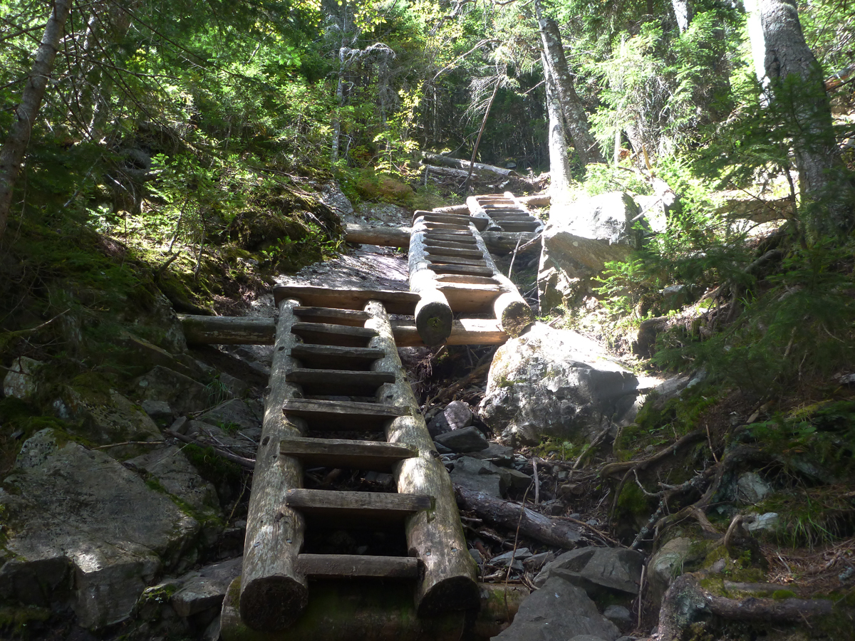
The new ladders. This is ladder #1 on the ascent. There are three sets of ladders on the trail. The original trail cut by Lowe followed, or utilized a rather steep land slide track. When I was a kid the view from Willey was superlative as were the blueberries. The view has grown in somewhat but still worth the climb.

Set #2.
In 1909 the Willey Range Trail was completed when a Mr. and Mrs. J. A Cruickshank cut a trail from Mt. Avalon over Mt. Field to Mt. Willey which connected to route from the Crawford House to the Willey House station. The 1920 AMC Guide to Paths in the White Mountains and Adjacent Regions refers to "former A.M.C. path" presumably the one cleared by Charles Lowe in 1878 and the "re-opening" of the "present path in 1906. (p. 286).
In 1909 the Willey Range Trail was completed when a Mr. and Mrs. J. A Cruickshank cut a trail from Mt. Avalon over Mt. Field to Mt. Willey which connected to route from the Crawford House to the Willey House station. The 1920 AMC Guide to Paths in the White Mountains and Adjacent Regions refers to "former A.M.C. path" presumably the one cleared by Charles Lowe in 1878 and the "re-opening" of the "present path in 1906. (p. 286).

Looking back down from the top of the 3rd set of ladders.
 A school teacher from Portland, CT. Her boyfriend was racing in the 100 mile Gran Fondo bike race out of Loon Mt. in Lincoln so she had 6 hours to fritter away. She looked in a generic guide book and decided on hiking Mt. Willey because the book said it was "moderate" and she wanted to see the views. As we passed just below the summit (she was on her way down) she rather stridently said, "This is NOT moderate!" She's right.
In the 1920 AMC guide mentioned above it says, "After the Ethan Pond Trail diverges to the L. (sign) a few rods of wet, boggy trail leads into the old path (this must be the original cleared by Lowe in 1878: Ed.) at the crossing of the Brook Kedron (last sure water). From this point the path is one of the steepest in the mountains, following for some distance the track of an old slide. The view from the summit will well repay the stiff climb." (p. 286)

In the 1920 AMC guide mentioned above it says, "After the Ethan Pond Trail diverges to the L. (sign) a few rods of wet, boggy trail leads into the old path (this must be the original cleared by Lowe in 1878: Ed.) at the crossing of the Brook Kedron (last sure water). From this point the path is one of the steepest in the mountains, following for some distance the track of an old slide. The view from the summit will well repay the stiff climb." (p. 286)

Looking due South from the top of Willey. Chocorua is in the distance on the right, Moat Mt. is center rear, Pequawket (Kearsarge) is the pyramid on the left horizon. Stairs Mt. center foreground, a ridge of Mt. Bemis, or Mt. Nancy, coming down on the right, Mt. Webster on the left. Route 302 winding through Crawford Notch below.

Same as above but add Doublehead on the left horizon left of Pequawket. The Baldfaces, two peaks to the left of Double Head, are visible. Route 302 down in Crawford Notch.

Mt. Webster with Webster Cliffs along with Double head, etc..

Mt. Washington center, northern peaks to the left, southern peaks to the right. Mt. Jackson and Mt. Webster.

Mt. Carrigain center, Hancocks to the right, Sandwich Range including Tripyramid in the rear.

Mt. Bond center. The Twins to the right, Moosilaukee to the left, Mt. Cube way in the back to the left of Moosilaukee. Lafayette and Lincoln behind the Twins. The Pemigewasset Wilderness, eastern lobe, across the foreground. It extends up an over Bond to the Franconias. Mt. Bond is close to the exact center of the Pemi.

Carrigain again in the center, with Whiteface in the left background.

View from Mt. Field: Mt. Jefferson and Adams to the right, the Dartmouth Range with Deception and Dartmouth left center in foreground (behind the Bretton Woods hotel), the Kilkenny stretching behind the Dartmouth Range with Waumbek and Cabot one ridge behind, and Mt. Pilot on the left in the background.

Quebec, Mt. Tom, Cherry Mt. Pilot center in the distance, then the Kilkenny area with Starr King, Waumbek, and Mt. Cabot, and, fianlly, the Dartmouth Range with Mt. Deception, left, and Mt. Dartmouth on the right.

Devastation on Mt.Field from either Hurricane Sandy (2012) or Hurricane Irene (2011). A micro burst not associated with either hurricane has also been suggested as the cause of this damage.

This is a good image of what it looks like after a high level hurricane although some have been worse than others.

Just experimenting with the afternoon light. The descent from the Field-Tom Col is, at first, in a brook bed consisting of large and medium sized rocks. It's a bit of a slog in places through a primitive forest-scape of dark woods. In 1965 I read or heard that there was a stand of old growth spruce high up on the northwest slope of Mt. Tom. Fred Steele and I explored the shoulder of the mountain for a few days but found nothing equating to "old growth". It was common in the 1960s to receive reports that someone had discovered some last remaining groves of ancient trees that somehow survived the logging, places like the Hancocks, Carrigain Pond, and the back side of the Carters, but the reports were unfounded much to my disappointment at the time. It would have been exciting to find a stand of red spruce 3 feet in diameter, towering above the nascent newer growth.

Experimenting with water and light. This brook was as cold as ice and perfect for pouring over one's head in quantity as a refreshing way to cool off.

Anyone? They're Hobble bush berries. These are the shrubs hated by bushwhackers and prized by moose that have the lovely array of white flowers early in the spring season.

One of the beaver ponds in Zealand Valley with Zeacliff behind.

Just the light. It's stunning.


The new bridge over the area flooded by beavers.

Group coming down after crossing all the way from Glencliff (southwest of Moosilaukee) in the past few days. They were at Galehead last night.

The end. Enjoy!
