The blue
line on the map represents my solo winter ski traverse, mostly bushwhacking
(not using established trails), across the Pemigewasset Wilderness in January
2000. I started at the bottom of the Greenleaf Trail in Franconia Notch (upper
left-hand corner of the map) and finished at Rt. 302 at the base of the Sawyer
River Road in the lower right-hand corner of the map. The black line is my
proposed, not-for-winter, bushwhacking traverse across the Pemigewasset
Wilderness from the town of Lincoln in the lower left corner of the map
to the top of Crawford Notch in the upper right corner of the map. I was
looking forward to doing it this year, 2012, but, most likely, will postpone it
until early next spring so this is just an update of what I've done so far and
problems I'm trying resolve. Both the solid black line and the dotted black
line in the lower left corner of the above map are proposed routes, with the
dotted line being an alternate route from the solid black line I was originally
going to follow. Confused? I'll explain it below.

This is a section of an AMC Franconia Region trail map from
the 1960 AMC trail guide. In doing a "test run" of my proposed route
a few weeks ago I discovered a problem that made me consider an alternative
route. Heading up the route, the solid black line out of Lincoln (lower left
part of map curving on the upper side of Little Coolidge Mt.) I found the
balsam firs and spruce unbelievably dense starting low on the north facing
slopes all the way to the ridge and between Whaleback Mt. and Mt. Flume. Trying
to push through in random spots was impossible. This is a common feature of
bushwhacking at elevatons close to "tree line". There are several
alternative bushwhacking routes to the ridge, however. One that caught my eye is
via the old Osseo Trail that was abandoned 45-plus years ago. You can see it as
a faint dotted black line leaving the Kancamagus Highway just east of Lincoln,
next to Clear Brook, and above the words "Branch" and "Camp
3" and it heads steeply up to the summit of Osseo-Whaleback Mtn before it
joins the Franconia Ridge Trail on the south side of Mt. Flume. It was replaced
in the late 1960s with the new Osseo Trail that plunges down from Mt. Flume to
the Wilderness Trail on the east side of the ridge (see recent trail guides).
On the first, greenish map I drew the heavy, dotted, black line to show the
approximate location of the old Osseo Trail. The description of the trail is
below (taken from pgs. 128 and 129 in the Appalachian Mountain Club's A.M.C. White Mountain Guide 1960,
copyright 1960).
I failed
in my first, cursory attempt to find the starting point of the Osseo Trail
and/or some remnant of it that would identify it as such. One problem is that
the terminus of the old trail is now a huge condominium complex that's part of
the Loon Mountain recreation area. I searched by walking uphill in back of the
condominiums and traversing east and west but was unable to find the trail's
entry/exit point. At any rate this article pre-dates the 11-17-12 article in
which I describe locating the old trail and successful ascending Mt.
Osseo/Whaleback. From this point this narrative will concern itself with the
topic of Bushwhacking, interweaving my own plans with the history of
bushwhacking that includes some history of trail building in the White
Mountains.

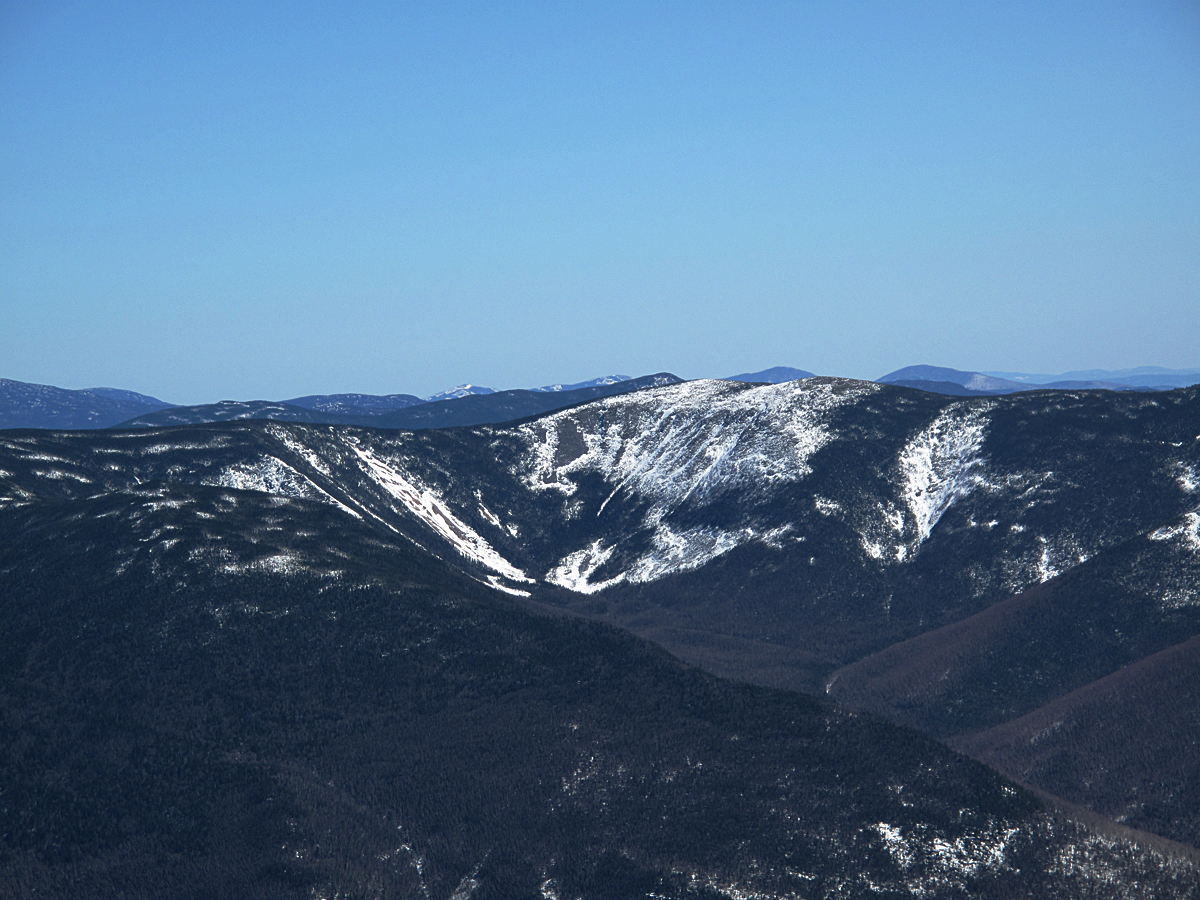
Looking into what has been referred to as a glacial
cirque in a story titled "Winter Climbing In the Pemi" by
Michael Edesess (June 1963 Appalachia,
p. 519 ). Unfortunately, it's not a cirque even though it looks like one from
some angles. At any rate, Michael's story includes some wonderful
descriptions of a week spent in the Pemi by his winter
hiking and camping group in the winter of 1963. They completed some
extraordinary bushwhacks including the Bonds from Redrock Basin and Carrigain.
It was his article that inspired my winter traverse-bushwhack of the Pemi in
2000. Redrock Basin, the large cirque-like bowl in the photo is located between
Mts. Guyot and Mt. Bond and there are no trails on this side. The usual
route(s) for bushwhacking are via the slides. In 2000 I went up the one on the
right which comes out on the ridge between Bond and West Bond. The slide on the
left, or north side of the basin, is also used to get up on the ridge to the
Twinway Trail.

Looking
down at Owls head from Mt. Truman (Truman is an unofficial name for the bump
between the summits of Mt. Lafayette and Mt. Lincoln) on the Franconia Ridge.
Mt. Carrigain is in the center distance. On my January 2000 traverse I skied
down the slide in the foreground and then skinned up Owls Head in a long
switchback. The skiing in the glades on the east side of Owls Head was superb
as it also was on the southeast side of Bond Cliff. Owls Head's an
interesting mountain geologically and ecologically. It's counted as a 4000
footer but there's rumors that it's just under 4000 feet asl. (Do not take this
as a fact! I'll get tarred and feathered. Due to precise readings from the
newest GPS technology it may be just under 4000 feet that still hasn't been
established. Owl's Head has always been a problem altitude-wise. It took years
to find the true summit and when it was located it was over 4000 feet, but only
barely. Almost all of the principle peaks, e.g. Carrigain, have had their
altitudes changed in the last 30 years.) That's Mt. Carrigain in the center
distance. Passaconway is the sharp pointed peak in the right background. I'm
including this photo to show the extent of the balsam fir growth on Owls Head
which makes it a really nasty bushwhack. I will have to find a good entry
point, an old slide possibly, to ascend from. You can see a few that might be
feasible. By the way, I'll talk more about the 4000 Footer Club, it's history,
farther on.

Looking over at North and South Twin, Guyot and Bond (and
myriad other summits near and far) from the top of Owl's Head in a photograph
taken by Miriam Underhill in February 1959. (Appalachia, June 1959, pg. 519) When this photo it was widely
believed that Redrock Basin and the basin below Bond Cliffs, on the right, were
authentic glacial cirques just like those on the Presidential Range. By 1961
they were no longer considered cirques but Miriam's photo illustrates why it
was so compelling to believe they were. The eminent geologist Dick Goldthwaite,
among others, reported that there was no evidence of an alpine glacier
occupying the two "bowls" and probably wouldn't because the bowl was
facing due west. If you look at the Presidential Range you will find no
westward facing cirques created by local, alpine glaciers because the
prevailing winds, according to theory, were out of the west so the bowls
wouldn't collect enough snow to form a glacier. I like the photo because it
shows the extent of the logging in this area and the altitude up to which the
loggers cut on the peaks 40 years, or so, before the photo was taken.
Miriam took the photo while bushwhacking up Owl's Head on a Winter 4000-Footer
club trip that included her husband, Robert L.M. Underhill and several others.
The Underhills completed their winter 4,000 Footers in 1963.

Bushwhacking up Owl's
Head, February 1963 (AMC Photo).
My interest in attempting the traverse has several facets.
One is simply for the adventure and another is simply getting closer to the
mountains as in knowing them better. I can hike on a trail and look down the
whole way without seeing anything, but bushwhacking requires paying attention.
You're more involved with the terrain. Bushwhacking requires a change of pace
along with getting away from people, the huts and all of those
distractions. On my recent hike up Mt. Whaleback (11-18-12) it was so
refreshing to spend a whole day in the mountains without seeing another soul or
hearing reminders of human activity with the exception of the drone of an
airplane flying high overhead. If your passion is to study the fauna and flora
then bushwhacking is far more rewarding than studying from the trail (with the
exception of areas above treeline where it's important to protects alpine
plants by staying on the trail, or walking on rock slabs).

It's still possible to
recreate the experience of navigating through
the mountains the way
early explorers had to before there were
trails, for
instance, by bushwhacking through the Pemigewasset
via Zealand and
Carrigain notchs and climbing Mt. Lowell.
In the earliest historical accounts of exploration in the
White Mountains bushwhacking was de
rigeur. Colonization of the New England coast by Europeans in the early
1600s triggered several attempts to explore what's now central and northern New
England by fur trappers, hunters, soldiers, fortune seekers, and land
speculators etc, who found themselves in a real wilderness, one we will never
see the likes of again on this planet. They bushwhacked or followed the network
of Indian paths that crisscrossed the Northeast threading mainly along river
bottoms and, for the most part, avoiding the high country. The Indians also
relied on birch bark canoes, a far more efficient means to travel utilizing the
myriad rivers and lakes of the Northeast.
Bushwhacking allows
you to get lost in the sense that you get
completely absorbed in
the activity, like a child at play, and the
pleasure comes from
stumbling on something new, a view, or a
stream with the light
shafting through the trees, or a rare plant.
A cascade (photo) in
Whitewall Brook in Zealand Notch, where
wildness and beauty
coincide. Following a brook is a good way
to begin learning how to
bushwhack safely.
The wildness of the White Mountains stalled settlement of
the north country for a century. You could go around them by heading up the
rich valleys of either the Connecticut or Androsgoggin Rivers which made it
possible for some homesteaders to settle north of the mountains, but they found
themselves the target of Indian raids. In the 1600s Indians from the north
raided coastal and inland settlements in the south, like Kittery, ME and
Deerfield, MA, and often took captives back north. The Indians followed the
larger rivers and moved easily through the mountains via what are now Pinkham,
Crawford and Zealand notches. In his Passaconway's
Realm (Univerity Press of New England, Hanover, NH, 2002) Russell Lawson observes that these
"captives were unwilling explorers of the White Mountains."(p. 21)
The Indians moved with astonishing speed making it nearly impossible to
follow them and because conditions were harsh some captive died in route, while
others chose to remain with the natives, and still others eventually returned
to their homes. Their experiences, though, demonstrated that routes could be
found through the mountains.

Mt. Washington, the highest of the White Mountains, was
visible to sailors along the Maine coast. They referred to it as the Christal
(or Chrystal) Mountain because it gleamed in the distance. It had a reputation
of being wild and unclimbable. Some said it was haunted by spirits of the dead,
but enticing, nevertheless, as it was also widely believed that it was covered
with valuable stones, jewels, and silver that made it "twinkle" as
Captain John Smith proclaimed in 1615. You couldn't ask for a better incentive
for would-be explorers.
The first written account of a successful ascent of Mt.
Washington was that of Darby Fields, in 1642, who is generally accepted as the
first non-native and European (he was Irish or English) to climb Mt.
Washington. The account of the ascent is third hand and found in the journals
of Massachusett Governor John Winthrop. The accuracy of the account,
particularly the date and route, of Field's ascent was often questioned. The
18th Century historian Jeremy Belknap of Dover, NH, using reliable information
he possessed, suggested an alternative narrative that Darby Field may have
summited Mt. Washington as early as 1632 with two companions, Henry Josselyn
and Captain Walter Neals. Belknap's suggestion has never gained much favor.
Darby Fields got to the base of the mountain, no mean feat
in 1642, by paddling a birch bark canoe up the Saco River from the Indian
village at Saco, on the Atlantic coast. He was able to get as far upstream as
the mouth of the Ellis River where the Peqauwket band of Abenaki had their
village. The historical account is he then bushwhacked up beside the Ellis to
what is now Pinkham Notch and climbed to the summit following another stream
(the Cutler River) to the steep, eastern ridge (Boott Spur), then across a
broad, flat plain (Bigelow Lawn), and up the cone to the summit (see
accompanying photos). He was accompanied by two natives, possibly from the village
at Saco. He did not find precious stones but returned for a second ascent with
several companions later that same summer, perhaps to look for valuable gems or
precious metals.
Looking southeast
across Bigelow Lawn to Boott Spur. It's likely
that Boott Spur was the "first summit" referred to by the earliest
climbers to attempt Mt. Washington.
Another view
looking due south towards the Sandwich Range
(on the skyline) across
Bigelow Lawn with Mt. Carrigain on the
left in the distance. The
next photo of the "cone" and summit of
Mt. Washington was
snapped from the center area of this photo.

Looking north across a nearly level section of Bigelow Lawn towards the impressive summit "cone" of Mt. Washington that was often referred to by
the earliest climbers as a "sugar loaf". A rock cairn, or trail
marker is in the foreground. After Darby Field's two successful ascents more
and more climbing parties followed taking the route Field had pioneered. John
Josselyn, a physician from England who climbed Mt. Washington in 1662 describes
the scene in the above photo as: "Upon the top of the highest of these
mountains is a large level or plain of a days journey over whereon grows
nothing but moss. At the farther end of this plain is another hill called the
sugar loaf, to outward appearance a rude heap of massive stones piled one upon
another and you may as you ascend step from one stone to another like a pair of
stairs, but winding still till you come to the top which will take a half day
and yet is not above a mile were there is also a level of about an acre with a
pond of clear water in the midst which you may hear running down, but how it
ascends is a mystery." (Lawson p. 20)(photo by Steve Neubert).

Looking up John
Josselyn's "massive heap of stones" and the summit.
The popular route for both ascending and descending Mt.
Washington, at least for 160 years, was Field's. One remarkable
exception was a party of milita scouts under a Captain Wells who climbed the
mountain on April 18, 1725 finding 4 feet of snow on the cone and the summit
bare of snow but covered with rime ice and solid water ice. Captain Wells wrote
that it was a "clear still warm sun shining day and but noon yet found it
so very cold we could hardly endure it and therefore quickly marched
down." Their route of ascent is not known, but Capt. Wells reported they
bushwhacked down Ammonoosuc Ravine heading south through what is now Crawford Notch
(Lawson, p. 24.)
Boott Spur in shadow with Mt. Pequawket in the background taken
from higher up on the Mt. Washington summit cone.
All parties, or those that kept journals that have survived,
make note of the extreme difficulties bushwhacking through the
"scrub" (the krummholz) found at tree line. Reverend Jeremy Belknap
recorded, "but the growth was so thick on top that my fatigue in climbing
as not repaid by an prospect (view) as I expected." Another, Nicholas
Austin, in 1772, reported, we "went through thick growth of spruce and
fir, about a man's height, difficult to get through they were so thick. They
diminished in height as we rose the hill." (Lawson, p. 59.) The best is
this quote "the trees, which ranged in size from two to ten feet high,
posed a particular challenge to the men, who were unsure whether to slither
through on their bellies or leap from tree to tree like acrobats."(Lawon,
p. 92.)
Another view looking south across the western side of Bigelow
lawn with Tripyramid and Sandwich Dome (among other peaks)
in the background, the headwall of Oakes Gulf and Mt. Monroe
(on right with patch of snow) in the foreground.
In 1784 Reverend Jeremy Belknap, the historian mentioned
above, journeyed to what is now Pinkham Notch and camped on the Ellis River
with a four members of the American Academy of Arts and Sciences:
Reverend Manassah Cutler, Reverend Daniel Little, and Dr. Joshua Fisher. The
group also included two Harvard College students and Colonel Joseph Whipple, a
local land owner. Their intention was to hike up Mt. Washington to gather
scientific data on mountain weather and plants. Cutler, particularly, was
interested in cataloging mountain plants and was taking great pains in carrying
up a barometer of good quality and a sextant in order to make accurate
observations that might help him calculate the mountain's precise altitude.
Cutler was passionately interested in what effect altitude and weather had on
the mountain's plants and, like Captain Wells 50 years before, correctly
identified the environmental conditions that cause "tree
line".
Belknap was ordered to return to camp by their guide, John
Evans of Fryburg, ME, (Evans Notch) because he was so overweight he was holding
the others back. Belknap, to his credit and with great disappointment, hiked
back down by himself to their camp making several important discoveries on his
way. He observed the pattern by which the spruce and fir trees, gowing so close
together, grew successfully on the thin soil on the steep flanks of the
mountains. He was quick to see that the trees, along with thick beds of moss,
were tenuously supported by a "scaffolding of roots" all of which was
covering a "mass of loose rocks" (Lawson, p. 91), or felsenmeer. He
found that the scaffolding would bend a little but supported his weight most of
the time. When he occasionally broke through the thin layer of soil he
"damaged his shins on the rocks below". He had discovered one of the
prices paid by those who bushwhack on the upper flanks of the higher peaks .

Bushwhacking terrain at lower elevation on Boott Spur.
Darby Fields and other early explorers of Mt. Washington
referred to the local Indians as too "superstitious" to venture high
up on the mountains although he seemed to have no trouble finding two who were
content to join him on his ascent. Some years later in the summer of 1781,
General John Sullivan of Durham, a friend of Belknap's, ascended the mountain
and had contact with local Indians. He observed that, "the savages are
sensible to the difficulties (of bushwacking in that terrain) and do not
attempt to climb it." (Lawson, p. 64.) Sullivan's remarks are probably a more accurate explanation than Field's. Thoreau in an essay on Mt. Katahdin
wrote, "simple races as savages, do not climb mountains--their tops are
sacred and mysterious tracts never visited by them. Pamola is always angry with
those who climb to the summit of Ktaadn." (Appalachia: June 1963: p. 525). Thoreau wrote that the sentiment of
the Indians towards the mountains was that "only daring and insolent men,
perchance go there." (Ibid) As perceived by these white men and early
travelers the Indians were a.) supersitious, b.) sensible, and/or c.)
respectful of their Creator. On his ascent of Mt. Washington in 1839, Thoreau
refers to the mountain by its local Indian name of Agiocochook which he knew
translated simply means "home of the Great Spirit" so it's safe to
say that local natives felt it practical to avoid the high ground with its
fickle weather but some held spiritual beliefs preventing them
from visiting the summit of Mt. Washington.
Looking west from the summit of Mt. Washington towards the
Mt. Moosilauke straight ahead in the distance, Franconia Ridge
in the middle distance, and the Crawford Path in the foreground.
John Josselyn in his first voyage to New England in 1632,
inspired by Jacque Cartier 100 years before him, made contact with the natives
in and around the mountains to collect information about medicinal plants. He
was particularly interested in what Indians used for common ailments like tooth
aches, headaches, upset stomach, kidney stones; the kinds of maladies known to
all humans, but had no known antidotes. Chief Passaconway of the Pennacook band
became famous as far away as France and Germany for his knowledge of medicine.
For a portion of his life he often was host to physicians from France, Germany
and Switzerland who, like Josselyn, wanted to find common cures for common
ailments. Jacque Cartier, while wintering near present day Montreal in 1535,
was losing his crew to scurvy until a local Indian, the son of the local chief,
showed Cartier how to make a tea from the inner bark of white spruce and
another made from the bark and leaves of Arbor Vitae that both cured scurvy.
When Cartier left Canada that spring he took back to Europe a list of more than
100 plants and their medicinal uses. He demonstrated the use of these plants in
France to show that the medicine of the natives in the "New World"
was far ahead of medicine in Europe.

The opening at the
top of Crawford Notch with Mt. Webster in
the background. The
Notch, used for millenia by local Indians,
was discovered by white
settlers in the 1770s and became the
main thoroughfare for
traffic from the coast to Canada and put
an end to a classic
period of bushwhacking in New Hampshire.
On the north side of Mt. Washington the rich lands
comprising the intervales of the Ammonosoosuc and Israel rivers were
being settled. Homesteaders had made their way north up the Androsgoggin
and Connecticut river valleys. A landowner and aristocrat, Joseph Whipple, who
was part of the Belknap-Cutler-Little expedition and, with the others, climbed
Mt. Washington, was able to buy up a great deal of land as did Ethan Allen
Crawford's father-in-law, in what initially was called the Nash-Sawyer
Location. In 1771 Timothy Nash had identified Crawford Notch as a viable route
through the mountains. It can't be said that Nash had literally discovered it,
but with Benjamin Sawyer's assistance, demonstrated that a horse and wagon
could be navigate down the notch to the satisfaction of the state's govenor who
rewarded them with a a huge grant of land north of the Notch. An interesting
footnote is a road was not constructed through the notch until the mid-1780s
and, in the meantime, John Evans had hacked out a rough road through Pinkham
Notch in 1774 that connected Conway with Shelburne (Lawon, pgs 52-57).

From the base of Mt.
Washington summit cone looking due west
towards Crawford Notch
with Mt. Monroe in the foreground and
the AMC's Lakes of The
Clouds hut just at the base of Monroe.
Mt. Lafayette is in the
middle distance.
Looking east to Mt.
Washington from the summit of Mt. Clinton where
the Crawford Path breaks out the krummholz and begins the long,
exposed ascent up the ridge and over Mts. Pleasant and Franklin
and on to the top of Mt. Washington in the background.
With the settling of Crawford Notch by Abel Crawford and his
family in the early 1800s and the growing reputation of Mt. Washington brought
on by the growing number of reports of safe ascents being made by reputable
people like Capt. Wells, John Josselyn, Reverend Jeremy Belknap, Reverend
Manassah Cutler, Reverend Daniel Little, Dr. Joshua Fisher, Joseph Whipple and
General John Sullivan, and the end of the Revolutionary War that brought with
it a growing nationalism. As this was happening more and more people were
coming to the mountains, many of them out of curiosity. Philip Carrigain,
the New Hampshire Secretary of State and Cartographer, in 1820, with a large party
of emissaries including Major John Weeks, visited Abel Crawford and
climbed Mt. Washington via the Crawford Path. As they went over each of the summits Carrigain
bequeathed each with its new official name: Mt. Clinton, Mt. Pleasant, Mt.
Franklin, Mt. Monroe, Mt. Washington, Mt. Jefferson, Mt. Adams, and Mt.
Madison. A boisterous celebration followed each of the christenings with long
draughts of liquor carried up by Ethan. They gave the larger of the two lakes
nestled at the bottom of Mt. Monroe the name "Blue Pond" that was
changed to Lakes of the Clouds in 1833 (June, 1964, Appalachia: Early Scientists in The White Mountains, p. 52).
Carrigain's name would soon be given to one of the most beautiful mountains in
the realm. The mountains were, indeed, becoming civilized.
End of Part I.