Sunday, March 20, 2011

3-19-11: Lakes of the Clouds

The summit of Mt. Washington clears briefly around 2 pm yesterday (3-19-11) after a morning of fierce wind, cold, snow and dense fog. Winter is far from over here!

I finally got up to the mountains and Lakes of the Clouds again after what felt like an eternity (three months!) and with great delight except for the discomforts of being grossly out of shape. The discomfort was worth it, though.. it was a lovely mountain day.

I'm beginning this piece with this photo after receiving a wonderful email from a young woman in California two days ago that read: "Dear Mr. MacPhail, Just wanted to say hello and mention that I stumbled on your White Mountain Sojourn blog tonight when looking for information about my grandparents, "Slim" and "Cal" Harris. Imagine my surprise when I found your blog with not only a description of their work on the Dwarf Cinquefoil project with Miriam and Robert Underhill, etc, but also your kind description and nice photo of Gramma. That photo was taken the last, or next to last summer I spent in the Whites with Gramma, so it brought back great memories. All the best to you, Sara."

Mt. Monroe with a plume of snow blowing off the summit.

Sara and I emailed back and forth and I mentioned I was planning a trip to Lakes on Saturday and she asked me to "say hello to Grandda", referring to Stuart K. Harris, who I knew and mention often in the blog as "Slim", a renowned mountain man, a wonderful character, botanist, writer, artist and teacher. He worked at Lakes of the Clouds in the 1930s and with his gorgeous wife, Calista or "Cal", and their two young children, ran Zealand Falls Hut the summer of 1945, at the end World War II. I was attracted to them both as a kid because of their openness and willingness to teach me about plants. In the early 1960s they collaborated with Miriam and Robert Underhill in writing Mountain Flowers of New England published by the AMC in 1966. Slim did most of the writing and drawings for the book, Miriam took all or most of the photos, and Cal did a lot of the collecting and keying of specimens. There's a small plaque dedicated to Slim bolted to a rock on the knoll above the large lake and I went there to pass on Sara's regards to Slim, admire the stunning view of Washington and Monroe, and eat a sandwich.

When I arrived at the Base Station parking lot at 8:45 am there were already 15, or so, cars parked and more were arriving. The weather forecast was a little sketchy mentioning clearing, cold, windy and the all-encompassing "Partly Cloudy". At 8:45 it was snowing heavily. Anyway, this cheery trio tore into the parking lot, hopped out of their car and were gone in a flash. I envied their speed and organization. It took me a half hour to suit up, finish packing and just move a few steps towards the trail. Even then I had to drop my pack a 1/4 mile up the trail and run back to retrieve my gloves which I'd left on the roof of the car!

Part of the half hour getting ready was spent in French lessons with this fellow, Etienne, who is a veteran climber and French speaking Canadian from Quebec. We'd started a conversation about weather and trail conditions, what equipment to bring, etc, but he spoke only a little English and my French is kind of like Michael Palin's in Monty Python and the Holy Grail (The scene at the castle where he says to King Arthur, "Of course I'm French.That's why I am talking with this outrageous French accent you silly king!"), but my French is not the least bit amusing.

Then Nichole came over to ask about weather, trail conditions, what equipment to bring, etc. She spoke a little English and translated for Etienne and I. Nichole was one of a group of 4, two couples from Quebec. Her companions arrived and then everyone was speaking French and my French began to warm up a tiny bit which was helpful later up on the mountain as half the hikers were French Canadian which is fairly standard these days.

Starting up the lovely, lovely Ammy.

Still lots of snow everywhere.

The blue blaze on the tree is usually 6 feet off the ground.

The track of the massive avalanche that occurred in Ammonoosuc Ravine in February 2010.
See "Blog Archive" on the right side of the top blog page. Open "2010" and scroll down to "March" and open 3-7-10, then in "April" open 4-5-10 for photos of the avalanche damage.

Gem Pool crusted with ice and snow .

Above Gem Pool the going is steep for a 1000 yards, or more. Most of us were wearing crampons but Nichole stubbornly stuck it out with snowshoes. The steepness is not exaggerated.

View to the northwest from the top of the Ammonoosuc Ravine headwall. The snow was letting up and it looked like the valley would soon be bathed in sunlight. The 2010 avalanche track can be seen in the lower right hand area of the photo.

There were sporadic breaks in the clouds. This is just above the treeline and looking across the upper realm of Ammonoosuc Ravine towards Mt. Jefferson.

Impartially cloudy. The Summit breaks through! (for a few minutes.)

The winter trail sometimes runs close to the summer trail, but often it kind of wanders here and there on the whims of the first person up after fresh snow. At this point the summer trail was a quarter mile to the right, but no one seemed to mind. When you can walk on top of the snow you can go anywhere. It's like a sidewalk without the cracks.

A few snowflakes were still drifting around on the wind but it looked like the main force of the weather was towards an eventual clearing.

Lakes of the Clouds Hut.

Etienne and Michel showing their pleasure with their hike. They were heading on to the summit of Mt. Washington from here. You can't tell by the photo but Etienne was giving me a thumbs up to express his contentment.

I headed for Mt. Monroe to look at krummholz and felsenmeer. I also wanted to spend an hour or two exploring around the larger of the two Lakes of the Clouds to take advantage of the hard snow pack that made traveling so easy.

Recognize this? It's a dense, high standing (5-6 feet) clump of krummholz (a mix of Black Spruce and Balsam Fir) that the Crawford Path cuts through just east of the Hut. I've photographed it numerous times particularly in the winter as a way to show how different the weather patterns are from year to year. Last winter this clump was completely enclosed in a cocoon of ice. As I hiked up Monroe on Saturday and walked around the lake I had the feeling that this winter is not the great snow winter that 2010 was. The amount of snow on this part of the mountain this winter maybe as much as 40 percent less than last year. It's likely that a lot of the snow that fell here has since blown over to the east side as the winter winds this season have primarily been out of the northwest.

The summer trail up Monroe was a bit icy but the wind was the real problem as it contributed to a wind chill factor of -17 degrees (F). From the rocky nub just uphill in the photo that's just below Monroe's lower, north summit I retreated out onto the southeast face and climbed to the summit ridge from there, but it was too cold even on the lower summit to remove my glove to take a photo.

A mat of Diapensia lapponica exposed to the weather on the southeast slope of Mt. Monroe.

The Monroe summit is to the left.

Monroe Flats from Mt. Monroe looking southeast into the Dry River watershed.

Looking east from Mt. Monroe towards Boott Spur.

I descended through deep wind drifted snow on the east slope of Mt. Monroe.

Looking southeast (again) across a portion of Monroe Flats and towards Boott Spur.

Thanks to Sara's grandparents, Cal and Slim Harris, along with Miriam and Robert Underhill working in collaboration with the U.S. Forest Service and the Appalachian Mountain Club (AMC) this unique protected site was created at "Monroe Flats" which contains a number of fragile, alpine plants. One of them, Dwarf Cinquefoil, that was mentioned earlier, is a rare plant that in the early 1970's was down to just a handful of individual specimens that were becoming fewer each year in this habitat where they had originally been favored by environmental factors for hundreds of years. The Dwarf Cinquefoil was put on the Federal Register of Endangered Plants. The site has been protected for 30 years. During the first years of protection Cal and Miriam along with AMC researchers and volunteers (myself included) re-planted hundreds of Dwarf Cinquefoil plants. More replanting has been done recently and in several other locations.

Nicole and Claudia (small specks in the upper center of the photo) followed my tracks up the east side to the col between the north and main summit of Mt. Monroe. The north summit is on the right. The snow pattern on Monroe is quite different than last year with much less snow on the east face. This is primarily accounted for by the fact that in the winter of 2010 the largest storms came in from the southeast.

Wind contributes to the formation of the rime ice that was everywhere Saturday morning. The low clouds earlier in the day were the second factor in the formation of the rime. Rime is a cross between snow and ice and made from tiny ice particles that form these feathery crusts on anything protruding above the snow surface. In this case the rime is forming on the snow itself.


This pattern is formed by a combinations of rime and wind blown, hard packed snow called "sastrugi" due to its shape. Sastrugi normally forms in layers in concert with the wind direction. Here the wind that created the sastrugi a few days before has decorated it with rime.

This pattern was uniform on all the snow surfaces around the hut. This is the knoll above the larger of the two Lakes of the Clouds, towards the east.

Looking back at Monroe from this enormous snowbank on the east end of the lake.

Rime clutches at a balsam fir.

Looking again at Mt. Monroe across the lake.

You can see the same pattern in the snow on top of the lake. The landscape looks very much like it has been sculpted by the wind but recent heavy rainhas also played a major role in the softened forms we see here.

Looking northeast towards Boott Spur from the surface of the lake. This lake is fed, to a large extent, by snow melt into June and the rest of the summer from water draining from the ridge in the distance which also borders Bigelow Lawn to the east. The water in this, the larger of the two Lakes of the Clouds, is astonishingly clear all summer. This is partly due to it's being fed by the huge volumes of snow that fill this glacially formed "pocket" on the ridge.

Standing water from recent rains covers the outlet of the lake.

There was actually a good amount of water sitting on top of the ice at the west end of the lake. It came to the top of my boots in some spots. It had not frozen but west and downhill from the outlet rain runoff from the lake froze repeatedly in thin layers resembling a large, multi-layered cake.

Rime contains a fraction, around 25 to 50 percent, of the water that is contained in an equal volume of ice. The percentage of water in ice is around 91-92 percent. But even the rime contributes something to the water table and it would be interesting to find out to what degree moisture from rime impacts the local vegetation. Ice and snow contribute most of the moisture used by the alpine plants here which have adapted to the habitat by flowering in late May and early June even with the high risk of a heavy frost, or a blizzard.

Melting ice and snow, and perhaps rime, contribute water to the mechanical process of freezing and thawing that causes the fracturing of bed rock in the formation of the felsenmeer blocks that I've been writing about. These photos show rime sticking handily to the mica schist blocks.

The wind forces both snow and the rime particles onto the rock and into cracks like this one where it has the potential to contribute to the fracturing process.

One could conclude that between rime and ice in its various forms, including this ice that froze on an incline following a rapid temperature drop after recent rains, that the slowly melting ice would be a more consistent source of water to aid in frost-fracturing mechanics. The melt water will find its way into even small fissures in the rocks, freeze and thaw in daily (or other) cycles producing the force that breaks the larger blocks from the slabs, breaks the larger blocks into smaller ones, and also lifts the blocks from the subsoil over vast periods of time.

There was an enormous amount of snow packed in around the felsenmeer as well as ice that froze as it flowed and coats everything, at least at the 5,000 foot elevation. The combination of rime, snow and ice offers a glimpse of how conditions for frost-cracking occur even though temperatures and amounts of precipitation vary enormously from winter to winter. It is also a glimpse of how felsenmeeer becomes more common in higher elevations.

As I got ready to descend the clouds were still brushing the summit.

and people were still arriving even though it was mid-afternoon.

A last look at the hut. It looks like a scene from the movie Dr. Zhivago.

And a last look at the summit.

Descents on this hard packed snow are a delight as you can run with abandon.

Two views of the Dartmouth Range. (Above and the photo below). My next project, in a few weeks, will be to bushwhack the length of the range beginning from the Jefferson Notch road and coming out on the Cherry Mountain road.


Light and shade among the trees along the lower stretch of the Ammy

and late afternnoon sunlight on snow.

True to form, it always clears up on the peaks just as you get down to the road!

Tuesday, March 8, 2011

3-8-11 Two more photos for a comparison of vegetation influx.

Here are two photos of Whitewall Mountain taken from Zeacliff that line up pretty even if not in perfect focus. I took the black and white photo in July 1982 and the color photo below on 9/22/07, so they're about 25 years apart. Like the Mt. Madison photos I posted last month that were 44 years apart, you could say the vegetation has not made significant advances over these relatively short periods of time, but there's an incremental increase in density, or a "thickening", of vegetation, e.g. measurable lateral growth on existing stems and branches in both sites.

Whitewall and the area around it to the north was burned in a massive forest fire in the late 1800s and again in the early 1900s. There is a lack of specific information of the extent of damage from the two fires but we know that the trees and soil were totally consumed in the area of this photo. In the 1920s a report in Appalachia lists 13 major slides on this side of the mountain. Regenerative growth did not get established until the early 40's. Like the south face of Mt. Madison, there are some environmental and ecological pluses and minuses for plant life on these steep, upland slopes where the soil is marginal. On Mt. Madison's south face there's a lot of sun, but little moisture. On Whitewall's west face there's an enormous amount of wind that funnels through the notch but a lot of moisture. At any rate, one would expect growth to be relatively slow on these sites compared, for instance, with plant growth down on the floor of Zealand Notch next to Whitewall Brook.

I've started measuring individual trees on a number of sites including their stem diameters, height, and the length of primary branches as part of a study to see what differentials in growth there are at higher and lower altitudes and in different soil regimes; near the tree line, on old slide sites, and in older growth in densely forested areas.

Monday, March 7, 2011

3-6-11 More Pix of Tuckerman Ravine as Snow Funnels Into the Bowl (in progress)


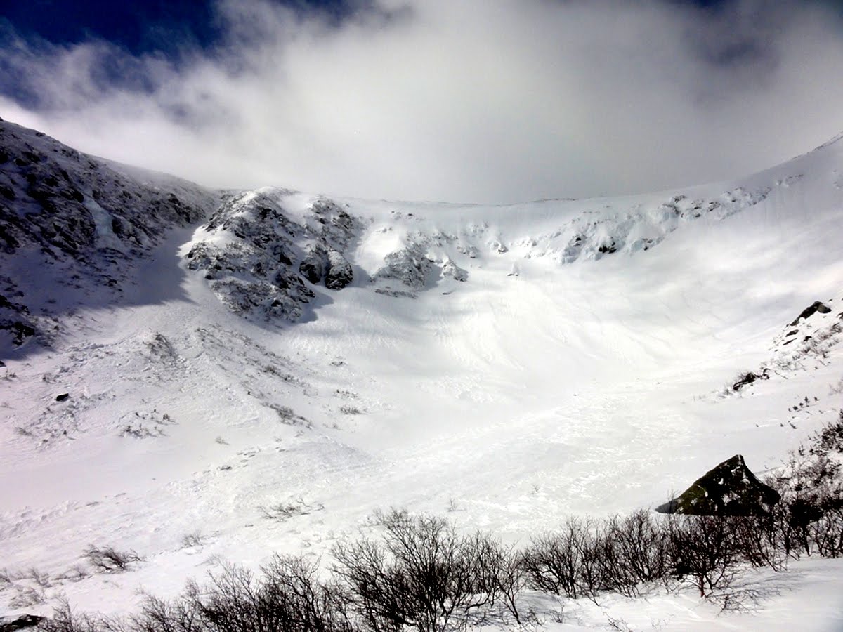
Rain is thundering on the roof and lacquering the storm windows as I write this (Sunday, 3-6-11) and just the sound of it, along with seeing two dead skunks on the road to Mt. Skinner the other day, are sure signs Spring is here. The sun is warmer, too, and the light has been lovely in the long afternoons. That's all good news to some, but in the mountains snow will be in the picture for some time to come; at least three more months. From these photos copied from the U.S. Forest Service's Avalanche Info website you can see how the snow in Tuckerman Ravine is piling up both from storms and drifting. Looking closely you can see tracks of "spillage": snow that come down into the gullys from above. As I write this it's snowing on the high peaks with more than a foot of new snow forecast for tonight and tomorrow morning. The depth of snow at the snow stake in Tucks is 63 inches (3-5-11), not much to write home about, but getting there. The photo above was taken on 2-23-11 and the ones that follow below were taken 3-3-11 and there's been visible buildup over the week.

Looking across the bowl from the Lobster Claw to The Chute. Lunch Rocks (Bottom center of photo) are nearly covered and the gradient of the slope indicates a good buildup of snow in the bowl already with more snow on the way.

Readers have been chiding me for not writing as much as I normally do and it's a sad fact that I haven't been North for the entire winter. Not since December 27th. So I'm chaffing at the bit to get up there. I'd planned a trip to Lonesome Lake for this weekend and was going to head up yesterday but the weather was really awful with sleet and rain and slush underfoot.

Looking up Left Gully and The Chute on the south side of the bowl.

In lieu of hiking I've been working on two projects for this blog. One is putting together a "key" with a comprehensive index for Appalachia, the AMC's esteemed journal, from 1910 to 2000. I've been thumbing through my collection of roughly 40 issues dating from 1928 to 1963 and listing all articles that are specifically about the White Mountains under various headings. The headings include Natural History, Animals, Birds, Plants, Geology, Glaciology, and Weather. Other headings include articles dealing with History, Trails, Huts, Science, Legislation involving the mountains, Swimming Holes, Research, Obituaries, Logging Railroads, Reminescences, Deaths, Accidents, Rock and Ice Climbing, and hundreds of Photos. I'll probably assemble it as a separate blog linked to this blog. That way it can be kept up to date easily and readers can add things they've found as comments. The index will be to the side. Issues will be in a chronological sequence by year and month with selected articles from each issue listed by title, subject and author. The index will list the title, author and subject separately in alphabetical order along with the specific issue they appear in. The draw back is that the articles themselves won't be available in the blog, just a means to identify the issue of Appalachia containing a desired article. What I might do is ask Becky Fullerton, the librarian at the AMC headquarters in Boston, MA., if it would be possible for people interested in an article to write or email her and receive by hard mail or email a photocopy of the desired article for a nominal price. The two complete sets of Appalachia that I know of are at the Boston AMC office (5 Joy Street) upstairs in the library and at the Highland Center in Crawford Notch, NH, upstairs in the library there as well. There are probably other complete sets with public access in other locations which I will try to identify.

The reason for all of this work is to open up Appalachia to everyone interested in the White Mountains for a multitude of reasons. Appalachia, after all, contains a vast treasure of vital and interesting information about the White Mountains and mountains across the globe, even detailed information about snow and avalanches, mountain medicine, mountain weather, ghost stories, lots of history particularly about famous expeditions to the far ranges during the past 120 years. So it's a great resource with great articles and stories meant to be read over and over again!

The top of The Sluice ready to be skied. Unfortunately the avalanche danger is high and probably will remain high for the rest of the week if a lot of fresh snow arrives Sunday and Monday.

My second project has been to identify all the aquatic plants photographed last summer that I'll photograph again this coming summer as I repeat research Lawrence Collins completed in the summer of 1965 of aquatic plant populations in Eagle Lake and Lake of the Clouds. As I looked through his thesis and the maps of the four lakes where we collected data I remembered the day we almost got arrested for flying upside down through Franconia Notch. Larry had a small plane, an Aircoupe, that was the Volkswagon Bug of airplanes. It's main safety feature was that if you got into trouble you flew close to the ground, jumped out and ran ahead of it and stopped it before it hit anything. It was an underwing aircraft so to take photos straight to the ground when making maps you had to roll the plane up so the wings were a little more than perpendicular to the ground. One morning we were photographing Echo Lake and Profile Lake in Franconia Notch to make an accurate map of the shoreline and we were up about 500 feet. Larry rolled the plane over and I shot several frames of Profile Lake hanging upside down. Out of the corner of my eye I could see some people at the Old Man of the Mountains viewing area looking up at us including a New Hampshire State Policeman. We continued down through the notch and then circled and came back through and took a few more photos before heading back to the Franconia airport located on the Kinsman Notch Road. We looked down and saw the state police cruiser, blue lights flashing, right below us. He was heading to the airport. We thought of heading to another airport but reasoned that it might be futile. After we landed we taxied back up the strip to our car and the policeman waved us over to where he was standing. We got out of the plane with our equipment and could see he was angry and about to yell at us. When he saw the cameras and lenses he calmed down a little and asked us what we were up to. We explained the whole deal and he let us go but we laughed about it for the rest of the summer.

This is the map of Profile Lake that Larry made from the photograph.

Monday, February 14, 2011

2-14-10 Aquatic Plant Studies Continued

This is a bit of worthwhile news in that I've been fortunate in receiving the original print of Lawrence Collins limnological study that included Eagle Lake on Mt. Lafayette and Lakes of the Clouds on Mt. Washington. I'm indebted to Marjory Collins, Larry's sister, for loaning me her only copy as I was unable to locate mine. The data contained is invaluable for future research regarding possible changes that may have occurred in the aquatic plant population of all the lakes we studied in 1965, but certainly the two alpine lakes. My foray this past summer into Eagle Lake and Lakes of the Clouds plus cursory studies of Lonesome Lake, Carter Lake and Zealand Pond (see Blog entries 7-27-10, 8-7-10, 8-8-10, 8-14-10, 8-15-10 and 8-20-10) will be the beginning of more in-depth (no pun intended) studies during the 2011 summer. So, thanks Margery for pushing onwards and getting this in the mail.

2-14-11 Snow Accumulations in Tuckermans Ravine.

Happy Valentine's Day! We're past Winter's mid-point and the snow in the ravines on Mt. Washington is blissfully piling up. The excellent photo above and the four that follow were all taken by the US Forest Service snow rangers after the large storms ten days ago and were purloined from the USFS Avalanche Information website. Above is that great view from the Huntington Ravine Trail looking back at Boott Spur. Hillmans Highway and Dodges Drop have yet to collect much snow. Snow Ranger Jeff Lane of the Forest Service posted "Moderate" avalanche danger on the Center Bowl, The Lip, The Sluice, and Hillmans Highway. "Low" avalanche danger was posted for Right Gully, the Chute, Left Gully, the lower snowfields and little headwall this morning (2-14-11).

Pinnacle Gully in Huntington Ravine showing avalanche debris at the bottom and a small section of the talus "fan" coming out of Pinnacle and Central gullies that is finally getting covered with snow. For 2-14-11 the avalanche danger in all climbing areas of Huntington Ravine are "Low" except Central Gully which is "Moderate".

Tuckerman Ravine. Check this with earlier photos. There's a lot more snow cover.

Looking up at the Lip (center) and the Sluice (center right) and if you look closely you can see a skier hiking up the sluice and some tracks coming down from the top of the gully.

Right Gully looks very appealing. So there's still 6-8 weeks of snow accumulation to come and snow depth is building steadily by all accounts this morning from Lonesome Lake (35"), Zealand Hut (48"), Carter Notch (43") and Tucks (52"), making a rough average of 4 feet of snow on the ground across the range between 3200- 3800 feet (Zealand's snow stake is at 2700 feet).

I've been sequestered here, in western Massachusetts, the past three weekends with work related stuff going on. It's been more than a month since I've been North which I find frustrating. I've done a bit of work on the blog. I finished the Moat Mountain-White Mountain Alkaline Batholith piece from 5-1-10. It's a good article and probably could use more tightening up but the story of the Batholith is really interesting and Marland Billing's role in the Batholith's coming to light is also fascinating. If you have some time you should go back and read it simply because it explains so much of what you see when you're on top of, say, South Twin or Carrigain, and you look around at the wide arc of the surrounding mountains. Being able to superimpose the Batholith (from 200-300 million years ago) over that image gives an enormously edifying picture of White Mountain history. Even the photo here of Pinnacle Gully relates directly to the Batholith.

Thursday, February 3, 2011

2-3-11 Let It Snow!

The following four photos were taken from the USFS link on the Mt. Washington Weather Observatory's (referred to as "The Obs") website. http://www.mountwashington.org/. The photos were taken on 12-28-11 (by either Brian, Justin or Chris). I'm using the photos primarily to show the rate and the means by which the ravines on the east side of Mt. Washington fill with snow. In the above photo you can see a lone climber, descending from Right Gully (right center of photo) and traversing across the Sluice; a tiny speck in the upper center of the photo. If you compare this photo with the photos I took 12-26-11 you can see increases in accumulation but mainly from the blizzard of 12-27-10. You can see the remnants of an avalanche in the bottom right of the photo. There has been no appreciable snow accumulation in the past two weeks as reported by the snow rangers. This is being written on 2-2-11 during yet another blizzard and Mt. Washington is expecting a foot, or more, snow in this storm. So stay tuned.

Looking across the "bowl" towards the lip and the Summit. There's appreciably more snow, maybe a foot, on the lower slopes than a month ago. Avalanche advisories are "High" on all trails and surfaces with the fresh snow from the storms of 2-1-11 and 2-2-11. The lone exception is the Little Headwall of Tuckerman's Ravine which is listed as "Moderate." Rangers are advising that, for the next few days, it's not safe even if you are only going up to look around. Meanwhile, the Obs is forecasting another storm which will bring more snow beginning late Saturday afternoon (2-5-11).

Huntington Ravine. Compared to photos I took 12-26-10 there has been little accumulation of snow to date. Odells Gully is in the center with Central Gully on the right.

A great shot of Pinnacle Gully (on the right with Odells Gully in the center of the photo). The talus slope below Pinnacle/Central Gullies is the main measuring stick for snow accumulation in Huntington and it shows, compared to photos from 12-26-10, only a small amount has been added during the past month. We'll have to wait for the photos from this week's storms to track significant changes.

Closer to home, the Holyoke Range got a total of about 2 feet of snow in recent storms up to 1-30-11 when this photo was taken. It's been such a wonderful winter thus far. I know there are some who probably get tired of the snow after back to back storms but I think it's really, really exciting.....

and I'm not the only one that thinks it's the best winter in ages. Snow boarders, a rare site on the Holyoke Range, were everywhere this past weekend.

Snow board tracks in the woods on Mt. Skinner.

Close up of Beech Bark Disease on a 12" dbh Beech on Mt. Skinner.