 The trail to Lonesome Lake was glowing in the warm, afternoon, July sunlight last Tuesday (7-19-10) as I and two friends hiked to Lonesome Lake Hut where we would be replacing the regular croo for a few nights while they went off on a much deserved vacation. The regular croo is made up of relative youngsters, probably all in their early 20s. Our team, consisting of Sue Dickman, who worked at Lonesome 24 years ago, Charlie "Chuck" Kellogg, who worked in the huts in the late 1950s, and myself, had an average age of 60 and between the three of us about 130 years of experience in the huts.
By the way, Lonesome Lake Hut is operated by the Appalachian Mountain Club (AMC) and is located at the western end of a chain of 8 huts extending across New Hampshire through the White Mountain National Forest. Lonesome Lake is located 1.3 miles above and west of Franconia Notch off Route I-93. The hut is at the south end of the lake. The distance from road to hut is 1.6 miles.
 We reached the lake and looked across to Cannon Mt., Mt. Lafayette and Franconia Ridge, and our senses told us that we'd arrived just at the height of summer on one of the most auspicious days you could imagine. It was warm and still, and the sky was a lovely blue. Sunlight glowed on everything.
 We quickly moved into the croo room and went over the brief instructions left by the regular croo about meals and guest counts, and checked out what needed to be completed in preparing the evening meal.
 A cookbook on the counter beckoned but all that was left to do was to prepare lasagna for 33 people--the number of guest who would be staying the night. The regular croo had already prepared the soup, the lasagna sauce, and.......
 ....four loaves of bread!
We had plenty of time to go out into the gorgeous afternoon and play for while.
 I headed right for the lake with my flippers, snorkel, diving mask and underwater camera to take a cursory look at the plants on the bottom of the south end of the lake and, once in the water, I followed a straight line from the dock to the center of the lake.
 One hundred feet out from the dock the water was around 10 feet deep. The lake gets a little deeper than that in pockets. This photo was taken in 9 feet of water and shows dense vegetation on the lake bottom. In the deeper section there was a little vegetation on the bottom and the make up of the bottom, itself, was a thick layer of mud-like silt, not slimy, which I could stick my had down into about a foot.
 This is the vegetation 50 feet from the lake outlet in about 7 feet of water.
 This is the bottom closer to the south edge of the lake in 5 feet of water. There is a current here due to the shallowness and the proximity of the nearby outlet and it's also the most accessible swimming area so there is probably a lot of 'foot traffic' here which would disturb vegetation. These factors account for the absence of vegetation. There are large and small rocks everywhere, in the littoral area as well as at depth across the lake's bottom.
 Sunrise on July 28th. Not a whisper of noise anywhere. Just that ephemeral, mesmerizing light silhouetting Mt. Lafayette and Mt. Lincoln!
Our first evening went well. We had 24 guests instead of the registered 33 so we had food left over including a whole pan of lasagna. During the next two days it was astonishing the number of hikers that came in the hut from every directions exclaiming, "heard you had a lot of left over lasagna." News certainly travels far and fast in the mountains but what's newsworthy about left over lasagna? Is that all hikers think about? Jeeez.
Charlie Kellogg gave a presentation that first night showing the guests a copy of the July 1961 National Geographic with the cover story: The Friendly Huts of the White Mountains, which put the AMC "hut system" on the map. Charlie is in a few of the photos in the article taken at Lakes of the Clouds Hut in 1960 (when he was still at Williams College) and he described meeting US Supreme Court Justice William O. Douglas who inspired the National Geographic story by visiting several of the huts that summer. Charlie has other claims to fame: he was a member of the US Olympic Ski Team in 1968 and competed at the Winter Olympics in Grenoble, France, he was a member of the American Biathlon Team in the 1960s, and is currently chair of the American Biathlon Committee.
 The Trillium in the woods around the hut that blossomed back in May and early June have matured and are about to drop their seeds. This seed pod (the ovary) is about to break open.
 This Trillium seed pod was nibbled by a mouse or squirrel and shows the arrangement of the seeds inside the pod. There are 12-15 seeds in each pod that are dropped in August and the plants' strategy includes possibilities of transport by birds and small mammals as well as water (run-off from rain) to spread them out a bit. The majority of the Trillium seeds will not travel far.
 The east side of the lake with Cannon Mt. (4050') in the left background and just a peep of the summit of Lafayette on the upper right.
 The west side of the lake with Cannon Mt. on the right, Copper Mine Col in the center and the first of the Cannon Balls, the rounded, smaller hump on the left. The lake covers about 12 acres and is a good size for an alpine lake. The elevation is only 2700 feet but I still think of it as an alpine lake (others may not). From various explorations over the years I calculate that the lake is shrinking in area by a small amount every year, mainly from soil deposits from mass wasting of the steep slopes to the north of the lake and vegetation increases in the northwest corner where most water influx occurs. By conjecture and observations of the thermal layers at the deepest part of the lake, it's likely that it's also 'fed' by a springs. (My feet getting icy cold at that depth is a reliable measurement). The 'deepest' point that I've measured is 13 feet but it's not conclusively the deepest. I doubt, however, the lake is much deeper than that.
 Looking straight across the middle of the lake to the west side. My area of interest for this short hike on Wednesday morning was the spruce swamp, actually a "sphagnous bog", where you see the dead trees on the opposite side. That's one of the points around the lake where fresh water enters from streams and annual run-off draining Kinsman Ridge (in the background) and Cannon Mt.
 The woods on the east margin of the lake are typical eastern boreal forest and are referred to as "mesic" meaning the forest receives a moderate, balanced amount of moisture. The forest here also receives a high amount of sunlight during the day and throughout the growing season. It also gets a lot of wind off the lake. The soil is moderately acidic but fertile with a thick A horizon that's rich in organic matter (humus). The succession stage is relatively stable even through hurricanes and major winter storms occasionally cause major blow downs that leave large opening along the ridge and near the lake shore.
 Ferns abound around Lonesome Lake including these Interrupted Ferns (Osmunda claytoniana) which thrive with the ample soil moisture and sunlight.
.
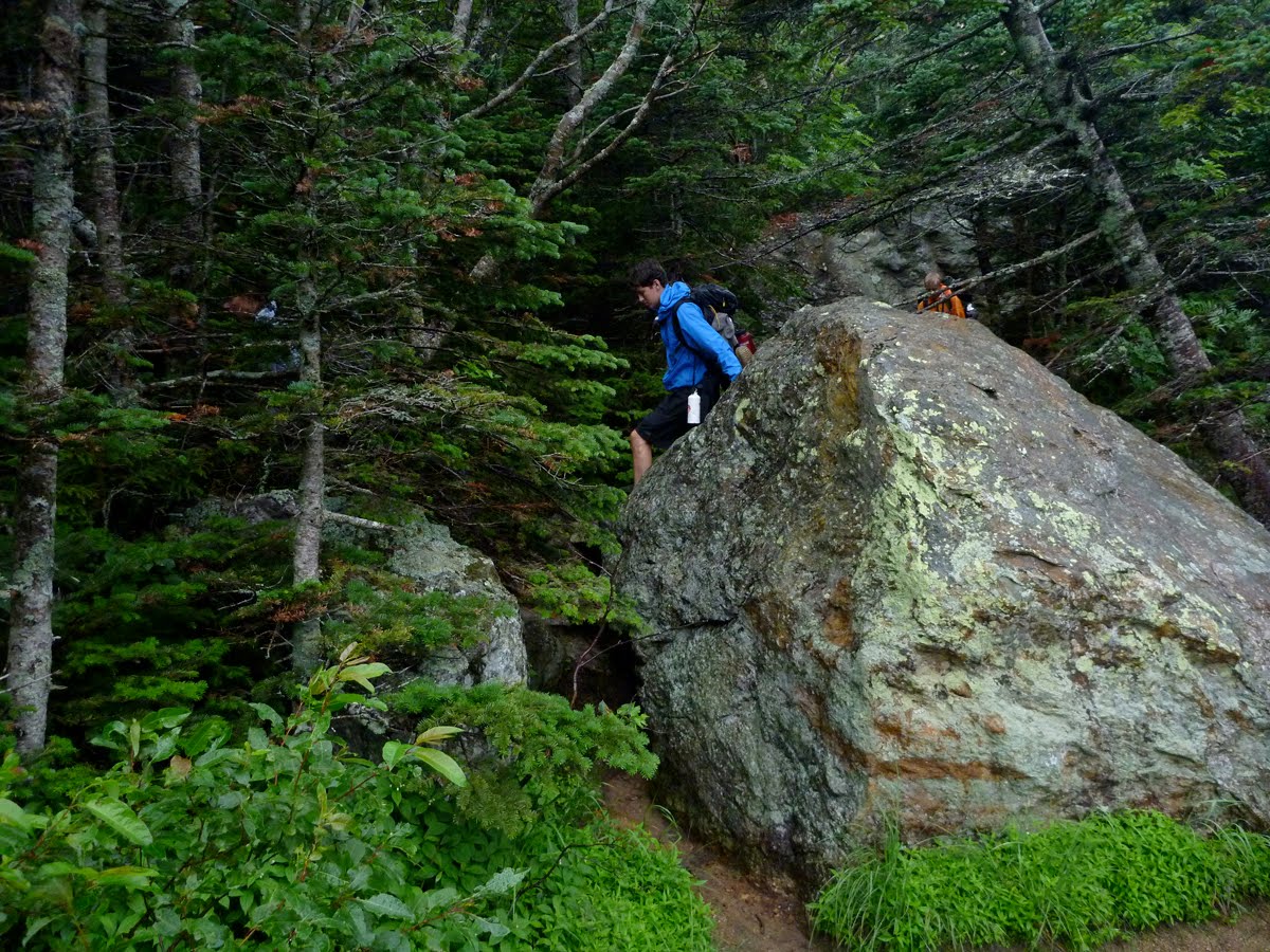
 This hiker ran up from the road to the hut as a morning exercise. During the last decade I've observed people who live within an hour drive of the White Mountain National Forest using it more. I've mentioned this before, particularly about Lonesome Lake which is a popular destination because of the short distance from the road to the lake. I like talking to the gaggle of visitors who visit the hut during the day and on Wednesday I met a memorable family, a father and four kids, who explained that they lived in Concord, NH, a 45 minute drive south of Franconia Notch. and this was the first he knew of Lonesome Lake. He said it was incredulous "how we live our lives and don't even know, aren't aware sometimes, of what's right at our doorstep." It's revolutionary if people who live in the shadows of the mountains and look at them all day get out and explore them on foot, too.
 The trail, which I will show more of in the photos that follow, now circumnavigates the lake in a system of boards and hewn logs that are elevated above most of the wet areas, a boardwalk of sorts, that offers a great resource for people who otherwise would not traipse off into the bogs peripheral to the lake. This photo shows the deep morning mood of the east side of the lake with the subtle mixture of light and shadows. It has a rich, sweet scent of the balsams and ferns and a morning coolness. In the afternoon it is a different place entirely particularly if it's sunny and there's a breeze from the lake.
 A height of land extends from north to south on the east side of the lake, a containment berm at the top of Franconia Notch, and it offers some protection to the lake and gives the feeling of being protected, in a way. The woods along this slight ridge are dry by comparison to the woods close to the lake, more open, and in flux with the balsams and spruces more or less dominant even though the white birch tries to compete. In those epochs when beavers populate the lake and the bogs at the northwest corner of the lake the white birch is there prime food in this area so many of them get cut down, even trees as large as 8 inches in diameter.
 There was a youthful group of volunteer trail crew near the north end of the lake that was made of up of teenagers who were putting the finishing touches on the trail system that circles Lonesome Lake. They were rolling this boulder into a hole dug in the trail which, when set, will offer hikers solid footing in what is otherwise muck.
 Fiona is the trail 'boss', an AMC employee with several years experience in trail building and maintenance.
 I arrived at their morning break and wished I'd brought over some of the left over lasagna. It would have been history in an instant.
 This young woman looks weary and definitely has issues about trail building which is really hard physical work. I asked if she was wishing she were somewhere else and she vigorously and emphatically nodded her head in a definite "YES".
 Sun Dews! This was the tribe of plants I was looking for: Drosera rotundifolia. I remember large colonies of them at various stations around the lake from the 1960s and wasn't able to find them for a few decades and now they're back. They're like Pitcher Plants and feed on insects that get caught in the sticky substance on their outstretched leaves. They are usually found in bogs growing in beds of sphagnum moss, like these. I'm going to take a leap and say they have an adaptation of changing their color to blend in with their surroundings as we will see in a few photos down.
 Looking south to North and South Kinsman Mountains and the hut. The original Lonesome Lake Hut was here, near this spot, originally built as a private hunting and fishing lodge in the mid-1800s (see photo below).
 This photo of the odd assortment of buildings that made up the camp was taken in the early 1940s. The camp was acquired for use as a hut from the state of New Hampshire by the AMC in the late 1920's at the same time that architectural drawings were being crafted for the construction of Greenleaf Hut on Mt. Lafayette.
When I first worked for the AMC in the early 1960s the hunting lodge was still the hut but it was at a point of decay where it was rapidly turning back into soil. If you dropped an orange off the kitchen counter it would roll very quickly right out the door. That's how badly the hut tilted. The present hut was built by the state in 1965. It's been remodeled and winterized since then.
 These are larch trees. They're also referred to as Hackmatack and Tamarack. The latin name of the American larch is Larix laricina. There are several species of larch world wide. They are found in mountain areas of Britain, particularly Wales and Scotland and in the mountain regions of western and central Europe, and Japan. You may recall that I reported having researched Larix laricina extensively. I was interested in it because it grows fast, it adds organic matter to the soil as the needles are deciduous and fall off every year (making it 'not' an evergreen though it's considered a conifer and is a member of the Pine family) and it grows in poor sites. Economically it does not have much importance so it's a hard sell but in Wales and Scotland larch has been used for reforestation projects because of their affinity for acidic soils and boggy terrain. I planted thousands of them in the Scottish Highlands when I was at university in Scotland. At any rate, I think they're attractive and like having them around.
 The larch's needles are a bit different then other conifers and in Grays Manual of Botany there described as "linear, soft, deciduous, very many in a circular cluster on the short spurs, developed in early spring from lateral scaly and globular buds."
 The larches are clustered at the north end of the lake and around the inlets in the northwest corner where the ground is wet the "bog" has been established over a long period of time. The ground cover inthe foreground and along the lake margin here includes sphagnum moss and Sweet Gale (Myrica gale), a shrub common to bogs where it grows 2-3 feet high in dense thickets.
 Heading towards the bog from the north end of the lake in a zone populated by Fir Balsam and a few of the larches. The walkway (boardwalk) was recently completed in this section and it has made a vast improvement in navigating the loop around the lake.
 At the northwest corner of the lake, in the shadow of Cannon Mt., and 100 yards back from Lonesome Lake and perhaps 6 or 7 feet higher than the surface of the lake is this large pond formed by an old beaver dam. In the fall of 1978 when I was the Lonesome Lake Hut caretaker there was a lot of beaver activity all around the lake. This dam was created at about that time. I used to row over quietly in the evening (in a boat) and watch the beavers in this pond. There was also a family of beavers in Lonesome Lake and by the end of the fall they were so accustomed to me they would swim over to the boat, if I sat perfectly still, and crane their heads up to look at me. The state hired a local trapper in the late fall of 1978 to set a number of beaver traps around the lake which drastically reduced the beaver population. It's never recovered from the culling.
 This pond is a catchment for a brook coming down from Coppermine Col, on the right, and all runoff draining from Cannon Mt and the ridge. All of that fresh water comes into this pond before draining into the lake and the pond insures that the lake receives an even flow of water from May to November which is possibly why the beavers built the pond, as insurance that the water level of the lake was fairly consistent. A secondary and direct effect of this pond is the presence of the extensive bog that occupies this site between the Lake and the ridge.
 The beaver pond, itself, is becoming part of the larger bog, and as you can see it's quite shallow. The beaver lodge in the background has not been used for decades and the extent of the back flooding from the pond has drowned the spruce and balsam fir trees in the background. Plant life is vigorously taking over the pond along it's entire margin.
 The list of plants one finds in a bog is extensive. This entry will only include a few of the most commom ones like this Mountain Holly (Nemopanthus mucronatus)
Everyone who writes about sphagnous bogs starts by saying how interesting they are because they're unique in many ways and usually foster a diverse number of plants and animals. There are usually a lot of the plants we call the "Heaths" (with the family name: Ericacea). Most upland, sphagnous bogs have upwards to 15-20 members of this family. The name, Sphagnous Bog, refers to the ubiquitous presence of sphagnum moss. In some places, such as northeastern Canada and the Highlands of Scotland they're referred to as "Heaths" or "peat bogs". In Scotland, the dense, thick, black, underlayer of peat is cut out of the bog, dried for a season, and burned in the fireplace, like wood, as heating fuel. The bogs have been and continue to be maintained specifically for the production of fuel. In Canada the bogs are maintained for the production of "peat moss" which is exported to the US where it is extensively used in horticulture.
 This could be either Spirea latifolia (Meadow Sweet) or Hardhack (Spirea tomentosa). They're similar except for the leaves. The leaves of S. latifolia are soft and smooth and those of Hardhack are slightly 'furry' (tomentose) on the undersides. The leaves of Meadowsweet are described in Gray's Manual as "coarsely serrated" and you can see they are in this photo. The flower clusters of the Meadow Sweet are more conical than Hardhack. With this specimen there's a pink hue in the flower petals which leans towards Hardhack. I settled on Meadowsweet, though, because of the leaves.
 Bog Goldenrod (Solidago Purshii) is like a neon exclamation mark in the bog. It's distinguishing features are the long, upright spike of flowers and the long narrow, lance-shaped leaves. The leaves are the best way to tell this from Mountain Goldenrod and Rough Stemmed Goldenrod which might also be found in a bog at this elevation (2700').
 I'll let you guess this one, but remember that there's three species of this much desired plant in the bog. They are belong to the Heath family and we find them in many habitats including on ledges at higher elevations than the Lonesome Lake bog. Choosing the correct one is based on a few small details including the shape of individual leaves, and whether the the "margins" of the leaves (outer edge of the leaves), have 'teeth' or not. If they have no teeth then the edges are "smooth". Leaf shape, texture, size, and the leaf margins, whether they have jagged teeth, slightly serrated, or smooth, are keys used in identifying plants. The flowers, too, are used to key out plants including the color, the number of petals, number of stamens, and size.
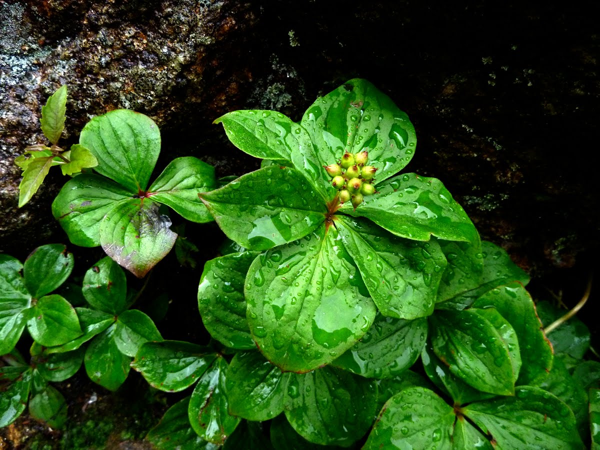
 A Cornus canadensis (Bunchberry) with ripe fruits indicating that it's almost August. The berries are edible but tasteless and a little waxy. Animals love them. Notice they have 4 leaves directly opposite each other. The berries' bright red color didn't register well on my digital camera. I'm not sure why but it makes them look 3D.
 This is the Drosera (Sundew) once again only distinctly reddish in color. It varies between green and this shade throughout the range and my belief (meaning I'm not sure) is that it changes colors based on it's surroundings, an adaptation that the Sundews use as a camouflage to fool its prey which are tiny insects. Sundews and Pitcher Plants which are also carnivorous are common in bogs.
 The Sundews are usually found growing in the large beds of sphagnum moss in open areas. They're tiny and you have to look carefully because they do blend well into their surroundings.
 Juncus brevicauatus (Short Tailed Rush). This is a common rush throughout the White Mountains and easy to identify with its rounded stem which differentiates it from the sedges. Just stroke the lower part of the stem of a leaf with your thumb and index finger and feel the round shape. In the sedge family the stems are triangular in shape. The rushes and sedges are common to bogs but grow in the area of the bog that is close to open water.
 Looking northeasterly from this location on the boardwalk there's a screen of larch trees with the Franconia Ridge behind them and a lot of vibernum (Carprifolicacea, or Honeysuckle family of which there are at least 2 species in the Lonesome Lake bog) and heath plants in the foreground. Bogs are usually open areas but with clumps woody plants like Labarador Tea and trees that are haggard looking and stunted like larch and black spruce. These trees have acclimated to the bog but actually do better in other types of habitats. This is true for many bog plants.
 Stepping back and little and looking due east towards the lake gives a perspective of the large part of the bog that makes up the northeast margin, almost a bay, of Lonesome Lake. It may have been an extension of Lonesome Lake hundreds or thousands of years ago. Another word for bog is "muskeg" which is described as a "non-productive" (low nutrient levels) bit of ground with highly acidic soils, that's wet and spongy in places, (with clumps of dead or dying conifer trees, and impossible to navigate." The two important characteristics of a bog are the high acidity and related low availability of oxygen in the soil. Bogs form where water slows down and is kept in the soil by the poor drainage.
 Looking back up at Cannon Mt. northward. It's likely that a successional cycle of forest-to-bog to-forest gets repeated many times over 5000-6000 year periods, but there are also bogs that have been around that long without going though a succession.
I saw lots of people using the boardwalk on Wednesday morning including this trio who were not particularly enthusiastic about being there. I think that navigating the boardwalk required all their concentration. To the left is another of those White Pine (P. strobus) that try to get their pictures taken in places slightly out of their range such as high on the Gale River Trail and the ledges at Zealand Falls. The bog is an uncharacteristic site for a White Pine as they generally like well drained soils.
 Other mammals have been using the boardwalk, or trying to including the moose that left this fresh pile of poop next to the boardwalk.......
 .......along with footprints in the mud beside the boardwalk as well as...
 several muddy hoof prints on the boardwalk where it tried to walk on the boards rather than get it's feet wet. The Lonesome croo reported a large bull moose is seen around the lake and near the hut. They said there are two different factions divided over a proper name for the moose. The more popular name is "Angus". The other suggested name is "Edmund".
 This bright red dragon fly used the boardwalk for a brief respite. Dragon flies are ancient insects and prized for their huge, steady diet of mosquitoes and mosquito larvae. Dragon flies are an important food for birds. I remember as a young child being absolutely terrified of them but, despite their looks, dragonflies are harmless.
 A red squirrel left this "midden" which is basically the inedible portion of a quick lunch on the boardwalk.
The bog does not end crisply. The edge is blurred by a successional zone where the plants, soil, and "character" of the ecosystem changes in minute gradations into the mesic, eastern boreal forest. The lead factor is the substrate which probably shifts towards the south of the lake and generates soil with more nutrient in the form of minerals and better drains better.
 Here you can see the forest returning, actually moving inwards towards the bog. This is the process we saw around the older beaver ponds and dams in the Zealand Valley that is also incrementally occurring in Lonesome Lake: the eastern boreal forest is the final shape of things to come even though it's always evolving, adapting, and moving through several dimensions simultaneously.
 Moving southward on the western shore of the lake the bog is still intact at the halfway point although the primary vegetation is changed to red and black spruce, fir balsam, a lot of heath including Labrador Tea (Ledum groenlandicum) and (Low Sweet Blueberry), (Vaccinium angustifolium) (in the photo above), which are two plants we've also seen in the alpine zone. The heaths include plants with edible fruits like blueberries, huckleberries, and cranberries.
 This is a red spruce growing next to the lake and shows another detail of the bog,
 This is a typical scene on the west side of the board walk, away from the lake, with the dense clumps of Labrador Tea, and the dense clusters of spruce and balsam fir. This landscape indicates the southern most boundary of the bog.

 On Thursday morning (7-29-10) I ventured back to this point on the board walk and donned by snorkeling gear to explore the underwater world of the bog.
 My jumping in spot was this small estuary that leads from the beaver dam already described out to the lake through thickets and small islands over grown with heaths, sedges, and small delicate plants like the Sundews. Sphagnum moss covered the remaining ground like a carpet.
 The water was colder than I expected and as I stood there questioning my will to submerge myself this female Mallard duck plopped down on my head, glanced off my left shoulder and landed in the water with a "quack". For most of the morning she tagged along with me eating constantly from the buffet along the banks of the inlet. She has a brood of three ducklings that she leads around near the dock and has become accustomed to humans.
 The bottom of the inlet/estuary consisted of a hard packed "floor" of glacial till covered by a thin layer of the particulate organic material that's loose (not dense) and "feathery".
 There were several of these channels that are formed by enroaching vegetation that's colonizing this part of the bog and moving into the lake itself. The colonization is random but the vegetation is most successful where average water depth and the sediments on the bottom are best suited. This has created a mosaic of small and larger "islands" or clusters of vegetation that consists primarily of heaths.
 As I snorkeled down the inlet a large school of fish, brook trout, tried to swim around me and some struck me in the shoulders and face. One struck my face mask so that we were eye to eye for a millisecond. The fish startled me by their sheer numbers, there were probably 20 or more, all trout and the largest one, by a rough estimate, was about 7 inches long. They passed by me a few times in a panic and it was clear that they preferred the cooler and safer upstream water of the estuary more than the lake. They were too agile to get photos of.
 The mouth of the inlet I snorkeled opens into the lake through this transition area of small islands. The islands are covered by the velvety sphagnum which comes in several hues including a gold-yellow, and crimson as well as the standard green.
 This is a representative photo of the "muskeg" that's formed on the lakeside of the bog with the clumps of stunted larch and spruce trees growing on hummocks and surrounded by water and a variety of sedges and rushes.
 Along with the fish and the occasional human the moose in the area like to travel along these estuaries and, in this photo, you can see their hoof prints, heading towards the lake.
 Moose hoof-prints, in fact, are everywhere around the lake including near this inlet and bog area that is covered with orchids.
 The ground in the areas of vegetation as in the photo above and this one is solid underfoot but spongey and I would discourage anyone from walking in these fragile habitats. Walking in the water would be preferable by the water is cold. This is a large population of Hare's Tail
 This particular view towards the northeast corner of the lake is the almost the same view as the photo below it which shows a set of builds that resided here for nearly 100 years and that were removed 40 years ago.
 This is the smallest of the islands I saw and the furthest out in the lake so it may be the most recent to appear. The sphagnum moss is a bright yellow.
 This is what the island looks like underwater. It's tenuously rooted to the bottom of the lake but positioned to promote further growth and to continue colonizing.
 I ran out of time and headed back to the board walk by a different channel. There weren't any fish in this one and the mallard had also gone off somewhere, presumably to tend to it's brood.
 The bottom along the channel was firm, the same gravel till, and covered by a thin layer of the organic sediments.....
 ....that creates opaque clouds when stirred up.
 When I reached the boardwalk, speaking of clouds, it had become quite dark and I looked up to watch for a moment as a cold front moved rapid through the area. It was quite dramatic. This is looking up at Coppermine Col with Cannon Mt. on the right.
 Looking northeast towards Mt. Lafayette.
 Looking due east.
 Looking south. It was a spectacular few minutes!
 My small venture into the bog was an opportunity to look at some of the dynamics between the bog and the lake and the process of succession. I want to come back and take time to look at the details. An important piece to remember is that these systems, or processes, represented by the bog, the lake, the forest, etc, , are multidimensional, in constant flux, and are nonlinear. Humans like to construct frames of reference (hard edged concepts) for looking at things outside of ourselves and try to be objective, but as we are slowly learning, we make mistakes constantly AND in that piece we lose a lot of the richness. Things are not always what they seem and there is definitely beauty in that expansiveness. If we could only be comfortable admitting we don't know things (when we clearly don't know) and not get anxious about it.


