Friday (5-28-10), another dreamy mountain day. You could see for miles and miles, the light was brilliant, and the colors lovely. This is a view from the Crawford Path (CP) just below the summit of Mt. Washington looking west at the Willey-Field Range, the Twins-Bonds Range, and the Franconias (with Mt. Lafayette the highest in the middle distance). Mt. Moosilauke is the high peak in the photo's center behind the Franconias and then there are the mountains of Vermont and New York. The clouds, the colors, the warmth in the air are indications that the "high days" of summer are almost here and that brief, anticipated season has just begun (even though it's still officially Spring). When I started up the Ammy earlier Friday morning the water in the river was lower and it sounded a bit more sedate but the birds were going bonkers, their songs easily drowning out the river.

I'm reusing a few photos from last week like this one of the snow patterns on the summit cone to show what has changed in one week.

This is what the snow patterns looked last Friday (5-28-10) at 10 am (by 5 pm the areas of snow were smaller still). I would make the observation that in terms of volume (not just surface area) that approximately 50 percent of the snow present last week has melted in the interim on the Ammonoosuc Ravine Trail as well as here on the ridge. Note the tapestry of fawn-colored "lawns" across the ridge and the summit cone that I want to explore a little along with some isolated clumps of Balsam Fir and Black Spruce growing just below 6,000 feet in two locations on the cone.

These are two 'cushions' of Diapensia lapponica photographed last week near the hut.

And the same two cushions photographed this past Friday, a week later. It's difficult to see the shiny coin in the center of the photo, a quarter (25 cents) in US currency but I placed it there to give some idea of scale to the diapensia blossoms.

This is how the small plateau just above the hut and below Mt. Monroe looked a week ago.

And this is the way it looked last Friday. If you click on the photo to make it larger you will see that the table is covered with diapensias. It's an amazing transition in such a short period of time.

Diapensia lapponica close up. The blossoms are about 1/2 an inch in diameter.

This is a cushion that was also included last week that is growing on rock in what would be described as a well-drained, or dry, site as compared with the two diapensia plants in the photogaph above which are sitting in a slight depression that collects water after rain, etc, and so theirs could be a more advantageous site. My guess is that the diapensia, because of the construction of the "cushion", holds on to available moisture well and thus is more versatile. The cushion is made up of hundreds of individual Diapensia plants.

Lapland Rosebay (Rhodendendron lapponicus) was also in bloom last Friday,

as were the Alpine Azaleas (Loiseleuria procumbens). These three plants, the Diapensia, the Rosebay, and the Azalea are spoken of as "circum-polar" and at the southern tip of their "range". This means they are native to polar regions and grow on the northern Presidential peaks of the White Mountains due to the arctic-like climate. Within the parameters of the present climate regime the areas of the Presidential Range above 5,000 feet are arctic-like, a unique island that easily support these plants that are more than a 1000 miles from "home". The concept of range (distriubtion) is an interesting ecological discussion, but these three species obviously do well here and have probably been here for millenia. I've heard a formula applied that for every 1000 feet of altitude one ascends in the White Mountains is the same as traveling North something like 200 miles in terms of the climate and ecology.

Rosebay and Diapensia together photographed near Lakes.

Added to the delight of all the flowers blooming was hearing this White Throat Sparrow (Zonotrichia albicollis) break the silence with its evocative mating song. The white throats race through the White Mountains every year at this time on their way to the arctic where they raise their young. They pass back through the White Mountains in late summer but go almost unnoticed because their song is less iconic. The mating song, or call, that makes the white throat easy to identify has been described sounding like the phrase "sam-peabody-peabody" sung rapidly in a falsetto voice. It's commonly six notes with a base note, maybe an E flat, followed by five quick notes a little higher in register. At any rate, it's an umistakable, lovely sound to hear drifting across the lawns and ridges while you're hiking.

The world famous Dwarf Cinquefoil (Potentilla Robbinsiana)! This is an individual plant I've photographed a lot. It's close to the trail so I don't have to tramp across other plants to get to it. In this photo, at this stage of development, it's a little smaller in diameter than a quarter (a 25 cent piece) so its tiny. I also found small, emerging Mountain Avens (Geum peckii) plants near the P. Robbinsiana.

Diapensia and Rosebay together in another photo which was meant to underline how "brittle" the area around Lakes of The Clouds "felt" the other day. In other words, the ground and vegetation seemed unseasonable dry even after all that snow.

Even the small tarn off the Crawford Path was nearly empty. A chain of hot, sunny days maybe the direct cause of dryness and will most likely be remedied by a day of rain and fog. The flowers, for the moment, don't seem to be effected.

Off to the summit! It was a stunning day and comming up the Ammy I had passed only one other hiker. Once on the ridge I had the saddle around the hut and the lakes all to myself for an hour and under those conditions it made a trip up to the summit attractive.This was a snowfield about a 100 yards wide just above Lakes of The Clouds Hut that's probably melted by now.

Higher on the ridge along the Crawford Path with the summit cone swathed in shadow.

A Wolf Spider. I was finally able to get a photo of one that's in focus. It's in the genus Pardosa, which includes the thin-legged Wold spiders. Bliss (1963) cites an older article published in 1940 by Alexander on the insects of Mt. Washington that lists 6 species of spiders in the Pardosa genus on Mt. Washington. This one may be a P. saxatilis.

Can you see the spider in the sedge? Although you become aware of the small black spiders when they scamper across the flat stones on the trail directly under your feet there are actually myriads of them in the lawns right next to the trail where they blend in quite nicely and are less likely to make a a lunch for a white throat sparrow .

This was the best photo I was able to get. They do move rapidly and with a point-and-shoot digital camera, without a view finder, it's a little tricky. This one actually posed for several seconds which made it easy. I think this is and the one above is P. lapidicina which is commonly found "running swiftly over rocks on talus slopes". There's a longer narrative that will be postponed for now about how they survive in this arctic-like environment.

These are the kind of looks you get from passing hikers when they come across you down on your knees next to the trail, camera in hand, shrieking at a spider to stand still for a second.

The steep south face of the summit cone 100 feet above the junction of the Crawford Path and Westside Trail showing an assortment of lawn, boulders/rocks/and smaller, scree-like rock fragments amassed here and making up a large percentage of the surface area of the alpine zone.

Still higher up the south side of the cone the photo shows the huge flake-like slabs of Littleton Schist, some of them with sharp edges, that attest to the enormous variety in the size and shape of what is referred to as the "felsenmeer". After all this talk about felsenmeer in the blog you may be amused by an encounter I had at a Spring Reunion of past, present and a few future hut croo where I was talking to Joel White, who managed the huts in the 1970s and worked around and on Mt. Washington for many years, and mentioned 'felsenmeer' and some of the mysteries surrounding it's origins and Joel remarked, "to tell you the truth I don't know what the hell felsenmeer is!" So I explained it and he said, "I thought all of those rocks were made by intense frost." Anyway, I laughed because he'd condensed many pages of writing into a simple sentence accurately describing the felsenmeer.

The west side of the summit cone, the area that faces the prevailing wind, has a higher ratio of lawns to felsenmeer. In most cases the lawns are surrounded by boulder fields, or else rocks are incorporated into the lawns in what Goldthwait described as "block nets", "block stripes" and "block lobes" to differentiate between patterns of rock configurations which he observed are determined by steepness of the slope.

A little to the right of the above photo and this shows large areas of boulders in random patterns broken up by lawn fragments all the way down the slope to the Ammonoosuc Ravine headwall.

More to the right and standing in the same spot as the above photos and looking northwest and showing more of the same tapestry of rocks-lawns and in the foreground you can see details that show the rock areas, like the rocks on the south side of the cone, are a vast, jumbled mass with a diversity of sizes and shapes.

Then, a little higher up on Crawford Path about, 500 feet below the summit, there's another broad lawn that slants steeply upwards to a large mass of boulders that's conveniently in shadow. You can see this rather random pattern of rocks-lawn-rocks in a wider perspective in the fourth photo down. From a distance the pattern looks like there's a higher ratio of lawn to to areas of rocks the closer you are to the Ammonoosuc Ravine headwall. If that's accurate it could be due to several factors and, of course, wind would be the more relevant one.

In the transition zone between that broad lawn and the boulder area I found this balsam fir (A. baslamea) forming a mat in a protected site about 100 yards west of the Crawford Path. I tried pinpointing it's location on the Washburn topographical map and calculated that it's growing at about 58oo feet in a location generally exposed to severe weather. My calculation isn't absolutely accurate so I'll recheck it with an altimeter.
In
Mountain Flowers of New England (1964, AMC, Boston) the description of Balsam Fir (p.27) contains the following: "The range of balsam fir extends from Labrador to Alberta and south to the mountains of Virginia. Dwarf firs are often seen above treeline growing in the lee of boulders. Some of the firs growing at high altitudes belong to var.
phanerolepis." I have to confess I have never heard of this variety and I've been carrying the book around for decades!

It's definitely a balsam fir as you can see by the parallel 'lines' on the underside of the needles. It's a single plant similar in size (possibly age) and altitude to the balsam fir observed near the summit of Mt. Adams. Interesting question are: how did it get here? It's a long way from the nearest balsam, but does the seed dispersal from the balsams growing further down slope extend all over the mountain and, if so, how are they distributed? Finally, is it a variety suited for higher altitudes or a non-varietal balsam growing beyond it's range (timberline), a "pioneer" that has found a niche beyond its range and, if it prevails at this elevation, will it reproduce here and will others eventually follow?

There are lots of reminders in the alpine zone of failed attempts by the krummholz to survive (succeed) and without knowing the specific reason they died it's difficult to configure the limiting factor(s), but statistically we can't expect each attempt by the plants to open up new sites to succeed. By the physical evidence they do succeed more often than not.

Using this photo again the hastily drawn circles represent locations of krummholz at advanced altitudes. The squiggly black line is the Crawford Path where it traverses what we refer to as "The Slide" because of the loose rocks in that section. The balsam fir in the above photo is where the topmost circle is, or close to that spot. Later in the day I found two balsam fir and a black spruce growing separately and at a comparable altitude on the east side of the cone.

Conjuring summer. You can feel what it would be like to be there from the photo; almost at the summit, the warm sun, the clouds, the smells, and the light of a gorgeous summer-like day.

This is ugly! It's the summit of Mt. Washington from the top of the Crawford Path. I tend to shy away from it by finding ways around it. Of course, if it's your first time, or your dying for a cheeseburger and a strawberry milkshake, you'll probably be more tolerant than I.

Looking southeast over the auto road's parking lot. Just 14 cars on such a beautiful day is an anomaly. I don't know what the price is today but you can drive your own car to the summit or take a "Stage" provided by the Mt. Washington Auto Road Company.

This is approximately 200 feet down from the parking lot on the east side of the cone and shows the steep slope and profusion of boulders. Again, while looking carefully I couldn't find signs of movement, e.g. mass wasting, of the boulders, or even where small fragments of rock had been dislodged. As I descended down over the boulders to Alpine Garden I found, for the most part, that the boulders were stable. The smaller fragments will move when stepped on but it is unusual for any of them to tumble any distance.

This is medium sized fragment that I flipped over in place to show that it has no lichen growing on the unexposed part of the rock. The conclusion is that the rock has always rested where I found it. I'm not sure if that's the correct conclusion but for now it's the accepted on.(I put the rock back the way I found it.)

Two separate balsam firs growing close to the 5800 foot level on the east side of the cone.

This is a single mat of black spruce (Picea mariana) growing 100 yards from the two balsams at roughly the same altitude. Dr. Nancy Clark, in her recent book on the mountain flowers of New England reported finding balsams growing at between 5700 and 5800 feet on the east side of the summit cone and they may be the same ones I am including here. I'll return with an altimeter to get an accurate reading.

A few feet away from the black spruce I found this Diapensia and Lapland Rosebay thriving. As I got to the bottom of the cone and nearer Alpine Gardens I found more and more Diapensia

including this cluster that has not bloomed yet.

Looking northeasterly over Nelson Crag towards the Mahoosucs and Maine. I could see a skier on that snowfield trying to cram in one last day of skiing for the season.

The lawns on the east side of the cone were rich in thick cushions of Haircap Moss

that hosted several other plant species.

Looking east across the Carter-Moriah Range into Maine. The bottom of Wildcat Ski Area is on the right edge of the photo. The dark, cloud shadowed area defines the Alpine Gardens which is the part of the Presidential Uplands as defined by Goldthwait that sits above and between Tuckermans and Huntingtons Ravines.

Looking down on Lions Head and part of Tuckermans with Wildcat Ski Area visible again.

Alpine Gardens was showy with Diapensia and Lapland Rosebay. There was also Alpine Azalea and one small blossom of three toothed cinquefoil (P. tridendata).
Lapland Rosebay and Diapensia entwined. Diapensia, because of the cushions, or mats, that the plants form and that offers several survival benefits, often plays host to a number of different plants but most notably the Rosebay. It's not clear if the Rosebay gets the same survival benefits.
Diapensia's structural form, the dense 'colonies', may hold moisture close to the plants' roots and it offers protection from wind, as well.

I cut up and over the bottom of the cone with the goal of intercepting the Crawford Path close to the junction with the Davis Path. I was close to the area I had visited last week. This photo shows a lawn of Bigelow Sedge and Haircap moss that a week ago was a large snowfield. The snow matted down the plants.

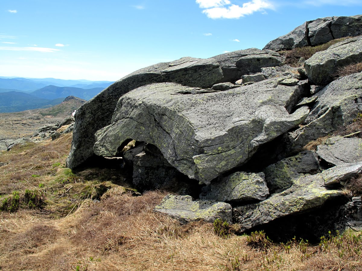
I'd forgotten about this rock formation which sits a few hundred feet above the Tuckerman Ravine headwall and in a unique area of the summit cone that has a number of 'seeps' where water trickles out of the mountain and creates wet habitats for plants like False Hellibore and Indian Poke. The rock ledge is unique as well and formed by the last continental glacier, the Wisconsinan glacial ice sheet. That's Mt. Monroe just behind the lip of the rock ledge.

Another perspective showing the folds in the rock and overlapping by two large rock formations.

This rock formation looks like a coffee cake that was cut neatly into pieces with a knife and is the result of frost mechanics and an example of how rocks on the mountain were "quarried", or split off from the parent rocks, thousands of years ago. Tuckerman Ravine is in the background.

Last week I cross Bigelow Lawn and in this series of photos I'm a bit higher and looking down on the lawn and some of its features that aren't as apparent when you are walking across it. The photo is looking across to Boott Spur with Mt. Kearsarge in the immediate distance.

This shows the same pattern of rock 'graveyards' and lawn modules stretching out from just below the cone and across this nearly level expanse. As I've mentioned before, Goldthwait and others observed that the physical, or morphological, features of this broad area are ancient and part of a major uplifting that took place 500 million years ago.

Looking South across the southwest part of Bigelow Lawn and towards the Oakes Gulf headwall. The Sandwich Range extends across the horizon.

Bigelow Lawn, although less well-defined, continues westerly almost to the headwall of Ammonoosuc Ravine and down to, and around, Mt. Monore where it is terminated by the erosion features of the ravines. Lakes of the Clouds hut is visible as a dot to the right at the base of Mt. Monroe.

The summit cone from the same location the above photos were taken.

At the junction of the Davis Path with the Crawford Path there's a long string of quartz boulders, some of them pretty hefty, that stretches out on a southwest-northeast tangent and that began as an volcanic intrusion of magma a long, long time ago.

The ice on the lake melted back quite a bit in just a few hours.

At the lake outlet.

From the Ammy (Ammonoosuc Ravine Trail). The cloud patterns indicate a change is due in the weather.
 In Poem in October Dylan Thomas wrote "my birthday began with the water birds and the birds of the winged trees flying my name, the water praying and call of seagull and rook, and the knock of sailing boats on the net webbed wall." My birthday (6-11-10) began with the the call of thrushes, finches and warblers in the tall trees arching over the Amonoosuc Ravine Trail and the sound of the river ecstatic in its light-headed descent of the mountain. The day started with a hint of clear skies and sunshine and I wasn't surprised when the clouds came down as far as Gem Pool and a gray-thread rain made soft drumming noises on new leaves and glistening water droplets hung from the balsam branches like tiny ornaments.
 Here was another birthday boy (on the right), with his family, making a ceremonial hike to the summit of Mt. Washington on his 82nd birthday. He's climbed the mountain on several birthdays during the decade of his 70s and he was delighted to be back on the Ammonoosuc Ravine Trail, he said.
 I was soon at the lower end of the area hit by the avalanche in late January. The section of trail hit by the slide has now been cleared of the fallen and tangled trees and the cleared debris lines both sides of the trail for several hundred yards
 including this downed balsam fir with its root ball still intact.
 The impact of the avalanche will be visible for many years to come. An interesting aspect is that some of the larger trees that were bowed over by the avalanche are making a come back. At the same time some of the smaller trees and shrubs that were already buried in snow were passed over by the avalanche and now they, as well, are turning green again with new leaves so there is a 'succession' already taking place. The contrast of the lighter and darker greens up the walls of the ravine show how Spring is progressing up the mountain.
 This is my favorite stretch of the Ammy where it comes up out of the trees and onto the ledges just below the hut. It's finally free of snow.
 It was great to see this character again! His name's Johannes Griesshammer and he's hutmaster at Lakes this summer. He's been working in the huts for several seasons and has a great croo for the coming summer including Arran Dinsdorf who worked at Lakes las tfall. Arran's dad, Mark Dinsdorf, worked in the huts shortly after I did.
 The clouds were down to below 4,000 feet. This is that small plateau between the large Lake and Mt. Monroe photographed two weeks ago covered with Diapensia.
 And these are two 'cushions' of Diapensia photographed two weeks ago with a number of blossoms on each.
 There were still Diapensia blossoms in protected pockets around the lake and up Mt. Monroe but their numbers were far lower than two weeks ago.
 Canadian Mayflower (Miaianthemum canadense) is beginning to blossom.
 So is the Low Blueberry (Vaccinium angustifolium).
 Mt. Avens (Geum peckii) will flower in about two weeks,
 and Bunchberry (Cornus canadensis) in about two to three weeks.
 The tarn near the Crawford Path and Monroe Flats is full again which is a healthy sign. There's been plenty of rain and fog during the past two weeks so the water table is up at least for awhile.
 This is one of the time-lapse cameras that AMC researchers have installed on Monroe Flats to track a few alpine species to pinpoint flowering times as part of a baseline study of variations in the times these plants flower from year to year.
 My purpose on Friday was to photograph a Dwarf Cinquefoil (Potentialla Robbinsiana) in blossom but, alas, they had past the blossoming stage. I'd missed it again this year! But the good news is Caitlin McDonough (a research scientist with the AMC) took this exquisite photo of a Robbinsiana in full bloom on June 3rd or 4th, right at it's 'peak', and is graciously allowing me to publish it. She confided how proud she was of the photo and I would be, too. It's the best photo of a P. Robbinsiana that I've seen.
 Next to Caitlin's photo my efforts from Friday look a bit dreary (like certain friends of mine on New Years Day) but this shows the array of blossoms and how they look at the end of the flowering stage when seeds have developed and are ready to drop. It's is the last bit of the Robbinsiana's reproductive cycle. The plants will continue to photosynthesize energy and grow for through the summer but the big push to produce its showy, yellow flowers and crop of seeds is complete. Most flowering plants, whether it's broccoli or irises, take more than 7-10 days to complete this cycle but the Robbinsiana and other circumpolar plants on Mt. Washington, the Diapensia and Lapland Rosebay, are uniquely adapted to do this in the extreme, early part of the growing season, even earlier than other alpine species. They take advantage of what, for them (configured to arctic conditions) is a tiny window of optimal conditions. Flowering plants growing at much lower elevations are adapted to a more elongated time frame. For instance, I missed coming to Lakes last weekend because I was planting tomatoes and other crops which take a more leisurely path to the flowering stage and they won't develop fruit for another two or three weeks. (Of course, tomatoes are spin offs of old, neo-tropical species that have hybridized so much that they really can't be compared with Robbinsiana or any wild plants.)
 Reindeer Lichen (Cladonia rangiferina). It looks like corral. This is one of the Fructose Lichens and is common in the White Mountains. Lichens are amazing plants. There are 11 species on Mt. Washinton divided into three genera of Lichens: Fructose, Crustose, and Foliose.
 Worm Lichen, (Thamnolia vermicularis) is another Fructose Lichen. These stalks, which grow close to 3 inches long, are actually hollow and quite fragile. It's rare and found only in a few places including Mt. Washington, the Adirondack Mountains in New York, and the Rocky Mountains
 These are actually immature Worm Lichen but they look like a separate species.
 There are several species of Cladonia on Mt. Washingon including this relatively common one, British Soldiers (Cladonia cristatella) which grows in banks of moss and stand out because of the red fruiting bodies at the tip of the plant. Lichens are two plants in one and are made up of a singled cell algae, a green plant that photosynthesizes, and a fungus. The fungus determines the shape of the plant and the algae provides the food.
 Bigelow (or Alpine) Sedge (Carex bigelowii),which is found everywhere on Mt. Washington and just about everywhere on Presidential Range.
 Water droplets on Bog Bilberry (Vaccinium uliginosum).
 Looking up towards the summit from the Ammy and this mystical landscape that sometimes reminds me of Scotland, or Labrador, but in a word is beautiful!
 Hobblebush (or Witch Hobble) (Viburnum alnifolium) near Gem Pool.