 On my way to the Gale River Trail on Friday morning (11-19-10) I was momentarily caught in a "white out" caused by a slow moving snow squall near the north end of Franconia Notch that created a magical world of light feathery snow that fell for 5 during which I felt as though I was caught in a toy globe that you shake and it produces a blizzard. It mantled everything: the highway, cars, and the woods along the road. A freakish part was that one minute I was driving in it and then it was gone, like a dream. Suddenly the sky was blue with sun poking through last remnants of clouds. The intensity of the squall was barely evident just a few miles away.
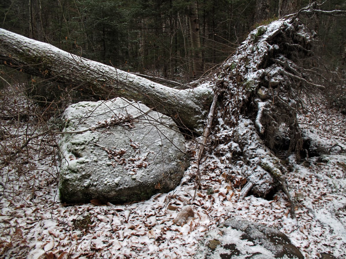 On the trail I was happy to have the dusting of snow as it highlighted details in the landscape and accentuated the late fall colors. At the same time I was hoping there weren't any hunters in the vicinity who might be using the light snowfall to track deer.
 These are glacial erratics sitting just a few yards from the trail that are quite large and practically invisible when leaves are out.
 First Crossing. The Gale was up a few inches, enough to get my feet wet on this and at second crossing. The US Forest Service is getting set to relocate the Gale River Trail completely to the west side of the Gale River eliminating the two crossings which present severe hazards after heavy rains and during the Spring run-off, particularly.
 After the last crossing on the Gale River the trail climbs more steeply up into the steep-sided valley between the Twin Range and the Garfield Ridge and enters this sanctuary that's far enough back from highway and human habitation to fall completely under the forest's spell, the chorus of river, wind and birds, and a wonderful, infectious timelessness.
 It's 3 miles from the trailhead to this tilting boulder that marks the area of the 1954 landslide where my small research site is located. This was my first visit in several months. I've timed it to take measurements before the soil freezes and the snowpack begins its yearly cycle. I picked a perfect day, it turned out, as it was cool and the light, with thin clouds, was flat and perfect for taking photos.
 The next 9-10 photos might seem meaningless. I've included them as time-bound documents of the area where a mass wasting event occurred 66 years ago and where I'm researching soil development and revegetation (plant succession) along the path of the disturbance that was a major landslide. The slide stripped away the vegetation and top soil, leaving the area denuded as a glacier might. The research hopes to define a precise time that it takes a disturbed site to return to an optimal equilibrium or "steady state" (sometimes referred to as "climax"). I'm using two "control" sites. One of them is in Glacier Bay, Alaska, and was researched back in 1966 by a team of scientists under R.P. Golthwait. Their results were published as Soil Development and Ecological Succession In A Deglaciated Area of Muir Inlet, Southeast, Alaska (available through Goldthwait Polar Library, Ohio State University, Columbus Ohio, 43212). Fiorenzo Ugolini was the soil scientist on the team and wrote the chapter on soil development. I'll be collecting data at a second "control" site, a slide that came down during the 1938 hurricane, that's similar in exposure and altitude to the Gale River site. I'll write more about that later.
The above photo is looking up across study plot #1 in the direction from which the land slide descended.
 This is a diagram of the slide looking north. The slide was about 300 yards long from the point where it broke off Garfield Ridge and traveled downslope to the wast bank of the Gale River.
At the river my theory is that the slide made a sharp turn once it got into the river bed and flowed down stream. It's likely that more than half of the debris from the slide landed in the river and some may have made it across. Whatever landed in the river was swept downstream. However, an enormous amount of debris, including boulders, sand, and gravel, spread out on the west side of the river in a football field-sized area to a depth of 6 0r 7 feet. Tree trunks including the roots were caught in the rubble. The Gale River Trail relocated itself as hikers, confronted by the slide track, threaded their way around the boulders and across the vast open area. Hurricane Carol was the weather event connected with the slide. The hurricane surged on a northerly course through New England on August 31, 1954 quickly dumping several inches of rain in the mountains. It's timing, path and force was nearly identical to the historic September 13, 1938 Hurricane that caused dozens of major landslides and destroyed millions of trees in the White Mountains. (Interestingly, Hank Parker, who worked in the huts in the 1940s and who was at the reunion at Madison Springs Hut on August 30th, told me that he remembers a slide track from the 1938 hurricane that was located slightly uphill close to, and parallel to the 1954 slide track from Hurricane Carol.)
 This is a photo taken in November 1968 of the bottom area of the slide looking from south to north. I've written about the research site in several articles (2-14-09, 7-10-09, 9-5-09. 4-24-10) but I'll include this photo again and the one below to save the trouble of looking through the past articles. This photo shows evidence the slide curved into the river bed and headed down stream just the way the avalanche in Ammonoosuc Ravine did last February (2010). It left behind massive boulders that can be seen slightly downstream. The white arrow points to the "tilting boulder" that I sometimes use as a desk and table. Just for reference: this photograph shows the slide 14 years after the mass wasting event occurred. The extent of soil development and re-vegetation can be seen.
 This is a photo of the slide taken five years later in November of 1973, 19 years after the slide, and shows the upslope portion of the slide, with its length and width and the extent of the re-vegetation. The area just behind Ken Olsen is where study plot #1 is located (what's depicted in the photographs from 11-19-10). It's probable that the landslide had a more destructive impact on the forest ecosystem that existed here prior to the hurricane then most other disturbances that can impact a forest ecosystem, even more than fire. The highest cost of the slide to the ecosystem is the nearly total loss of nutrient. Clear cutting, or even an extremely hot wildfire, would leave some nutrient.
In 1973, nineteen years after the slide, the re-vegetation is occurring along the edges of the slide and close to the bed of a small stream that drains the slide. The vegetation is comprised of several shade intolerant species that were present in 1968 including birch, alder, pin cherry, quaking aspen, and balsam fir. It would be impossible to estimate the biomass or basal area of the vegetation from the photo, however we can conclude that the numbers would be low compared to the ecosystem that existed prior to the slide.
 This is a magnified view of the above photo from 1968 showing what the area in Plot #1 looked like 14 years after the landslide. In the upper left hand corner you can see tree stems, limbs and roots stacked in rows along the northern edge of the slide track left there by the slide on August 31, 1954. These represent a small percentage of the trees the slide transported. Most of the debris, including tons of vegetation was carried downstream by the river. On July 10, 1885 when the famous Cherry Mountain slide occurred, Oscar Stanley, a witness, said he felt the ground shake and "when I saw the slide it was full thrity feet high, the front of it rolling over and over as it moved." (Flaccus, 184). The speed of that slide was estimated to be 23 mph. On August 31, 1954, Ben Bowditch, a croo member at Galehead Hut, was packing up the Gale River Trail around 3 pm and said he heard a roar, looked up to see a wall of water descending towards him and had to hold onto a tree for atleast an hour while the water surged around and that was carrying whole trees and boulders from the slide site.
I magnified the photo to better show the extent of soil development and plant succession on the levelest part of the slide. Moss is growing in areas between the boulders and, in additon to moss, plants visible include alder (A. rugosa & A. crispa), balsam fir (Abies balsamea), Red cherry (Prunus pensylvanica), aspen (Populus temuloides), and white birch (Betual papyrifera var. cordifolia). These are shade intolerant species (meaning they thrive in direct sunlight) and are often found growing in disturbed sites such as clear cut and burned over areas.
 This is another photo of plot #1. I'm currently working on determining the biomass and basal area. It's extremely tedious work and it easy to get distracted so I alternate between doing vegetation measurements and soil depths by hand. For the soil measurements I use thin, solid plastic wands (low impact) to measure soil depths at 1 meter intervals on an east-west transect. A random, secondary transect runs perpendicular to the primary transect. I rely on the local weather station in Twin Mountain to track precipitation and mean temperatures that are adjusted for altitude (2785'). I also plot diurnal-nocturnal temperature fluctuations.
Plot #1 has the small stream that drains the slide track running through it on a diagonal course. Vegetation in the plot is dense along the stream bed but less dense in most other areas of the plot. The above photo is of the west side of the stream in an area of the study plot where the vegetation is of median density. The soil depth here is above the mean and is a brown podzol (also referred to as spodosol) with a thin clay horizon. It is a typical boreal forest soil where the climate is cold and damp. It's acidic due to the granitic parent material from which it evolved. The top horizon has a high humus content. The depth of the soil in the area of the photo is 6.5 inches (16.5 mm) a little deeper than the median in this plot due largely to increased vegetation along the stream, a level slope, and dominance of deciduous birch and striped maple trees that provide leaf litter.
 This is another photo of typical terrain in plot #1 for soil measurements showing upended trees and small diameter balsam fir that grow in dense clumps on the steeper slopes.
The Soil development formula is S (soil) = f (time) cl (climate) o (organisms in soil) p (parent material) and r (relief or degree of slope)(Ugolini, 30). In the formula soil, S, is the dependent variable and cl, o, p, and r are the independent variables. In this case the dependent variable, the soil, is being expressed quantitatively as a function of time so the fancy research terminology is "chronofunction" (meaning function of time) (Ugolini, 30). Evaluating the role of time is best where the history of the system is known as here where we have the exact date and time of the primary disturbance.
 This is the northern edge of the slide track near the bottom of the slope that faces east. The vegetation here is not representative of the entire study plot and the soil reflects the difference in the top most horizon which is thinner in this area than the rest of the plot.
 The total leaf litter accumulation is .5 inches for November 2010. It litter appears to be heavily compacted by recent rains but had been heavily compacted earlier by severe winter storms in February 2010. The slope in plot #1 goes from level and then rises steeply upslope. It faces the east so it gets a lot of sun but also gets the brunt of storms like the one last February that came in from the east. Snow depth in mid-winter in this plot reached 88 inches in late February 2010. The snow had a high water content. I hypothesized that spring run off from the heavy snows may have caused "slush flows" on the steep pitch above the study plot that may have taken leaf litter from the forest floor as they descended downslope. The slush flows are part of the hydrological cycle as well as a form of nutrient transport. Landslides are a from of "mass wasting", the downslope movement of soil, rocks, etc. due to gravity. It's also a form of of fluvial denudation, the normal aging process of land forms and collapse towards the gravity "ideal" of the perfectly level plain. To some degree landslides are also part of the large hydrological cycle as water is an intrinsic participant in landslides and involved in transport of nutrients both in and out of ecosystems.
 One of the best sources of info on White Mountains slides that I know of is Edward Flaccus' 1958 Appalachia article White Mountain Landslides (Appalachia December 1958, 175-191) in which he presents exhaustive data on more than 500 slides that occurred in the White Mountains between the late 1700s and 1957. Of the 540 landslides listed, Flaccus was able to date 135 slides to the year, 127 to the month, and 123 to the day. In the case of the 1954 Gale River slide we have the day and the hour the slide occurred.
 Looking east towards the Gale River Trail and the river from the western edge of Study Plot #1.
Flaccus reported that all the slides of which the day's date are known "occurred in connection with heavy rain. Large numbers have occurred during heavy general storms, especially those of the tropical-hurricane type, but there have been a number of occasions on which more localized rains of the summer-thunderstorm kind have been involved. All slides dated at least to the month have occurred in the period of June to November. There are no records of any occurring in the months of snow-melt and spring rains (March to May). Also, all the November slides, with one exception, are attributable to a single storm (November 3-4, 1927) occurring very early in the month. The frequency by months for the period is as follows: June, 15 slides on 5 different days; July, 2 slides on 2 days; August, 63 slides on 4 days; September, 21 slides on 2 days, (total 12 slides on 18 different days)." (180)
One of the earliest of these slides was the most famous of all, the Willey House Slide in Crawford Notch in 1826 in which the entire Willey family and two hired men died during a violent and torrential rain storm that hit the mountains August 27-28 that completely destroyed roads in Pinkham Notch, Littleton and Conway. The Saco River was reported to have risen 24 feet in 7 hours in Conway. The Ammonoosuc River rose 14 feet in the same period of time measured at Fabyan's. The second most famous slide is the Cherry Mountain slide that occurred on July 10, 1885, that trapped Donald Walker and who died of injuries 4 days later on what was to have been his wedding day. A month later, August 13, 1885 the impressive slide on North Tripyramid occurred. Flaccus' article has some impressive photographs from the AMC collection of some of these older slides. The weight of soil and rock transported downslope by all of these slides measures in thousands of tons.
 Flaccus did extensive research on 29 of the slides he had identified (This was his doctoral thesis project for Duke University) noting similarities and differences. He identified three sections in each of the slides: the upper "slide section", the highest area of the slide where the soil is bared to bedrock; the "gully section. Where the slope begins to level out, the slide narrows to a gully form and cuts into the till which usually overlies bedrock at the lower altitude." (181); and the "stream scour section" where the channel is "severely washed and much broadened, all vegetation bordering the former stream bed has been removed, and the trunks of the trees bordering the scour are scarred and barked." The Gale River slide has all of these features just as described.
 Flaccus measured slope characteristics of the 29 slides and averaged the degree of slope at the "slide section" at 32 degrees with a range of 25 to 35 degrees. He observed that slides are not likely on slopes of less than 25 degrees.
He plotted the altitudes for 270 slides and found that the clear majority of slides, 82 percent, had started above 3000' a.s.l. (182). Flaccus reported that their aspects, the compass direction they were facing, was not a significant factor. After degree of slope the most significant factors, are rainfall (although it's not clear how water is involved in triggering slides), the geology at the location of the slide including type of bedrock, and the "fluvial cycle" which involves the erosion and "aging" of landforms. Earthquakes were ruled out as triggering factors but interestingly some observers thought vegetation, moving violently in high winds associated with storm was responsible for triggering some slides including the South Tripyramid slide in 1889. Lightening along with loud thunder was said to have been responsible for the Cherry Mountain slide in 1885. Clearly the degree of slope and occurrence of torrential rains at the time of the slide are the primary factors but then the question remains about why they only occur in certain locations, why not in many of the locations that meet the criteria for slope, bedrock and altitude?
 A brief burst of morning sunlight caught these birches and gave me a some hope that climbing to the summit of South Twin might be a good gamble.
Flaccus added a section on revegetation occurring on the landslides he studied and reported that on the slides upper sections where the bedrock is exposed vegetation will take a long time to recover and at high altitudes pioneer plants my be extremely slow growing. In the lower slide sections he found that the forest will reestablish itself in time and is most rapid on the flatter, deposit areas "which are heterogeneous mixtures of boulders, gravel, sand and organic matter (mostly macerated trees) deposited like moraines."(189). He suggests that slides less than 50 years old show mostly pioneer hardwoods such as the birches in the above photo into which the spruce and fir slowly dominating so that in 150-200 years the slide will not be noticeable to casual observers.
 This is the small brook that drains the landslide and joins the Gale River just downstream from the slide site. Most of the rocks in the photo are granite. The brook is a conduit for nutrients leached out of the slide and transported downstream to other locales. The nutrients include both suspended and heavier particulate organic and inorganic matter, as well as cations and anions (ions) such as carbon, calcium, manganese, potassium, phosphate, etc. plus nitrates and sulfates to name just a few. Most of these come out of the soil, but they also come from the vegetation.
 Looking across a shoulder of North Twin towards the summit of South Twin. I decided to try for South Twin on impulse and the warmth of the sunlight.
 Looking back at North Twin from the Gale River Trail.
 The third and last steep section of the Gale River Trail as it climbs out on Garfield Ridge.
 Balsam seedlings along the exposed upper section of Garfield Ridge. There prolific numbers are a response to disturbances caused by high winds from the northwest that upend a lot of the firs from the north flank of Garfield all the way across the ridge and up the west flank of South Twin.
 The snow helps one appreciate the sheer numbers of new seedlings huddled in these exposed sites that offer mutual shelter from the winds and help stabilize the soil in case of a blowdown.
 Here is a site just below Galehhead Hut that has been disturbed countless times and struggles to achieve a tentative equilibrium on this exposed ridge.
 A Christmas card from all the furry little creatures overwintering at Galehead.
 South Twin socked in. The winds were light at the hut but the upper elevations were getting a little more and I decided to wait it out for a while before climbing higher. To the west there was some patches of blue sky. You reach decisive moments when you know if you go higher it won't change, but it you go back down it will clear up within 30 minutes.
 Galehead Mountain was clear when I first go to the hut.
 I sat around in the shelter of the hut for an hour until I began to really feel the cold
 and the clouds began to descend again.
 Looking down into the Pemi (Pemigewasset Wilderness) from the hut. I thought, with these clouds lifting a bit, I'd gamble a little more and started up South Twin only to have the clouds come down around me while a light snow began to fall at which point I bailed.
 The shallow depth and firmness of the snow on the trail made it perfect for running so I was able to get my body temperature back up quickly.
 and by the time I was down to the walkout part of the Gale River Trail, on the flats, it was clearing (as predicted) and still early in the day.......
 .......but I continued down through these lovely colors.


