Saturday, July 14, 2012

7-14-12 Mt. Washington and Lakes of the Clouds (Additions))

Heading up the Ammy today in early morning sunlight.  I ended up on the Ammonoosuc Ravine Trail (the Ammy) with no real intention to do so. I didn't have any plans for the day. I've wanted to spend more time off the beaten track this summer particularly further away from the huts, but after taking most of June off, and May before that, I felt rusty, and the Ammy called because it didn't require any planning. I didn't have to think at all. I'd been listening to Bob Dylan and Dave Matthews for hours on the drive up and the mood had pretty much been set to get up high. Besides it was too hot to be hiking down in the woods.
Saturday promised to be an idyllic summer day, though a bit on the warm side. There was lots of sun and white clouds and a wind from the northeast to cool things a little. The river's full and pulsing down the ravines and the white throat sparrows are everywhere with their mountain song. A perfect day to head up the the ridge. And, after thinking about it during the first half mile, I was able to dream up some other incentives. One was to try and find the station(s) for Alpine Brook Saxifrage and possibly a station for White Mountain-Saxifrage. The latter is not usually found in the White Mountains, only on Mt. Katahdin, but recently some have been recorded on cliffs in Franconia Notch.
This area next to the trail (the trail is over on the right) was wiped out by flooding during Hurricane Irene and was a maze of broken and torn up trees until recently. The broken and downed trees have been cut up and removed. If you look directly ahead you can see that the extent of the flood damage extends up the river bed for more than a 100 yards parallel to the trail.
Some of us just don't like the heat.
Every time this family stops to rest the girl takes out her cell phone and checks her messages.
Cool, sweet Gem Pool.
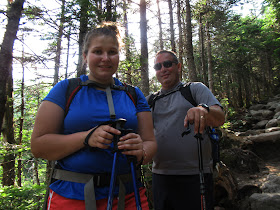
This guy was great. He spent the night at Lakes of the Clouds Hut and was one of the first to get out in the morning to take advantage of cool temperatures and to avoid the crowd. He said he was doing pretty well "for an old man." I commented that he looked like he was my age and he said "no, I'm 65. You look like you're 49 or 50." You gotta love him!
This spirited and hilarious duo, both 15, were hamming it up for the camera. They're heading for the summit and celebrating having reached the top of the Ammonoosuc Ravine head wall which is the more difficult part of the climb..
Another pair coming down from the hut. Most of the people I talked to today were hiking Mt. Washington for the first time. That's kind of astounding.
A truly enchanted part of the trail just below tree line.
The hut was packed with large groups of folks heading up to the summit of Mt. Washington. A few were hiking Mt. Monroe (in the back ground), but Mt. Washington was the day's goal for most. Hikers flooded in an out of the hut and Molly Muller, Assistant Hut Master, was handing out bowls of soup so fast that one had to marvel at how fast someone was cooking it plus her dexterity at not spilling any. I thought about taking a croo photo but with the surrounding chaos it looked impossible to get the entire croo together in one place even for a minute.
The water level of the large lake is several inches low but still within a range of normal for this period of the summer.

The east end of the larger lake.  I'll SCUBA dive here in a few weeks to complete a total plant count in order to compare data with plant counts completed back in 1965. The average depth of this part of the lake is roughly 7 feet. I've tried to do the counts by snorkeling but, as you can imagine, it means only staying down for a few minutes then flitting up to the surface and back down to the plants repeatedly which is a nuisance The aquatic plants referred to are Short-spined Quillwort (Isostes muricata) as identified by Slim Harris 60 years ago, and they grow exclusively at this deeper, eastern end of the lake. They're native to Greenland and the Arctic but have a southern range to Pennsylvania, Colorado and northern California. It would be interesting to date the specimens in Lakes of the Clouds.

The western end of the lake with the outlet on the right. The depth varies towards the outlet but it's generally 3-4 feet deep. There are large rocks scattered across the bottom here like paving stones.
The small lake which, as you can see, is quite shallow. The water level was a few inches low and because of the ratio of surface area to depth and unseasonal warm temperatures loss may be due to increased evaporation.  The high temperature on the summit today was 67 degrees (F) and the temperature near the hut was probably 10 degrees warmer. The sun was stunningly hot as well.
Boott's Rattlesnake-root. It was difficult to photograph flowers today because of the wind. The foliage in the photo belong to Geum peckii, or Mt. Avens. The Boott's Rattlesnake-root has the white flowers.
Trying to get an in-focus photo of these Mt. Avens blossoms on their thin stalks as they bobbed and weaved in the wind was irksome.
I sorted it out by taking a photo of an entire clump of Mt. Avens growing in a tuft of Deer's Hair, (Scirpus cespitosus), which is a common sedge in the alpine zone.
Bunchberry (Cornus canadensis), member of the Dogwood family, were more cooperative. They are ubiquitous along the trail from the Cog Base Station to the hut. It's amazing how successful they are in this setting and all the way up to the alpine zone. Their methods of reproduction/ propagation are highly efficient. The seed in contained in a berry with a waxy coating that is, on the one hand, agreeable to the appetites of many critters who scatter the seeds. With their waxy coat, they also float superbly and are easily transported by floods or, even, tiny rills of rain water.
This is Mountain Sandwort (Arenaria groenlandica) and often confused with Diapensia and a few other flowers growing within the same range. Diapensia blooms much earlier on the Presidential Ridge than Mountain Sandwort which doesn't blossom until after Diapensia is finished flowering. Mountain Sandwort grows in these tufts like the one in the photo which also resemble Diapensia. Slim Harris wrote in Mountain Flowers of New England (AMC, Boston, 1966), "it's attractive white blossoms are everywhere, and the plants seem to be particularly numerous in or close to trails so that in a thick fog the white streaks made by the masses of blossoms are sometimes easier to follow than the cairns."
Mountain Sandwort is particularly showy in early to mid-July and extends over wide areas often right next to the trails. This configuration is on a part of the old Crawford Path near the junction of the West Side Trail.

Flowers not photographed that were present today include gold thread, or Coptis trifolia, alpine goldenrod, dandelions, and "pearly everlasting".
Another great character out enjoying a lovely summer day.
Summer and winter this part of the Crawford Path, as it begins its ascent of the steep summit cone of Mt. Washington offers some of the finest views in the White Mountains.
Ben Kimme, naturalist at Lakes of the Clouds, packs down part of Saturday's requisiton...
followed by Jenna Maddock, left, and Galen Muscat, in blue. I was pleased that the Lakes croo has a number of rookies, or new, first year employees, with no previous experience. Talking to them reminded me of my first summer in the huts and how exciting and rewarding it was. There was enormous responsibility but the work was pure adventure; electrifying (I don't mean getting hit by lightening).
I opted not to hike all the way to the summit (per usual) and turned right just below the old horse corral and headed down the southeast flank of the summit cone and then out across the west side of Bigelow Lawn. It was hot, like a desert, and deserted as well.  There wasn't another soul on that whole, solemn plain. Interesting that the Crawford Path had bumper to bumper hikers but there were none to be found on other parts of the mountain. An exception would be the Tuckerman Ravine Trail corridor to the summit on the east side of the mountain which was probably as busy as the Crawford Path today. Is it possible that the summit is the only worthwhile destination?
A rock stripe formed by frost action over thousands of years. Geologist Richard Goldthwait used to bring his interns here to Bigelow Lawn more than 60 years ago to study as well as measure and map these rock patterns. I like to check them on occasion to see if there are any measurable changes.  
Before heading down I checked out several stations for a dozen plants that I visually keep track of  year to year. I keep them sorted out with a map.  I missed the early summer last year but those plants that I've identified on the map are doing well.  There was some concern earlier in the spring about stress over the summer due to decreases in winter precipitation which is important to these alpine plants but the lawns are green and the flowers, though past flowering, do not appear to be stressed.
The forest on the head wall of Ammonoosuc Ravine.
An anxious group. They'd set out to reach the hut but because of the heat and the steep trail they were having second thoughts about continuing. It was their first hike in the White Mountains.
Jumping into Gem Pool.
This was a first for me to find a large group of people swimming in Gem Pool. I have jumped in and jumped right back out again to cool off but they were fully enjoying the cold water.

1 comment:

  1. I like your people photos and comments - did not wonder about it at all

    ReplyDelete