Tuesday, October 16, 2012

10-16-12 Notes

Franconia Ridge, Mt. Carrigain, and Sandwich Range from Mt. Moosilauke
I wanted to mention that I've  received some wonderful, thoughtful letters from many readers in the past months that I really appreciate. I'm glad you're enjoying the articles and the photos and I have to say I'm flattered by what's been written.

One email I received the other day regarding my hike up Moosilauke last Saturday (10-13-12) was from Cory Ahonen who wrote, "Alex--As an avid reader and appreciator of your blog, I would have stopped and chatted for awhile en route to the summit of Moosilauke last Saturday had I known it was you I passed (I had the fluffy white American Eskimo dog bounding towards snow). I admit, given the chill in the air, your shorts did appear a bit 'crazy'! That said, it felt absolutely brilliant to be chilled to the bone at the top admiring the views. Thanks for sharing your passion for the New England forests. I've learned a lot." (Cory and his dog flew past me on the lower part of the Gorge Brook trail on Saturday. I almost caught up with them just below the summit.) Thanks for the note, Cory. I, too, felt the brilliance of being buffeted by the wind, chilled to the bone, and exhilarated by the astonishing views from the summit as essential pieces of my experience of the hike on Saturday.

There's a great line in John Steinbeck's Travels With Charley (speaking of traveling with dogs) where Steinbeck contemplates the life of a farmer who retired and migrated from northern Maine to Florida and wondering how the Maine farmer will fare in all the Florida heat he asks, "for what is warmth without cold to give it sweetness?"

And another email which came in the wake of the bear story at the end of the Passaconway article (9-29-12) from none other than Slim Harris' granddaughter, Sara. She wrote, "Looked like an awesome day on the mountain, Alex. Beautiful trail, beautiful forest, beautiful day. I had to laugh at your bear story. It sounded like my grandmother, Calista Harris, who also met and chatted with bears over the years. Her funniest was one time she had a bear outside their camp, which she'd watched for quite a while, but finally could no longer see from the windows. She started to open the big wood door to see if he was lumbering down into the woods. The door hit something and stopped, which she realized was the bear sitting on the granite boulder that was the front door step. So she said, "I beg your pardon", and quickly shut the door.
Calista (aka Cal) Harris (L.) with a friend on the Zealand Road 1984
Jack Boothman who used to live in the yellow farm house at Appalachia, at the bottom of the Valley Way trail that leads to Mt. Madison and Mt. Adams, in Randolph, NH, had all kinds of trouble with bears on his farm. They used to raise hell with some of his out building and one shed in particular. They were always trying to break into it so he took some #10 spikes (very long nails) and drove them through the door from the inside out thinking they'd keep the bears from breaking in. One day he was out by the shed and saw all these bear tracks in the snow coming and going around the shed. He looked at the spikes in the door and they were covered with bear hair. Evidently, by trying to deter the bears, he'd actually created something they could make good use of: a bear back scratcher. The funniest part was the number of bears who'd been coming to use it gave Jack the idea that they were mentioning it to other bears in passing.

One last bit, a few months ago the blog had gotten up to about 100,000 "visitors" over 5 years but it has suddenly become somewhat popular and the number of visitors is increasing by leaps and bounds, to more than 100 per day. It's an exciting development but one I did not expect and, at any rate, I'm too modest to make much out of it. I would like to welcome new comers, though, and remind readers that comments, questions, and requests are always welcome!

Sunday, October 14, 2012

10-13-12 Mt. Moosilauke via Gorge Brook Trail

This couple's clothing to the cool temperatures in the mountains on Saturday morning. The photo was taken just behind the Moosilauke Ravine Lodge in Benton, NH, below Mt. Moosilauke which was my destination. Of course, I was in my new lime green Patagonia shorts. The temperature at the Ravine Lodge at 8 am was 25 degrees (F). On Mt. Washington it was 9 degrees (F) with a windchill of -19 degrees (F). The wind at the Mt.Washington Observatory was around 50 mph and they measured 2.4 inches of new snow. Moosilauke summit conditions would be less severe but still pretty cold and windy with a morning windchill around 0 degrees (F).
The old foot bridge over Gorge Brook at the bottom of the trail. There's a relatively new, sturdy foot bridge that crosses Baker River (first crossing) below the Ravine Lodge and it takes the stress out of crossing the river in high water. I'd been thinking of a completely different adventure on Saturday. I was going to bushwhack up Coolidge Mountain which is at the southern end of the Franconia Ridge just above the town of Lincoln in order to scout a line for my Pemi Traverse. When I saw the snow on the high peaks from the interstate I decided to go for Moosilauke. It was close by and  it won't be long before the gate is closed and the mountain less accessible. And it was a gorgeous mountain day, perfect for getting up high. Moosilauke is just under 5,000 feet at 4,802 feet. Another reason to climb Moosilauke was that I haven't climbed it for several years. The last time was with Liz, my daughter, so hiking it today would be like spending time with her, in a way, even though she's in Tahoe, California.
The first kiss of morning sunlight on the balsams next to the trail. I went up Gorge Brook. It used to be a gutsy trail that went pretty much in a bee-line from the Lodge to the summit. They rerouted it  a few years ago and added a mile of switchbacks to soften the steepness of the ascent.
Baker River comes down out of Jobildunc Ravine on Mt. Moosilauke and Gorge Brook dumps into it just downstream from Ravine Lodge. On special occasions as a kid I got to fly fish Baker River, and nearby Lost River, which also starts high up on Moosilauke, for brook trout (we referred to them as "brookies".) that both rivers were famous for.
Two hikers on Gorge Brook heading for the summit. They're amused by my clothing, or the lack of it.  Often during my hike I was asked if I was crazy to be wearing shorts which, for those who know me know that shorts are my standard hiking garb except above timberline when there's a deep chill and/or windchill below 10 degrees (F).

There had been a light dusting of snow in higher elevations on Friday that turned the lower portions of the trail into a kind of Hansel and Gretel motif and was probably making folks think about Christmas. It was pretty and nice to see. Hopefully we will have real snow this winter.
 
The portions of the trail that were re-routed several years ago to fix problems with the old Gorge Brook Trail are well cared for. Erosion is minor.  The goal was to make a safe trail for an ever growing population of hikers, a veritable flood, that grows annually. The 4000 Footer Club program, alone, incrementally, year by year, increases hiker numbers. With lighter gear, etc. the 4000 Footer approach is compelling and has added incentives including those who use the 4000 Footers as a means of getting and staying in shape and staying healthy, incentive that are incredibly in vogue right now and a phenomenon we should applaud. By themselves, not specifically because they are in the 4000 foot category, Mts. Moosilauke, Washington, Adams, the Lafayette-Little Haystack loop, and Carrigain are already established, attractive, and accessible destinations for most hikers. The have panache as being some of the more alpine, rugged, highest, etc. My point is only that that higher numbers of hikers means much higher densities of hikers on some hiking trails and those trails will require more intense scrutiny and upkeep as well as philosophical considerations because it all leads to greater expenses.
The forest on the mid-section of the Gorge Brook Trail looks young as if the area was cut over 20-30 years ago.There are some good articles on the logging history of Moosilauke in Appalachia the AMC's excellent journal.

This is added 10-28: Anyone interested in the Forest History of Mount Moosilauke can find an article by that title, written by J. Willcox Brown, in the June (Part I) and December (Part II), 1958, Appalachia. The articles are incredibly well written. Part II starts on pg. 221 of the December issue. Photo copies are available through the AMC Library, 5 Joy Street, Boston, MA 02108, or 617-523-0636.

 A corridor of balsam firs (Abies balsamea) leads to the summit slopes of Mt. Moosilauke that unlike most of the summits in the White Mountains resembles a broad pasture and, seen from a distance, looks nearly flat, just slightly domed shaped. Speculations over the decades by geologists have it that Moosilauke was once as high, or higher than Mt. Blanc, or the highest peaks in the Rocky Mountains, or between 14,000 and (one speculation) 18,000 feet above sea level. The summit's broad, low angled dome is not the basis for this speculation. The Wisconsinan glacial ice sheet is primarily responsible for the present shape of the White Mountains generally in addition to post-glacial weathering and erosion during the past 10,000 to 11,000 years. As to the balsams they are twice the height they were 40 years ago, in the early 1970s, so they are growing at a relatively slow pace for balsams.
At the end of the corridor is this which shows the dome.
This is what you reasonably call a "bank" of balsams. These were organized into this phalanx by a number of factors wind and available water being the predominant ones. I have slides from 1970 of this particular group of balsams and some closer to the summit that I have to process in Photoshop and will add them to the article later. The comparison is interesting.
Looking pretty much due south towards Lake Winnipesauki (or Winnipesaukee. It depends on which side of the lake your were born.) You can see Mt. Gunstock in the distance on the right of the lake and the Ossipee Mountains on the left side.
The summit in sight.
 
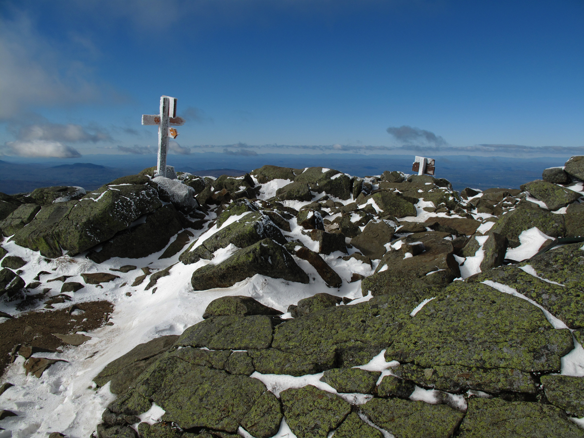
The summit: 4,802 asl. There was a steady, cold wind, around 30 mph, with clouds scudding right over my head.
Looking northeast at the Franconia Ridge with Mt. Lafayette the higher peak to the left. I sat and waited for the clouds to lift to get a better photo of the entire ridge but the clouds were consistently low for the better part of an hour. They were waiting for the sun to heat up the air in the valley. Here the clouds were right over my head.
A telephoto of the north half of the Franconia Ridge with Lafayette and Lincoln plainly visible.
This is a telephoto of the lower, southern end of Franconia Ridge with the iconic Mt. Osseo, or Whaleback, right in the center of the photo and down one ridge. It looks like a porpoise, or whale fin with the animal swimming towards the left.  This is one route I'd planned to bushwhack up today but changed my plans. I'm glad I had the chance to reconnoiter from Moosilauke because the maps aren't as good as looking at it. Mt. Coolidge in low in the center of the photo. It looks like a long haul across Coolidge's west ridge and up to the summit of Mt. Flume, on the left side of the photo (with the slides). From Flume I planned to descend rapidly into a hardwood filled ravine that runs down to Lincoln Brook. It's getting pretty late in the season to consider the traverse at any rate. Unless I did it with a full moon next month and had decent weather for hiking at night I'll probably postpone it until next season. In the photo that's Carrigain on the right and Mt. Washington is a small white patch on the far left in the background.
A wider view towards the east with Mt. Carrigain, again, close to the center in the middle background. Mt. Kearsarge, my old friend, is just to the right of Carrigain in the background, then Osceola, Tripyramid, Tecumseh, and Sandwich Dome. You can just make out the summit of Passaconway next to Osceola on the left.
The ridge to the north towards the Beaver Brook Trail and Kinsman Notch. I could reach up and touch the cloud as it passed overhead!

 
Looking back at the summit from the north end of the summit plateau so you can see it in profile from the north with the gentle curve of the dome. It's almost flat.
Heading back to the 45 minutes later and the summit is getting populated with the first day hikers.
 
  A crowd was beginning to form, an indication that there were lots of people on the trail heading up.
The couple I photographed at the Ravine Lodge, plus a bevy of other hikers trying to stay warm in the harsh wind.

 
It was dog heaven. In all, I saw 11 dogs on or near the summit. Most were golden retrievers.

 
A couple from Bartlett, NH. who are doing the 4,000 footers. I descended against a staunch tide of upwardly mobile hikers, nearly a continuous line. I lost count. The diversity was wonderful in every way you can make note of it. There were quite a few folks my age, but a lot of college-age hikers, too. There were people from France, England, Germany, Calabria in Italy, Canada, Finland, and New Hampshire. It was a lovely day. Everyone had questions. On the summit I was called on often to name all the mountains in a 360 degree circle starting with Camels Hump in Vermont and ending with Sugarbush just to the left of it. I named the peaks clockwise.

Back near the bottom it a warm, lovely fall day.


The Venerable Ravine Lodge which has been owned and operated by Dartmouth College for years.
The view of Moosilauke from the Ravine Lodge. It's calling out to you.

Tuesday, October 2, 2012

9-29-12 Mt. Passaconway & Sandwich Range Wilderness (in progress)

Changing color, these Lady ferns (Atherium filix-femina) at the edge of the trail head parking lot for the Mt. Wonalancet Range Trail, are a formal announcement fall has arrived.
This past weekend (9-29-12) I was trying to catch up with September which has flown by with astounding speed. It's a coveted time for hiking with its fine wine-like mountain days but I needed to spend most of the weekends trying to out run an avalanche of over due paper work at my agency; reams and reams of useless stuff that I had pushed aside for a year, or more, and it had caught up to my very heels. That was all forgotten, though, as I headed north on Friday on my way to hike with my good friend Sheldon Perry. I stopped briefly in North Conway Friday night and joined a priceless gathering of my former elementary school classmates in a wonderful celebration of a successful fund raising campaign, The Damon O'Neal Scholarship Fund, that was started three years ago with hopes of assisting potential US Olympic skiers from Kennett High School.  North Conway, the entire Eastern Slopes region, over the years has produced its share of Olympic skiers most recently Leanne Smith ( right) who is a member of the current USSA A Team and routinely finishes right behind Mancuso and Vonn. The Damon O'Neal Scholarship now has enough money in it, according to Rolly O'Neal, to last until 2042!


It was raining buckets Saturday morning so Sheldon and I, for our hike, decided to stay low and close to his abode in Tamworth, NH. We headed for Mt. Passaconway and decided to climb it by first ascending Mt. Wonalancet via the Wonalancet Range Trail, continue on to Mt. Hubbard, and, finally head up Passaconway via the Walden Trail. Even with the weather it was a beautiful day to be in the woods. The fine, gray-threaded rain and mist brought out the rich, evocative smells of approaching Fall. I love hiking in the rain as much as in any other weather just for the sensual spell it casts over the woods.

The photo above shows part of the Wonalancet Intervale that's part of Tamworth and where we started our hike. Each summer, as a scrawny kid, I spent a few weeks here with cousins when Wonalancet was idyllic in its secluded beauty and remoteness from the rest of the world, nestled at the foot of Mt. Whiteface and Mt. Passaconway. For years (prior to European contact) it was the site of the summer encampment of the Pennacook band of Abenaki-related people. The mountains is named for their famous chief, Passaconway, who was an extraordinary and brilliant man. His son's name was Wonalancet.
The Sandwich Range Wilderness was created in 1984. It's an extremely important portion of the White Mountain federal lands that resembles a jig-saw puzzle with several other wilderness areas as well as the White Mountain National Forest (WMNF) as snug fitting pieces of the whole. All of it is maintained by the US Forest Service (USFS). The Sandwich Range Wilderness is important for several reasons. The primary one being that it protects the "southern flank" of forest lands which are far more vulnerable to commercial development from the south (along the Interstate highways). It also protects a region of great beauty that is home to many albeit lower peaks, but arguably some of the loveliest in New England like Chocorua, Passaconway and Sandwich Dome.
I used Sheldon here for scale in what resembles a rock "river" coming from the upper southeast flank of Mt. Wonalancet. It's a bit of a puzzle to figure out whether they're glacial erratics,  blocks that have been quarried by frost action on cliffs higher up on the mountain, or some of both. Sheldon voted for erratics and I for frost quarried blocks (felsenmmer) but it could perfectly well be both.

At any rate you can get idea of the extent of the mass of all these rocks as they spread across and up and down the slope.

These two boulders look like they have tumbled here from above.
This boulder looks similar to a cartoon character with its exaggerated mouth. A probable question to ask is how did the top of the boulder, after it was sheared in half by frost action, lose some of its mass so that the two halves don't fit exactly together.
Comparing both photos shows that the two halves are congruent, but the fit is uneven. That's quiz #1. Why?
The Wonalancet Range Trail threads through the rocks and finds level terrain on a bench that runs parallel to the contour lines through the wet woods that were suffused with the bright green reflecting from the overhead beech leaves.


Soon the trail turns left right into the mountain and begins to climb steeply up past this huge tilting chunk of granite that's got a roof of common polypody ferns (Polypodium vulgare L.). It's also decked with sphagnum moss, rock tripe (Umbilicaria hyperborea Ach after Slim Harris), creeping snowberry (Gaultheria hispidula L.) and probably numerous other plants.
Sheldon on the steeps. It was much steeper than the photo actually shows.
Roots of the red spruce (Picea rubra) searching for a good "foot hold" on the bare granite. This is base level of the "conferous caps" (confierous vegetaion as in balsam, spruce, hemlock etc.) we find on the upper summit regions of mountains all over the US. The conferous are better adapted to the poor, thin soils in these niches than are most deciduous trees with the exception of white and yellow birch, cherry, mountain maple and striped maple.
Steepest part of the headwall with an intriguing cave, or overhang, between two house-sized boulders.
At the top of the steep climbing we found this lovely path striking out in the rain along the nearly level ridge which it does for 2.2 miles until it's junction with the Walden Trail.

As soon as we reached the ridge we were greeted by an assortment of glacial erratics like this one. Many of the erratics we passed Saturday were huge. They were right there on top of the ridge where they couldn't have gotten there any other way but by  glacier express. There was one as big as a small house off of the Dicey Mill Trail.
 It's lovely and I'm going to have to key it out because I don't know the name. I was going to say it's an Agaric, but now I'm not sure. Mushrooms are kind of fun to key out.
The trail was enchanting particularly in the rain and mist. It beckeoned us along with its twists and turns. I'll spare you words for a moment so you can just look at the photos and imagine yourself relaxed and enjoying the trail.

 A giant toad?

Wild Sarsaparilla (Aralia nudicaulis L.) A ginseng family member.
There were many small "caps" or summits in the 2 mile stretch with limited views to the south and west.
This is looking southeast from Mt. Hubbard down towards the Intervale (far left) where we left the car. On a clear day the view would be smashing.

This small pool of water in a "sink" in this ledge reminded me of our early methods of "hydrating" in the days before fancy plastic water bottles and resevoirs that fit in back packs. In the history of the "hut traverse", for instance, these little pools of collected rain water were often used as the only source of water between two huts. When I was trail running I used to drink from these rather happily. There were often times when you competed with a variety of small swimming insects for the precious water.
The series of photos ahead are mainly of the trail and offer a first hand look at the terrain and vegetation on the ridge. I'm including a number of them if only because I've long been intrigued by the concept of "wilderness" and how we, in the 21st Century, conceive of it. It has become a fleeting entity in my life time. As I walked along this ridge in this wilderness area set aside 30 years ago, I wondered what it would be like here on the ridge in 100 or 200 years from now and what kind of legacy it leaves for coming generations.
More large boulders among the red spruces. The spruce outnumbered the balsam firs on the ridge which is somewhat of a rarity in the White Mountains that seem to be overpopulated with the latter. The next photos represent a about a mile-long section of the ridge.


Occasionally there were small descents when it was satisfying to run for a ways.

A red spruce of grand proportions.
Hobblebush (Vibernum alnifolia).

What remains of a specimen red spruce about 24 inches in diameter that fell ages ago. Remember that when J.E. Henry began logging the Pemi he only took spruce that were 16 inches in diameter, or larger, at first. That's now pretty much the largest sized red spruce you'll find here now.
This is getting close to the summit of Passaconway and to get here the Walden Trail climbed magnificently up a very steep section, a rock climb or "scramble", from a saddle between Mts. Hubbard and Passaconway. It was so rugged and engaging that I forgot to stop and take photos.
Just below the Passaconway summit amid some older red spruce that have weathered many storms.
We bumped into these two friends of Sheldon's who were doing the loop clockwise.
A perfect place for a leisurely lunch next to Dicey Brook on our way back down. We sidestepped the very summit of Passaconway because we were wet and getting cold and because the summit was in the clouds.
At a lower elevation the woods were again suffused with this wonderful green light.
Quiz #2: what made these two perfectly parallel grooves in this large boulder?
The natural destroyers of wood in the forest, various kinds of fungi enjoying a meal
and with a lot of work to do.
Between the summits of Mt. Whiteface and Mt. Passaconway there is an interesting "bowl", or ravine, that has the shape of a glacial cirque. There is some evidence that it may have been carved by a small, local alpine glacier during the same period that the alpine glaciers on the northern Presidential peaks including Mt. Washington. It's an intriguing part of the Sandwich Range Wilderness and has been set aside for research. Near the bottom of this "cirque" and close to the Dicey Mill Trail Sheldon and I found some large maples and large yellow birch trees similar in size to trees I've measured on the north flank of Mt. Adams north of Mt. Washington. They are stately "giants" that rose high above us into the mist.
Sheldon offers a comparison in size to this yellow birch. He looks a bit shy. Sheldon is quite a character and has lived in the north country for many years. A skier of renown he was on a few national ski teams in his Dartmouth College years and eventually turned pro. As I've reported earlier he, so far, is the Course Setter for the annual Inferno ski race on Mt. Washington. He is also a master crafts person, a cabinet maker by trade, and he makes beautiful things.
There were many large boles growing like these over a wide area like these and the ones in the photo below.
On a cold April morning in 1965 I hiked through here on the Dicey Mill Trail heading up to retrieve water samples from high on Dicey Brook to take back to Dartmouth for a research project. It was a cold, cloudy morning and I was moving quickly to stay warm. I was just passing a tree next to the trail (like one of these) when I was struck by falling bits of bark coming down from the tree and heard a scratching-scraping noise. I jumped aside and a black bear, a small female, fell to the ground with a "thud" only eight feet away from me. She looked a bit dazed. I backed away slowly and, with my usual precaution, began talking to her in a calm voice one might use to talk to their dentist, small talk like: "hey, how are ya doing? What you been up to? I'm hiking up Passaconway here. It's kinda chilly this morning, don't you think." She stood up and looked at me quizzically. I kept backing slowly up the trail until I was 15 feet away from here. Suddenly she bent foward and with her two forepaws grabbed a big wad of dry leaves and with a rapid motion threw them up in the air so they showered down around her and she half barked-half-growled a loud "wuff".  I watched her for a second and she didn't make another move. I bent down and gathered a big wad of leaves and threw them up in the air and imitated her "wuff". We looked at each other. "I've got to get going. I'm going to go now and head up the trail for a ways and you're welcome to come along if you'd like," I said. I turned and started hiking again. I got a 100 feet up the trail and looked back. She was following me on the trail. For the next hour she followed me at a distance of 40-50 feet until I got up to the snow line and the going got a little harder. She was slowing down with all the post-holing we were both doing. Then I looked and she was gone. Later, I came down from Mt. Whiteface, after doing the loop from Passaconway. The morning had cleared and the sun was out as I came down some ledges. She was sitting near the trail on her rump gazing up at the sun. I said, "Hi, bruin, what-cha-doin?" Without moving any other part of her body she tilted her head by rotating her neck a little and she looked at me briefly before straightening up her neck and went back to gazing at the sun on a fine, early afternoon in Spring.