

When I pulled in at 8:30 Saturday morning the parking lot was half full and mostly with alpine skiers heading for the various ravines made most accessbile by the Base Station Road and parking lot. The consensus seemed to be that Oakes Gulf was the best skiing left on Mt. Washington but others were heading for Burt Ravine, and Ammonoosuc Ravine.

There were a few familiar faces in the lot. It's not difficult to notice that there are a lot of "regulars" in the Spring Skiing/Alpine Touring (AT) group as well as a handful of new comers. It's popularity today along with the accessibility it provides to all parts of the mountains translates into a separate, new, and challenging "use" of the mountains. AT skiers certainly enjoy a longer ski season then lift assisted skiing, and, generally, more remote and challenging terrain.

One thing is certain. It keeps you in shape.

As I've watched snowboarding and AT skiing grow over the past 20 years I've noticed that the median age of participants is lower than the population that typically uses developed ski resorts with developed trails, terrain, lifts, etc. and that the number of females participating in back country is growing. In the 2012-1013 season ski resorts around the country reported a decrease in the number of snowboarders. No numbers are kept for back country users but in the last two years the ratio of snowboarders to AT skiers is about 1 to 4 at least in the remote ravines (not Tuckerman) of the Presidentals.

Leaving those thoughts behind, my attention turned to the "Ammy", or Ammonoosuc Ravine Trail, or "ART" as its affectionately referred to. This would be my first trip up it in 2013 and I was deliriously happy to be hiking it again. Charles Blood, the AMC Councillor of Trails nearly 100 years ago, along with Nat Goodrich, standardized the Ammonoosuc Trail over three days in September 1916 (even though the ravine had been used as a means to get off the ridge quickly in bad weather for nearly 200 years) and he commented that of all the trails he had constructed in the White Mountains in his career, and its an impressive number of trails, he was most proud to have worked on the Ammonoosuc Ravine Trail because of its sheer beauty. It is a lovely trail.

As I've probably repeated endless times, the Ammy is a meditation.

Its timeless, really, the patterns of sunlight and shadow. The trail on Saturday still had at least 3 feet of snow on it and skiers were using it for skiing off the mountain at the end of the day.

And there's the Ammonoosuc River leaping and cascading next to the trail most of the way to Lakes of the Clouds enhancing the beauty of the trail. There is still some debris from the 2010 avalanche and from Hurricane Irene up and down the river.

Avalanche damage from the massive slide in late January 2010.


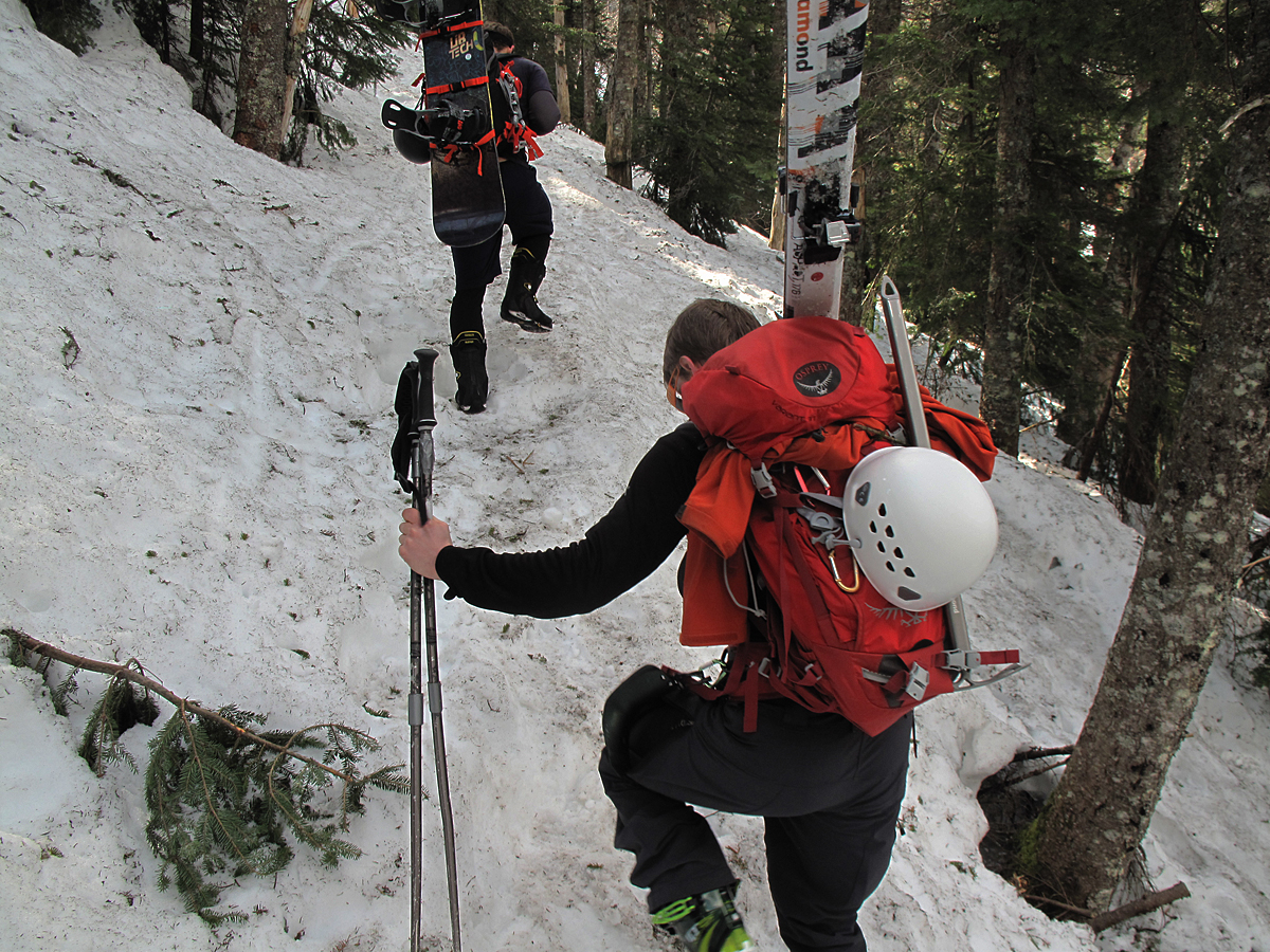
I caught up with these two guys on their way to Oakes Gulf via Lakes of the Clouds; one was on AT skis and the other was packing his snowboard. AT skis hold their own on all terrain and are used for ascents as well as the rapid descent. On Saturday, though, I saw a lot of skiers packing their skis, or "boards", as we referred to them back in ancient times.
After the first 1 1/2 mile, or so, the headwall of the ravine is reached and certainly felt as for a half mile it is astonishingly steep and with frozen snow under foot, a bit sketchy.

The top of the headwall where the trail traverses to the right and back to the river...

......and first crossing....

........and stop and admire this view to the northwest. You can see what I mean by the purples and russet colors. In the middle distance is the Dartmouth Range with Mt. Deception, Mt. Dartmouth and Mt. Mitten L to R. Just behind that ridge is the top of Cherry Mountain, aka Mt. Martha (an older name of Cherry Mountain.) There's a "nub" at the northeast end of the Cherry Mt./Mt, Martha ridge called Owl's Head, which is one of two Owl's Heads in close proximity to each other and which cause no end of confusion. The Owl's Head that's part of Mt. Martha is also referred to as the Jefferson Owl's Head. I did a blog article on a summer hike up the Jefferson Owl's Head back around 8-24-12 with photos and descriptions. It's a great hike.

It's only a hop, skip and a jump to tree line from where trail crosses the Ammonoosuc and where the views become even more spectacular. This is approximately the 2 mile mark in the climb to the hut. That's the summit of Mt. Washington in the back ground. As the day began to warm above freezing everywhere you stood on the snow pack you could hear water running, melt water, underneath the snow and heading down hill.

The view to the northwest improved with elevation gain. This is just below 5,000 feet in altitude.

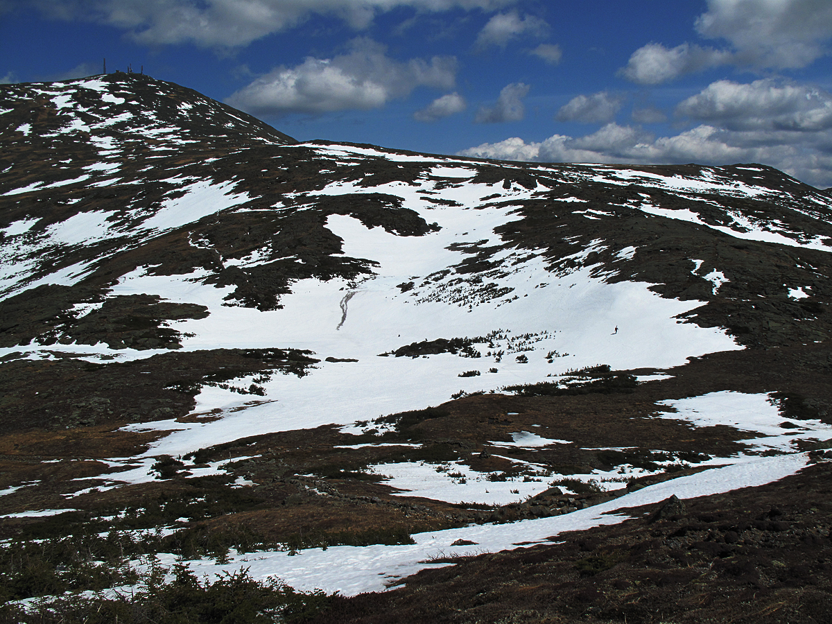
A beautiful day! If you look carefully you will see tiny specks of skiers on the snow fields.

This is packing your "boards".

Lakes of the Clouds Hut with the summit of Monroe to the right in background.

Approaching Lakes from below I was mesmerized by this ice formation next to the hut. It was an ice dam, but I'd never seen one quite like it. It was huge for one thing, and for another, it looked kind of ominous. What if the temperature hit a critical degree and the whole thing let go and some poor soul was just below it?

This is what I found behind the ice dam, a third lake of a temporary nature, or, I guess, a seasonal lake. It was huge--about half the size of a football field and you can see how deep it is by where it reaches halfway up the windows. It's holding a huge amount of water.

It looks like Lakes is sinking!

Decision time. The camaraderie between back country skiers is reminiscent of the early days in Tuckerman Ravine. They're independent but quick to form a spontaneous and loosely knit group, as the group here. Most of them were heading for Oakes Gulf anyway, but a group increases safety for all as well as companionship. Back country skiers are responsible for their own rescue, or Self Rescue, if they're hurt, so the group adds some insurance. One caveat has been the terrible toll this season of back country avalanches at Stevens Pass in Washington state and, more recently, in Colorado where entire groups of 6-7 skiers have died in huge avalanches. Skiers have died in avalanches in the White Mountains, too, but infrequently.

An experienced, well-equipped, back country skier.

My main interest was the larger of the two lakes where I wanted to spend the better part of the afternoon, but it meant cutting a 4 inch diameter hole through the ice which, after one glance, I realized was going to be impossible. The lake was covered with tons of snow particularly in the areas where it is deepest and where I had hoped to measure ice thickness and water temperatures at incremental depths. I did manage to get some good water temperature readings.

The "shark's tooth" rock had some open water around it so I was able to get good readings of water temperature that weren't compromised by surface water temperatures. The interesting ephemeral lake at the back of the hut was probably caused by the weight of the snow pressing down on the lake ice. The ice, with some plasticity, was bending downwards in the center of the lake perhaps as much as 2 feet so it's likely that the pressure on the ice was forcing water out of the lake. The run-off from the lake would then flow to the ice dam at the hut and be temporarily stored there. The currrent forecast is for warmer temperatures this week so the fate of the ice dam may be sealed and the impounded water may soon have the freedom to race down the mountain.

Its somewhat difficult to see the mass of snow, a huge drift apparently, that has come to a standstill in the middle of the lake. This photo, taking advantage of a cloud passing in front of the sun, shows the amount and location of the snow and the problems that would need to be resolved to make a hole anywhere near the center of the lake.

Melt water was moving energetically in sluices and surface cracks in the ice and moving briskly across the lake, down to the hut, and below the hut.

Melt water was also moving down slope from the upper part of the ridge and towards the lake. This is is a small example of "slush flow", a form of mass wasting, caused by the downhill motion of snow in the spring. The dark color is from tiny rock particles and sand that the water is moving.

The southwest corner of the lake with enormous drifts holding tons of snow still.

Mt. Monroe.

In the ongoing discussion about trails and trail history Mt. Monroe, being a 4000 Footer close to the hut, is climbed often with the result that trail erosion has been a major problem. Several decades ago the problem was solved to some extent by this "stairway" built by the AMC trail crew. It manages to funnel most hikers up a specific route which helps protect adjacent plants and halts erosion. The exception is this time of year when snow partially covers the ground and hikers and skiers are all over the mountain and, generally, not heeding signs, blazes, and terrace walls meant to coax them into staying on the trail.

This loose glacial till is a reminder of the original trail here before the stairs were built and its still unstable, still eroding, and, apparently for some, looks more like the trail then the stairway.

A clump of balsam firs (Abies Balsamea) at 5,220 feet on Mt. Monroe, which is close to the upper-most range for this species. There are clumps or individual trees at slightly higher altitudes including 5,700 feet on Mt. Adams and 5,800 feet on Mt. Washington.

Close up of plants growing to the left of the Mt. Monroe Trail near the balsam firs in the photo above. The elongate brownish leaves belong to Labrador Tea (Ledum groenlandicum) one of the most common of the alpines on the Presidential Range. The intricate, grayish plant is actually a lichen, Black-footed reindeer lichen (Cladonia stygia).

A climber near the summit of Monroe. The snow was perfect for "boot
skiing"--skiing with no skis, just using your boots like skis. It needs a
fairly steep slope to work successfully.

Looking due north from just below the summit of Mt. Monroe.

Diapensia near the summit of Mt. Monroe.

Mt. Washington from Mt. Monroe. When I used to stand here evenings watching the sunset from Monroe this view reminded me of Scotland where I will be a week from now--driving up the west coast towards Skye and the Coolins. I'm certainly excited about that, and finally having a bit of vacation, but torn about missing May in the Whites. It's a lovely month in both places.
Looking down at the Lakes of the Clouds and the area immediately around them reminds me of the palm of hand stretched out and facing upwards, cupped slightly to catch every drop of moisture throughout the year. . I'm not sure if either of the lakes is also fed by springs. It's possible, but looking at this photo you can see how the topography creates this catchment area that sustains them both

Looking at the headwall of Oakes Gulf from Mt. Monroe. The presence of the snow helps clarifies the drainage patterns of this part of the range created by the ridges in this photo. Three rivers: The Saco, the Androscoggin and the Ammonoosuc all have their beginnings here.

Oakes Gulf Headwall and Dry River drainage with Mt Kearsarge (Pequawket) in background.

A closer look at the Oakes Gulf headwall and why skiers were congregating here. There's still a lot of skiing available. I didn't pay that much attention to the weather patterns this past winter but at least a few of the larger storm systems must have approached from the southeast with this much snow on the south facing walls.

A station for the Dwarf Cinquefoil (Potentilla Robbinsiana) near Lakes of the Clouds Hut. If you read a past section of the blog on early history and visiting botanist you know that William Oakes, of Oakes Gulf fame, named the Potentilla Robbinsiana after his friend Dr. James Robbins who was first to "discover" the small and unique plant in the 1820s. In 4-5 weeks from taking this photo (in the first few days in June) a dwarf cinquefoil will be blossoming near the center of the photo as well as across Monroe Flats and in other locations. A once extremely rare alpine the Robbinsiana has made a come-back with help from a number of botanists.

Skiers high up on Mt. Monroe.

Skiers on the southeast flank of Mt. Monroe.

This was great. I first met Jonathan and Mike on the floor of Ammonoosuc Ravine, down on the avalanche track, where they had been the first to ski the ravine after the avalanche. I was hiking around and taking photos of all the damage. That was 3 years ago. It was great to run into them again, here in front of Lakes, as I got ready to leave. You could say they know the mountain as well as anyone ever has and that they're superb skiers.

Lower snow fields near the top of the Ammonoosuc Ravine headwall.

A last look.


A trip on the Ammy takes you past Gem Pool which has always been one of its drawing points.

Afternoon shadows and sun on snow.

One of my themes is how important it is for kids, children, to experience the mountains, a wilderness, and preferably in their early years, with their parents; to hike, carry packs, sweat, scale peaks, feel like rejoicing in the views, the rivers, the wind, rain, and the silence: to move gracefully through the patterns of sunlight and shadows, to be awed and delighted by the simplicity of truly beautiful things.

This small patch of leaves and sticks, I'll predict, will be covered with bright red trilliums on my birthday, June 11th.