 South Moat Mt. as seen from Passaconway Road in Conway, NH. South Moat is the terminus of a long, north-south ridge that includes Middle and North Moats. Geologically South Moat is a celebrity among New Hampshire's mountains. It owes most of its fame to Harvard University geologist Marland Billings who was "in the field" working on his The Petrology of the North Conway Quadrangle in 1925 & 26 (it was published in 1928). Billings was re-examining work completed in the 1870s by C. H. Hitchcock (Dartmouth College 1868-1908)) involving "silaceous flow rocks and interbedded tuffs and breccias" identified on Mt. Pequawket (Kearsarge) by by C. H. Hitchcock who labeled them as "quartz porphory". Billings renamed them the "Moat volcanics', in 1926 thus making Moat Mountain immortal in the eyes of geologists. A good deal of his 1928 paper on the Petrology of the North Conway quadrangle focuses on untangling the complicated chronology of the White Mountain Alkaline Batholith (also studied earlier by Hitchcock). Batholiths are often referred to as "lenses" of intrusive rock (magma that cools below the surface) but they are often huge in size (e.g. The Sierra Mountains of California) and "lens" makes them sound small. They're usually granitic but varied in actual mineral content and they form miles below the Earth's surface where melted rock (magma) cools forming a dome that in the course of hundreds of millions of years erodes to the surface. The White Mountains Alkaline Batholith is about 262 square mile in size, but more on that later.
 Billings noted that the low ridge between Albany Haystack, the "knob" to the left, and South Moat, is comprised of those siliceous flow rocks that are extrusive meaning they were formed by magma actually pushing up and outwards from the Earth's crust onto the surface as lava flows and pyroclastic explosions. This happened in and around Moat Mountain hundreds of millions of years ago. The Iceland lava flows over the past ten years are fresh examples of what the volcanic activity looked like in present day New Hampshire (and myriad other places). The fact that this volcanic activity was intermittent makes it challenging to understand which rock formations came first, second, etc. Billings observed that fossil records are lacking in these rock formations making dating them more difficult.
 Billings described large outcrops of the Moat volcanics, "from 1100 feet on the South Moat trail upwards to the Red Ridge." (Billings/89) e.g. the area in this telephoto of the south ridge of South Moat and on the map below which I've copied from Billing's 1928 Petrology paper (90).
p/s "type locality" means the place where a good specimen of that rock type is exposed clearly.
 Comendites is another name for quartz porphyries that along with the different Tuffs, and the Trachyte and Pequawket breccia, make up the Moat volcanics as described by Billings (1928). "The lowest exposures (on South Moat) are composed of Pequawket breccia (this begins around 900 feet on the South Moat Traill), which continues up to 1250 feet. From this point to 1410 feet is a quartz porphyry (commendite) flow, and above that there's a breccia that gradually passes upwards into a feldspathic tuff. The stratification becomes more pronounced and may be readily viewed in the cliffs east of the trail (seen in the above photo) between 1670 and 1760 feet. Immediately above a dense tuff is a red tachyte which extends up the trail to 2400 feet. The upper 50 feet of this flow is strongly brecciated." Above this zone comes "the great series of gray quartz-porphry flows which comprise the South Moat Ridge. The structure of these flows may be readily seen on an a large scale as one looks north from South Moat Mountain." (90)
 This is a closer look at the areas described by Billings on the South Moat trail from 1100 feet to about 1760 feet, just below where the red trachyte begins. The South Moat Trail goes diagonally across the center of the ridge (center of photo) around the cliffs and climbs the left flank to regain the ridge above the highest "nub" in the photo. The summit of South Moat is not visible in the photo and is a few hundred feet higher and hidden behind this ridge.
The photo reveals another feature of South Moat of interests from an ecological perspective, the extensive "warm-dry" habitat that's evolved over time in the rocky area of this photo due to bedrock types, the steepness of slope, the chemical and physical weathering of the bed rock, the sheltering ridge above it, the poor soil conditions, and the high level of insolation provided by the southern exposure to the sun. Very dry environments are referred to as "Xeric" as in desert ecosystems. The Eastern Boreal Forest is referred to as "mesophytic", or "mesic" which is in the middle between dry and wet. Within that general classification, though, are myriad variations throughout the White Mountains. Some examples are the cool, damp, northern slopes of some peaks, extensive wet areas like the Lincoln Brook area in the Pemigiwasset Wilderness, and well drained dry, warmish south facing. slopes with exposed bed rock like this one on South Moat. The warm slopes stand out in late winter because the snow has melted off them. I pointed out one of these warm-dry habitats on the lower face of North Percy Peak back in April but this one on South Moat is more extensive and ecologically more diverse.
 The northern ridge of Moat Mountain in a photo taken from the upper ski slopes of Cranmore Mountain in March 2010 showing the North (far right) and Middle summits (left side of photo). Moat is an icon for residents of the upper Saco Valley because of it's definitive shape. While growing up in its shadow it conveyed to me a sense of place, of home, as it probably always will. It's etched in my mind (and heart) if for no other reason then how it sets the stage each evening for the sunset.
 Moat Mountain, in it's entirety, is a long ridge. The trail across, end to end, is 9.7 miles (guide books say 9.2 miles but the south end of the trail has been relocated adding .5 miles). It's a great day hike with superb views. In the summer of 1853 a forest fire broke out on the right hand ridge, just below the north summit. Strong winds out of the northwest fanned the fire and over three days it burned across the entire ridge burning everything along its path including the soil down to the bedrock. Witnesses described areas of impenetrable dead trees and roots on the ridge and flanks of the mountain. The fire's legacy was the bare rock crest of the Moats along with Red Ridge (the prominent ridge descending left to right from the middle of the crest) that existed for years. The balsam and spruce forest is slowly returning to the mountain, particularly in the saddles between the summits. Much of the ridge is still bare rock and, interestingly, those areas are more towards South Moat.
 Looking from South Moat (5-1-10) towards North Moat and Mt. Washington gleaming in the distance (about 10 miles away), with the Wildcats, Carter Notch, Carter Dome and Mt. Hight extending out on the right. We're standing on the gray quartz-porphyry that Billings described and which he estimated to be 11,800 feet thick.
 Looking across the Saco Valley towards Mt. Pequawket (Mt. Kearsarge) (on the left). Billings, in exploring the age of the Moat volcanics, cites a small clay-slate patch at an elevation of 1500 feet on Pequawket where the Moat volcanics give a clue about their relative ages. Billings observed that on the eastern flank of Moat Mt. the biotite granite or Conway granite, is in contact with the Moat volcanics for five miles, and that it is the biotite that is the intrusive member meaning that the Moat volcanics are the older rocks.
 Then, at a place on the south face of Mt. Pequawket (in this photo the south face runs from the high peak down into the crease below the ridge on the skyline) there's a small clay-slate (the Intervale slates) outcropping close to the location of the present hiking trail where Billings writes "that a mountain-making movement followed the deposition of the slates and preceded the formation of the Moat volcanics". In other words, here the Moat volcanics are the younger rocks and Billings goes on in detail to explain why the Moat volcanics are, indeed, younger than the Intervale slates. In his paper Billings describes Pequawket as "an isolated block of (Moat) volcanics immersed in the granites and syenites of the Devonian batholtith; a small part of the floor upon which these volcanics were deposited where the Intervale slate is preserved." Billings estimated the Moat volcanics to be Mississippian in origin; 230 million years ago. That estimate has changed over the years.
 Billings made this map in the 1940s so it's dated. The white rectangles indicate incomplete (as of 1941) New Hampshire quadrangles. The completed Percy Quadrangle is at the top of the map and the North Conway Quadrangle is blank next to the letter "C".
The map rreveals the complexities of White Mountain geology that's already been alluded to. When we're on a ridge or summit admiring the mountains views or looking at our hiking maps what we're thinking about isn't actually the bedrock and surficial geology. Our attention is more likely to be drawn to the topographical features that our maps provide in detail. Underlying rock isn't taken into account until we see it as cliffs, rock ledges and outcrops. But some features on the above map directly relate to both the underlying geology and the overlying natural history that can be better appreciated with more understanding of the geology. A good example is the nearly perfect thin black ring in the lower right hand corner that represents a ring dike, one of many in New Hampshire, but the most well defined of them all. This one represents the Ossipee Mountains and on the US Geological Survey (USGS) (topos) topographical maps it's very nearly a perfect circle. Actually, if you look at the map below you can see two concentric circles and, geologically, the implications of this topography are profound.
 This is what the Ossipee Mountains look like on a topographic map. Geologist refer to the mountains as "the Ossipee ring-dike complex". This dike, and several more like it in the White Mountain Batholith, was formed hundreds of millions of years ago and over that time the surface has eroded down nearly a mile to expose it. It's composed chiefly of the Moat volcanic rocks we've been discussing. (Remember there's a few ring dikes in the Percy Quadrangle).
 This is a recent geologic diagram of the Ossipee Ring (Dike) Complex from a paper written and presented by G. Nelson Eby, University of Massachusetts, Lowell, MA, and Ben Kennedy, McGill University, Montreal, QC, Canada. In their introduction they state that "Ossippee has played a central role in models dealing with the origin of ring dikes (Billings, 143, 1945; Chapman, 1976) and has long been considered a classic example of a ring-dike complex." (A5-2) They also state that the ring dike is part of the Younger White Mountain igneous province and between 130-100 million years old. In this province, in addition to the Ossipee Ring Complex, they write that "the largest intrusive complex is the White Mountain batholith which consists of multiple ring dikes intruded into by composite plutons." (Ibid) where "plutons" refers back to the "Moat volcanics" of Billings. As mentioned above many of the plutons are present in the Ossipee Ring Dike and their familiar names are found in the key next to the diagram. From the 1970s upward to the present the word Alkaline has been dropped from the name White Mountain Alkaline Batholith and I'm not sure why.
 Visually the Ossipees look merely like a series of nondescript undulations on the left and behind Mt. Chocorua in the above photo (from the South Moat Trail). There are more dramatic views of the Ossipees from Lake Winnespesaukee.
Further along in this article I'll talk about the relationship between the Moat volcanics, the ring dikes and the "White Mountain alkaline batholith" as Billings wrote about them in the 1920s and by more recent researchers like Eby and Kennedy. Billings didn't "discover the batholith, perhaps Hitchcock did, but he was able to "visualize" it in a way that helped clarify White Mountain geology in a startling new context that was absent until the publication of The Petrology of the North Conway Quadrangle in 1928.
So, we'll come back to the Moat volcanics and the alkaline batholith shortly but I'm going back to the bottom of South Moat Trail again and hike up properly rather than jump back and forth across the Valley.
 The South Moat trail was re-located about 10 years ago due to pressure from local landowners. The number of houses in the vicinity of the old trailhead had increased and new landowners objected to all the foot and automobile traffic across and near their land so the right-of-way had to be placed on US Forest Service land. This is a scenario to be re-played over and over in the future as "suburbia" backs right up to the National Forest boundary.
The trail now meanders for a bit along a graded path that was cut into the mountain with a small bulldozer which makes walking and running easier. On my hike Sunday I was immediately aware of all the new foliage, particularly the bright greens of the young beech leaves.
 The density of the green leaves was amazing in some places where there seemed to be "nurseries" of young beech trees. These beech by the way, are American Beech, or Fagus (the genus) Grandifolia (meaning: big-leaved). Fagus is in the family Fagaceae which includes the Oaks (genus: Quercus) and Chestnuts (genus: Castanea). Beech and oak, along with several species of maple, several species of birch, ash, cherry, and poplar comprise most of the deciduous and so-called hardwood trees in the eastern boreal forest. These tree species are considered the "canopy" trees of the White Mountain National Forest (WMNF). This means they're tall growing, have spreading branches, develop dense foliage during the spring and summer and lose their leaves in the fall to early winter. The beech usually follow sugar maples in leaf development in the spring (referred to as "budbreak" as in when the buds first appear and when they first open releasing the leaf) but beech are the last to shed their leaves (the red oaks hold onto there leaves for a while, too) in the fall.
Phenology, the study of seasonality in plants: when they "wake up" in the spring and go "back to sleep" (become dormant) in the winter, is being utilized world wide to try and measure micro changes in the exact timing of these mechanisims in plants that may be indicative of global temperature changes. An earlier article on flowering in several alpine plants species are being carefully observed by researchers on Mt. Washington to record timing changes. Throughout the area and since the mid-1960s when I worked at Hubbard Brook Experimental Forest just south of Franconia Notch and where we made careful measurements of the canopy density and the phenology of several tree species (beech, yellow birch and sugar maple) changes have been noted that suggest that spring comes earlier by a day, or two, each decade.
 The beech abruptly gave way to another dominant tree group; the hemlocks (Tsuga canadensis).
 The trail next passes through a stand of large hemlocks that's nearly impenetrable to the early May sunlight (and on the cool, damp side of Mesic).
 Some of the hemlock in the stand are fairly large. This one is 2 feet in diameter and 80 feet tall. Beech trees usually mark the presence of a fairly dry habitat with good soil drainage and a lot of sunlight. Hemlock, on the other hand, will grow in a variety of dry to wet habitats. They stand out on steep sided ravines along mountain stream beds where the soil is usually rocky and well drained but the site is characterized as cool and wet.
 The South Moat Trail presents an interesting array of glacial erratics, large boulders like this and smaller ones, too, dropped off by the last glacial ice sheet 14,000-20,000 years ago.
 This one's an egg.
 This one's an exercise ball! I'm surprised no one's rolled it down the mountain!
 At several locations along the trail I passed open areas like this that are reminiscent of pasturage which it's possible this one was at one time. They're similar to the the "dry habitats" I mentioned earlier. In late June or July this would look different with the dense leaf canopy overhead and ground vegetation. The presence of red oaks (Quercus rubra, or Q. borealis) is one indicator of dry sites. The exposure towards the south (with insolation from the sun), the ground cover, and the gently sloping ground are other indicators. One notable difference with the site in the photo is that the bedrock is not exposed here so there's depth to the soil. It is unlikely that there has been a fire here for a long time.
There's a lot of literature on the relationship between red oak and dry forest ecosystems and wildfires. Some paleoecologists refer to these sites as "fire dependent". Evidence suggests that red oaks are well adapted to areas where wildfires are frequent. Oaks also do fairly well in meisc sites that tend towards being dryer so they often the dominant species in warm, dry sites and may actually create dry sites such as in the oak savannas of the Plains states the central US by preventing succession involving other species.
 Blossoms of Prunus pensylvanica, or Red cherry, that are growing low to the ground. The cherry is another indicator of a fire supportive environment and it's common in the White Mountains, from low elevations and upwards including some alpine ravines.
 Canada mayflower (Maianthemum canadenses) growing in a sheltering cleft.
 An emerging striped maple seedling (Acer pennsylvanicum) uncoiling from beneath the dry leaf mulch.
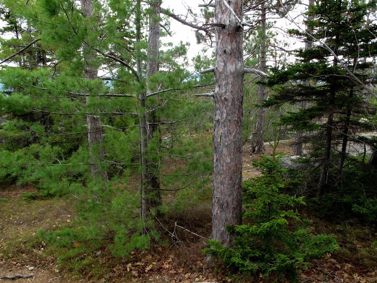 This Red pine (Pinus resinosa) in aan indicator of a "dry site". Red pine is famous on the south end of the Moats because of a number of spectacularly large individuals specimens growing there. The bed rock is exposed in a few places at this site and the soil is thin, characteristic of a warm-dry site. White pines, balsams and a black spruce are also found at this site (in the photo). The presence of the balsam-black spruce indicate the site may be in gradual transition to a balsam-spruce climax. The presence of the balsam-spruce might also be random coincidence.
 An intrusive dike cutting the Moat volcanic bed rock. Thom Davis noted that it "looked like there are large porphyritic inclusions" within the dike.
 Thom Davis wasn't sure what this is just from looking at a photo but it's volcanic and in the zone Billings noted was the lower limits of the Moat volcanics. It might be rhyolite or trachyte..
 As the trail reaches the mid point the view south begins to open towards Mt. Chocorua and the Sandwich Range.
 The elevation here is about 2,000 feet which is quite low compared to the ridge itself and what you see is an atypical warm site with spruce and white pine mixed in. This site, in the event of a wildfire breaking out here would burn at lethal temperatures due to the presence of the spruce and pine that would pull the fire up into the crowns of the trees.
 Here is an example of rock fractured by intense heat at ground level, and an indication the area was subjected to a very hot wildfire in the past and probably more than once. Such fires usually form a pattern depending on fuel, amount of moisture in the surrounding vegetation, wind, etc. The cycling of wildfires every three or four decades is common and probably goes back to the culmination of the last of the continental ice sheets thousands of years ago. In the post glacial time period the early human inhabitants in the Saco valley used fire to improve hunting areas and to control habitats for other uses including agriculture (S. Laurent, personal conversation). It might be possible that some fires on Moat were set by humans in order to improve acorn crops or clear underbrush to make large animals, like deer, easier targets at they foraged acorns.
 Another heat fractured rock and, behind it, a red oak tree that's another indicator that wildfires occurred here. The oak has three trunks joined at the base. The three stems grew from root collar spouts that sprouted from the original tree's roots that were damaged by wildfires here. Several tree species but mainly oak, survive wildfires by growing these "root collar sprouts". It reported that trees damaged the most send up the most sprouts. The sizes of these trunks indicate the site was burned 40-50 years ago.
 This site with sprouted oaks, thin soil, and the ribs of volcanic rocks that act as funnels for water running off the steep slope is a typical of warm-dry environments. The white pine tree in the background is another indicator species (when not growing with balsam and spruce) frequently found growing in disturbed areas including burned over sites.
 The soil in the warm-dry habitats is typically thin, consisting mostly of gravels and fines, because anything remotely organic was consumed by past fires. Rain water run-off on the steep slope erodes soil and carries it down to flatter areas below.
 A little higher I passed this site which still qualifies as a warm-dry habitat and has a mix of hardwoods growing on it including both red oak and occasional red pines.
 The red pine is found in these warm-dry environments and is also adapted to fire-prone areas. The cones of some pines only open when they're subjected to intense heat from wildfires. On the eastern slope of the Rocky Mountains in places like Yellowstone National Park, the Black Hills, and the Bear Lodge Mountains the native pines are strictly fire dependent for propagation. The eastern Red pine has adapted to wildfires but it not dependent on them for propagation. Two factors make fire favorable to the red pines. One is that fire burns the thick "duff" that forms on the forest floor in red pine stands but that is a physical barrier to the red pine seeds. Another that has been reported is the duff contains pathogenic chemicals that kills the seedlings.
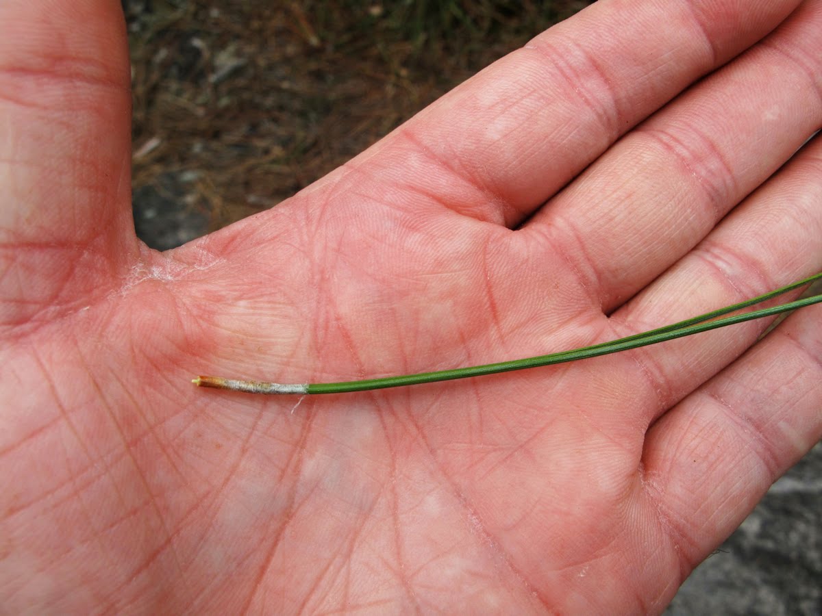 Red pine has leaves with two long needles. It's also called Norway pine and was popular as a wind break on farms and along roads across rural New England in the 1930s and 40s. It was planted in long, even parallel rows several rows across.
 In the next two photos you see the key characteristic of this dry site: the steep ledge that is sloped towards the sun from which it receives insolation winter and summer. The steep ledge also provides rapid drainage of water which insures the site's dry microclimate. Lastly, we have the thin soil, sprouted oaks and clusters of red pine.
 This is the upper most area of the somewhat unique dry habitat seen from above the ledge in the upper photo and looking east towards the long ridge of South Moat and you can see how a wildfire would find lots of fuel to burn. The understory here includes some Ericaceous plants (e.g. kalmia, bueberries, etc) that are also characteristic of these dry-warm sites.
 The South Moat trail gets an enormous amount of foot traffic due to the accessibility of the Moats and is badly eroded in places. It needs some work or possibly a relocation in a few places like this one. The erosion is exacerbated by the steepness of the slope and the rapid water runoff from storms and melting snow which uses the trail as a "gutter".
  The balsam fir, red spruce, and white pines return to the forest mix higher on the ridge where they reveal the top edge of the dry area. The reindeer lichen (Cladonia uncialis, or C. rangiferina) in the left center of the photo indicate that hasn't been burned over in at least 30 years are more. Reindeer lichen is the indicator as it takes more than 30 years to re-inhabit a fire site.
An interesting research project might be to do a long term study of this warm-dry environment on South Moat looking more closely at the geology-ecology interface. These areas abound on the southern slopes of the lesser peaks in the White Mountains.
 This red pine demonstrated that this species, like the black spruce in the alpine zone, can reproduce by "layering" which occurs when the lowest branches of the tree come in contact with the ground and put out filamentous roots that, at first, anchor the tree to the soil, but allow the branch the option of becoming a separate, independent plant.
 A black spruce near the summit.
Different types of habitats overlap each other between the bottom and top of the mountain, with the warm-dry site just explored on the mid-to-lower half of the mountain, and then closer to the summit of South Moat the habitat, including the vegetation, assumes what is the norm for this altitude and climate. South Moat is just under 3,000', and not considered a high mountain, but the upper portion of the mountain is often exposed to fierce winds and cold temperatures. I've been on the ridge in January when the temperature is -15 degrees (F) with 30-40 mph winds.
 The fracturing in these rocks just below the summit may have been caused at one time by intense heat from a wildfire but the fracturing continues year to year from freeze-thaw cycles.
 Closer to the summit, too, the trees look more spindly. The rock is Conway granite, the biotite granite as described by Billings.
 Here the bed rock close to the summit has weathered extensively. Note the different species of trees that are present in this photo: red pine, black spruce, and white pine with ericaceous ground cover.
 The "country rock" broken in to "jointed blocks" by frost wedging.
(I'm introducing some new terminology.)
 The summit of South Moat with the elegant slabs of Conway granite. In his long, detailed discussion Billings shows that the Conway granite is one of the younger rocks in the batholith but with painstaking detail comparing it to a number of other granites from around the mountains all with names reflecting the township where there was a "type locality": Albany granite, Meredith granite, Chatham granite, Hastingsite granite, riebeckite granite, etc., and these are just one class of silaceous rocks. There are also all the plutons of the Moat volcanics to analyze. In many cases it is the proportion of minerals that determine the minute gradations between one granite type and another and from that data derive a chronology of which came first, which is the oldest, etc.
 "Where are we..?". I like the guy in the middle on his cell phone. He's probably a lawyer.
 A close up of the famous Conway granite (Hitchcock's Biotite granite).
 Lecanora thomposonii (lichen) on Conway granite.
 I'm going to jump in now and tackle the White Mountain Alkaline Batholith. First I'll present a series of maps, or diagrams, that outline how information about the batholith evolved over the past 100-plus years. This map is by Billings (1928) but, earlier, C. H Hitchcock, in his 1870 "Geology of New Hampshire", made references to the batholith based on observations he had made of the composite rocks contained in the batholith and tried to date them. There's a long list of names of scientists who came before Billings completed the research discussed here between 1925-26. His Petrology of the North Conway Quadrangle was, up to 1928, the most striking description of the batholith and its important features (the Moat volcanic extrusions), including its size. We can see the black areas of the Moat volcanics located at several places including the Ossippe Ring Complex at the bottom of the map, Moat Mountain (M), Mt. Pequawket (P), Mt. Carrigain (C), and Twin Mountain (T). The larger heart shaped feature is the White Mountain Alkaline Batholith itself, underlying most of the White Mountains. Billings described the batholith as extending from the New Hampshire-Maine border its eastern edge, the Franconia ridge as the western edge (roughly 36 miles across) and by Fabyan's (the junction of Rts 3 and 302 near Twin Mountain) on the north and Mt. Chocorua on the south. He included Red Hill, the Ossippes, and a few other sites as satellitic "members" of the batholith.
Remember that a batholith is a large body of igneous (granitic) rock formed hundreds of millions of years ago by repeated intrusions of hot magma (lava) that rises from deep in the Earth's interior. The intrusive magma cools, forming a large, dome shaped "lens" of the igneous rock (granite is always an intrusive rock, formed beneath the earth's surface). Sometimes the basolith forms a huge cauldron-like body associated with volcanic activity. In these instances "stoping" occurs when the superheated magma begins to melt other types of rocks above and around the cauldron and huge chunks of this "other" rock fall into the magma. Some of the stoped rocks melt and are incorporated into the magma, some unincorporated and do not melt completely and end up as "xenoliths". (there's a diagram of the process below). At any rate, the basoliths remain several miles below the earth's surface until time and erosion bring the surface down to them.
Also remember that, according to Billings, The White Mountain Alkaline Batholith, dates to approximately 200-180 ma (million years ago) and it's creation involved several separate periods of volcanic activity some of which reached the Earth's surface as lava spewing upwards in "pyroclastic eruptions" (wild, fiery, hot right in what is now sleepy, downtown Conway, NH). The larger event that may have caused the intense volcanic activity is thought to have been the massive tectonic plate movements (of ancient continents) associated with the opening of the Atlantic Ocean.
 An updated (1935) map of the White Mountain Alkaline Batholith made by Charles Williams and Randolph Chapman, students of Billings, which reveals additional data collected by a growing number of people in the field. Billings supervised Chapman and Williams in their respective doctoral projects. Williams was working on the Franconia quadrangle and Chapman was working on the Percy Peak quadrangle. Reading various accounts of the enormous work required to write these geologic "novels" I was impressed by the high levels of reciprocal, collaborative research occurring between the students and Billings, a cross fertilization you could say, and the ever increasing accuracy of the data was an important result.
From Billing's 1925-1926 field work he constructed this table indicating the geologic continuum leading to the present time:
Pre-Cambrian I (?) Montalban schists, shales, limestone and sandstone.
Pre-Cambrian II (?) Chatham and Meredith granite (non-porphrytic).
Folding of sedimentary rocks, addition of more granites.
Silurian 435-410 Ma Intervale Clay Slates, muds, sands, Orogenisis (mountain building).
Devonian 410-360 Ma White Mountain Alkaline Batholith, lava flows, tuffs,
Breccias, intruded diorite, syenites, and granites; thePre-Cambrian I (?) Montalban schists, shales, limestone and sandstone.
Pre-Cambrian II (?) Chatham and Meredith granite (non-porphrytic).
Folding of sedimentary rocks, addition of more granites.
Silurian 435-410 Ma Intervale Clay Slates, muds, sands, Orogenisis (mountain building).
Devonian 410-360 Ma White Mountain Alkaline Batholith, lava flows, tuffs,
Plutonic phase.
Mesozic-Tertiary 140 Ma Subaerial denudation with repeated uplifts.
Quartenary 2.6 Ma Glaciation/post glacial, alpine (local) and continental
 Billings drew these diagrams (1928)(p. 129) to illustrate the following discussion. He wrote, "The area of the White Mountain batholith incloses (sic) five major volcanic masses, which vary from two to eight miles in diameter--Mt. Pequawket, Moat Mountain, the Ossipee Mountains, Mt, Carrigain, and Twin Mountain. (fig 4, above). Are the volcanics merely roof-pendants projecting down into the batholith or are they blocks that have settled from above? I believe that they are great blocks that have settled from above. The basis of the argument is the fact that the volcanics occur only within the limits of the batholith and its satellitic stocks; nowhere are they found beyond the limits of the batholith." (128)
The volcanics were extruded upon a surface composed of slates, schists, and musvoctite-biotite granites, for fragments of these rocks are found in the breccias. (see Figure 7a above) If we assume the batholith to have stoped up into its roof, any roof-pendants that are left, as for example "R" in the diagram, would be composed of the same formation as the walls of the batholith, Montalban schists in the case illustrated. If stoping continued into the volcanics the same rule would hold; the walls and any roof-pendants would be composed of volcanics. But in the case of the White Mountains neither of these relations holds. We have great blocks of Moat volcanics within the limits of the batholith and its satellitic stocks, but nowhere outside of these areas do we find volcanics; we find only the rocks of the basement on which these volcanics were deposited." (128) Billings goes on to analyze an alternative scenario involving the same results but argues against it saying, "But if this were so, the exposures of the volcanics would occupy only the highlands and the older basement rocks would be in the lowlands. (Fig. 8) However in the White Mountains the relations are just the reverse, for the schists and gneissic mountains are higher than the volcanic mountains. The most logical explanation is that the volcanics have settled into the batholith from above." (128) This brings us to the two diagrams below which pull all this information together for us. At the same time he's saying Mt. Peqauwket was one of those blocks that settled into the batholith as was Mt. Carrigain. Those are big blocks!
 Billings most brilliant conclusion occurs at this juncture when he concludes that the Moat and Pequawket mountains are isolated xenoliths (massive blocks) that became completely immersed in the magma as the batholith was forming.(They were stoped!) "In Moat Mountain," he writes," the lowest exposed horizon of the volcanic group is at 900 feet (a.s.l.). In other words the base of the volcanics is less than 900 feet; how much lower we have no way of telling. The western part of the Moat mass has settled therefore at least 5,000 feet below its original level,. By simple trigonmetry it may be demonstrated that in the northeastern protion of Moat the lowest know horizons are at least 17,000 feet below their original level. That this down singling took place during the intrusion of the batholith and not later is shown by the intrusive nature of the contacts between the Moat volcanics and the biotite granites." (130)
 Here is the biotite granite (Conway granite) perched on top of South Moat (Mts. Chocorua, Tripyramid, Osceola, and Tecumseh are in the distance). There is some confusing, complex reasoning involving the overall process but this is the picture Billings creates in words: "We may assume that after a long period during which the magma was working upward, presumably by stoping, a stage was reached in which the roof was too thin for full support and began to break up into large blocks that would sink into the magma below (stoping). By this collapse of the roof over the batholith great differences in relief would result and great quantities of coarse sediment would pour into the collapsing area. Presumably the whole roof would settle, but it would undoubtedly break up into subsidiary blocks sinking at different rates. Accompanying collapse great quantites of magma would well up along the fracture-planes to form surface flows, accompanied by considerable explosive activity. As collapse continued, great flows would flood the region, and vast quanties of detrital matter, mingled with explosive ejecta, would be swept in from the highlands to the lowlands. Probably at no time would the uncongealed magma in the upper portions of the batholith be exposed directly to the air; instead it would well up around the collapsing blocks (the Moat volcanics) to pour forth as lava flows." (130)
So within that description we have these enormous, isolated blocks of Moat volcanics eroded down into Moat Mountain, Carrigain, Peqauwket, etc. . The image of the lava flowing about, all that fire and brimstone mixing things up, is quite enticing.
 I find Mt. Carrigain one of the most beautiful of the White Mountains perhaps because of the way it stands apart and towers above the surrounding wilderness. In the early 1960's the abandoned fire tower on top of Carrigain sported a queen sized mattress. I have no idea how it got there or who packed it up there. For all the packing I did I never tackled a queen sized mattress and wouldn't really want to, but it made the tower a very appealing Days Off (Daze) spot. I spent many days and nights there often sitting through harrowing thunderstorms (Thumpers) totally freaked out, hair standing on end, not from electricity but from adrenalin. I would watch the thumpers streaming rapidly across the Pemigewasset, bearing down from Franconia Ridge, thunder roaring and cracking around me, and be a total wreck as I anticipated the tower going down in flames as the storms engulfed the mountain. In just a few minutes, the inevitable clearing would come and there would be these spectacular sunsets and all my fear would seem comical. When not riding out thumpers I would read Kerouac and bushwhack to places nearby like the Captain, the Hancocks, and Carrigain pond or down into Carrigain Notch.
 Thunderstorm over the Franconia Ridge from the Carrigain fire tower July 1961
 Carter Notch in a telephoto from S. Moat.
In talking about the batholith we are primarily describing a sequence in the geological time span of the White Mountains. The batholith represents a distinct span of time in the local geologic history and the work in defining the chronology of batholith is about partializing the lithologies of the different rock types and decipher their relative ages. The Moat volcanics were good indicators that have helped determine the age of the batholith and from the Moat volcanics Billings, and others, have been able to establish a definitive time line to work from.
 Looking up the East Branch valley of the Saco River with Humphrey Ledge in the foreground, Thorn Mountain, Double Head, and in the back the north and south Baldfaces. (from S. Moat).
The Baldfaces, although satellitic to the White Mountain Alkaline Batholith are fequently included in Billing's discussion about the batholith primarily because of the the fine granites that occur in the Baldfaces. For instance, Billings observed that the best exposed "contact-phase" of the Conway biotite granite is to be seen on the west slope of these two mountains (not on S. Moat) where the country rock is Meredith granite. The biotite granite covers the entire summit area of North Baldface and Billings noted that the "contact between the two granites, on the whole, has a relatively regular trend but in detail it is quite jagged where numerous dikes of the biotite granite cut the Meredith granite" making it clear that the biotite (Conway) granite is the younger of the two. This points to the existence of many rules of thumb in the classification process and that accurate classification comes from years of experience and a huge store of knowledge.
 The Baldfaces from South Moat in a telephoto.
To give an impression of the painstaking process of classifying rock-types I'm including the following table from Billing's 1928 "Petrology" paper. It's an analysis of the trachyte from South Moat compared with trachyte from other sources in the White Mountains. Billings went to some length to have the analysis completed by one of the best analysts in the business at that time, William Herdsman of Glasgow, Scotland. The results are fascinating particularly in pointing out the complex chemical compounds in a nominal sample of trachyte in addition to the minute variations between samples from different locations. These minute variations between samples is what I find fascinating.


 This is Billing's chronological list of rocks that formed the White Mountain Alkaline Batholith. There's a lengthy, detailed discussion of the nordmarkite porphyry that's a little dry for leisurely reading but it includes his analysis with the myriad details that reveal what his work really consisted of in understanding the scope and importance of the batholith. It's also too long to quote but here is a short example: "The nordmarkite porphry has been observed in five small areas. Two represent small stocks satellitic to the main batholith. Two others are border phases of the nordmarkite of the main batholith. The fifth body is completely surrounded by the Albany porphyritic nordmarkite. The satellitic stock on Mt. Eastman is about half a mile in diameter, although the exact boundary on the northeast slope could not be established. The Sloop Mountain stock is a long, dike-like body striking north; it is a mile and half long and a quarter of a mile wide. On the mortheast slope of Sable Mountain a belt at least half a mile long and perhaps a quarter of a mile wide is found between the nordmarkites and the older Meredith granite." It goes on like that for a full page. The gist of it is determing which comes first the Albany porphyritic nordmarkite or the nordmarkite porphyry and what you need to know to decide. For Billings it was these two bits of data: "Dikes of nordmarkite porphyry cut the Montalban schists at an elevation of 1450 feet, and the Chatham granite at an elevation of 1040 feet in the flume of Chandler Brook. It is thus younger than the Pre-Cambrian (?) formation. On the other hand it is older than the nordmarkites of Chandler Mountain as already stated. Thus the normarkite porphyry is to be considered an early phase of the White Mountains batholith." (104). It's an impressive, painstaking process.
 Moving ahead from Billings roughly 70 years to the 1990s and looking at some changes that have been made to Billing's map of the White Mountain Batholith. This map is from notes for a geology field trip designed by John Creasy of Bates College in Lewiston, ME, together with John Fitzgerald of Cambridge, MA. under the title Bedrock Geology Of The Eastern White Mountain Batholith, North Conway Area, New Hampshire. (I believe it was published in 1993) Creasy's map is far more complicated than Billing's and Randolph Chapman's with the inclusion of compilations of more recent field work by a host of geologist and geology students. It's also more impressive in terms of how much information is necessary to understand and appreciate the batholith's importance to the natural history of the White Mountains.
Creasy wrote, "Emplacement of the batholith occurred in middle and late Jurassic time, 201-155 Ma. The western half of the White Mountain batholith, exposed in the Franconia and Cawford Notch 15' quadrangles, contains three igenous centers (W1-3) the largest of which is 20 km in diameter. Igneous activity commenced in the western batholith with emplacement of the porphyritic quartz syenite (201 Ma and 193 Ma) and the quartz phorphyry (195 Ma) of center W1
 The eastern portion of the White Mountain batholith, exposed in the North Conway and Crawford Notch 15' quadrangles, has at least four magmatic centers (Figure 3). Two centers with thick pyroclastic successions are interpreted a calderas (Noble and Billings, 1967; Fitzgerald, 1987; Fitzgerald and Creasy, 1988). Other centers where ring dikes or chrescent-shaped intrustions are associated with epizonal plutons define more deeply eroded calderas. Cladera development here post-dates similar events in the western batholith by about 10-20 Ma. Dated units include the rig dike of center E2 (179 Ma); the Moat Mountain volcanic sequence (173-168 Ma) and rig dike (170 Ma) of center E3; and plutons of biotite granite (171 Ma and 155 Ma). We interpret the White Mountain Batholith as a sub-horizontal slice through a caldera field cut about 1.5 Km thick and 1-2 Km below the original land surface." (Ibid)
"Mt. Osceola Granite, a green amphibole +/- biotite granite, is the oldest member of the White Mountain magma series exposed in the North Conway quadrangle (Osberg and others, 1978; Eby and others, 1992). The number and original extent of plutons of the Mt. Osceola Granite within the North Conway quadrangle is not fully certain due to the complexity and abundance of younger rocks. A whole-rock Rb-Sr isochron for samples from both eastern and western portions of the batholith yeilds an age of 186 m.y. (Eby and others, 1992) and indicates synchronous intrusions over a broad area. Ufliss age places the Mt. Osceola as the youngest member associated with the large magmatic center that forms the western portion of the batholith." (Ibid)
Then this: "The Mt. Osceola granite, the quartz syenite of Mt. Tremont, and the riebeckite granite, respectively, were derived from the same or similar magmas that had undergone increasingly greater degrees of crystal fractionation. The apparent variation in degree of fractionation may reflect the sequential evolution of a single parent magma or may result from the exposure, at current levels of erosion, similar magmas that had fractionated to differing degrees." (Ibid)
The last part is astonishing as it addresses what we are led to conclude from Billing's earlier work in terms of minute variations and how they form. The concept of single and multiparent magmas accounts for the degree of fractionation and its impact on the degree of variation.
 Finally we get back to Moat Mountain in this is a diagram made by Creasy and Fitzgerald with the trachyte of the Moat volcanics as a black "apron" easily identified on the southeast ridge. Creasy and Eby reported that the "absolute ages for the plutons in the North Conway quadrangle are within the range of 183-155 Ma. That includes the Moat volcanics. In other words they've gotten younger since Billings dated them in 1926.
 With the batholith explained, at least in part, it's time to head down. I'm writing these last bits in January 2011 and it's fun to look back on my hike up South Moat. These cherry blossoms evoke the thought of the beauty that can be found in every season.
 Striped maple leaves springing from an open cotyledon.
 Sweethearts.
 Still life with Moat volcanics and glacial erratic.
 Red oak acorns and glacial erratics.
 Thom Davis identified this as a volcanic agglomerate (as opposed to a conglomerate) due to the fact there's no congolmerate bedrock on the Moats.
 The End.
6 comments:
Thanks for posting these pictures from Moat Mountain. I used to hike that for training when I was a teenager. My best effort was from Dugway Rd to South Moat in 42 minutes in 1974. It's good to see the pictures and see that the mountain looks the same today.
Alex, I didn't quite fully get to push through the batholith part, but have plenty of time to read up on that. What I found interesting was the part about hemlocks. As you point out, hemlocks are commonly associated with cool, wet sites. However, I think it's really neat to point out that these conditions only exist in those areas due to the presence of hemlocks. If you look at the germination requirements of hemlock, it's actually interesting to see that they need a decent temperature in order to successfully germinate, yet at the same time, the seedlings cannot withstand drought, so they do require the shade of other trees in order to grow.
"Contrary to common belief, the species requires a warm, moist site for stand establishment rather than the cool, moist conditions that usually develop as stands mature." - http://www.na.fs.fed.us/spfo/pubs/silvics_manual/Volume_1/tsuga/canadensis.htm
I wanted to say thanks for the great presentation. I am hiking the Moats after so many years of passing them by. You gave a wonderful prep, photos and info. Views of above, around, below and under my feet. Just filled up my imagination.
A good friend, John, spoke with me several years ago, "Have you hiked the Moats". he asked. "No! You should". Well, John I get the Moats this year. Alex, you will make this hike again with me. Thanks.
What a great work, collection of information. Thank you for providing me a new appreciation of al already appreciated area
It is not the case that 'the North Conway Quadrangle is blank next to the letter "C".':
The North Conway Quadrangle is filled-in next to the letter "C"; the "(Crawford Notch)" quadrangle is blank at C4.
Interesting, meandering, entertaining narrative, but even with your writing skill, the local geology is quite a jumble for even the keenest geologist to describe. Personally, I am not completely convinced that all of the complex intrusive and extrusive igneous prehistory of New Hampshire is fully understood, even today.
Post a Comment